14.7 km
~3 hrs 42 min
466 m
“Explore diverse landscapes and historical landmarks on the North Canyon and Slope Loop Trail in Benton County.”
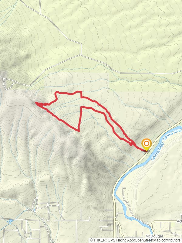
Starting near Benton County, Washington, the North Canyon and Slope Loop Trail offers a moderately challenging hike that spans approximately 15 kilometers (around 9.3 miles) with an elevation gain of about 400 meters (1,312 feet). This loop trail is perfect for those looking to experience a variety of landscapes, from lush canyon floors to panoramic slope views.
### Getting There To reach the trailhead, you can drive or use public transportation. If driving, head towards Benton County and look for the nearest significant landmark, the Benton City Park. From there, follow local signage to the trailhead. For those using public transport, the nearest bus stop is at Benton City Park, from where you can either walk or take a short taxi ride to the trailhead.
### Trail Overview The trail begins with a gentle ascent through a shaded canyon, where the air is cooler and the vegetation is dense. Early on, you'll encounter a variety of native plants, including sagebrush and wildflowers, especially vibrant in the spring. Keep an eye out for mule deer and the occasional coyote, which are common in this area.
### Significant Landmarks At approximately 3 kilometers (1.86 miles) into the hike, you'll come across an old homestead. This site offers a glimpse into the region's history, dating back to early settlers who farmed and lived off the land. The remnants of the homestead, including a dilapidated barn and rusted farming equipment, provide a poignant reminder of the area's past.
### Elevation Gain and Scenic Views As you continue, the trail begins to climb more steeply, gaining about 200 meters (656 feet) over the next 4 kilometers (2.5 miles). This section can be strenuous, so take your time and enjoy the increasingly expansive views of the surrounding valleys and distant mountains. The trail levels out at the top of the slope, offering a perfect spot for a break and some photos.
### Wildlife and Flora The higher elevations are home to a different set of flora and fauna. Here, you might spot golden eagles soaring overhead or hear the distinctive call of the western meadowlark. The plant life also changes, with more hardy shrubs and fewer trees, giving the area a more open, windswept feel.
### Navigational Tips Given the trail's moderate difficulty and varied terrain, it's advisable to use a reliable navigation tool like HiiKER to keep track of your progress and ensure you stay on the correct path. The trail is well-marked, but having a digital map can be reassuring, especially in areas where the path may be less distinct.
### Return Loop The descent begins around the 10-kilometer (6.2-mile) mark, where the trail loops back towards the canyon. This section is less steep but can be rocky, so watch your footing. As you make your way down, you'll pass through a series of switchbacks that offer different perspectives of the landscape, making the descent as visually rewarding as the climb.
### Final Stretch The last 2 kilometers (1.24 miles) bring you back into the canyon, where the trail flattens out and the vegetation becomes denser again. This is a good time to reflect on the diverse ecosystems you've traversed and perhaps spot some of the smaller wildlife, like lizards and various bird species, that thrive in this sheltered environment.
This trail offers a comprehensive experience of the natural beauty and historical significance of the Benton County area, making it a rewarding hike for those prepared for a moderate challenge.
Reviews
User comments, reviews and discussions about the North Canyon and Slope Loop Trail, Washington.
4.0
average rating out of 5
13 rating(s)


