Download
Preview
Add to list
More
16.2 km
~1 day 1 hrs
1654 m
Out and Back
“Experience a rewarding 16-km adventure with panoramic views and historical charm on Malans Peak and Mount Ogden Trail.”
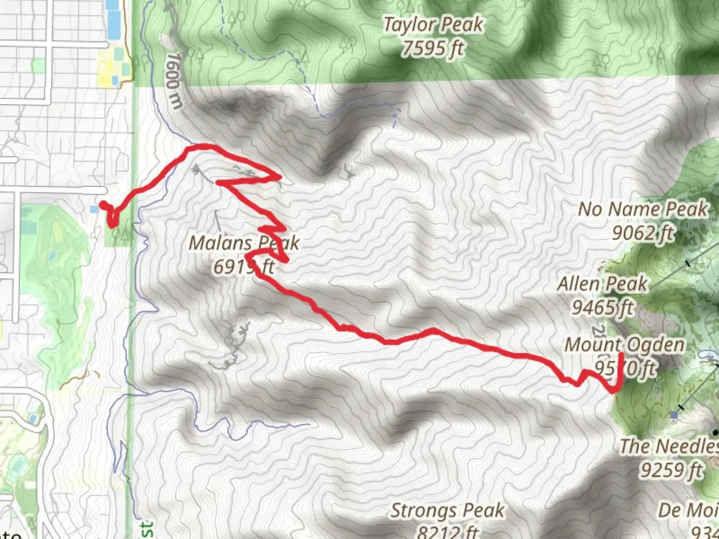
Starting your hike near Weber County, Utah, the Malans Peak and Mount Ogden via Malans Basin Trail offers a challenging yet rewarding adventure. The trailhead is conveniently located near the 29th Street Trailhead Park, which is easily accessible by car. If you're using public transport, the nearest bus stop is at Harrison Blvd and 29th Street, from where it's a short walk to the trailhead.
Trail Overview
The trail spans approximately 16 kilometers (10 miles) round trip, with an elevation gain of around 1600 meters (5250 feet). This out-and-back trail is rated as medium difficulty, making it suitable for hikers with some experience and a good level of fitness.
Initial Ascent
The first section of the trail takes you through a series of switchbacks, gaining elevation quickly. You'll ascend about 300 meters (1000 feet) within the first 2 kilometers (1.2 miles). The path is well-marked and maintained, but be prepared for a steady climb. As you ascend, you'll be treated to views of the Ogden Valley and the Great Salt Lake in the distance.
Malans Basin
At around the 4-kilometer (2.5-mile) mark, you'll reach Malans Basin, a beautiful, flat area surrounded by towering cliffs. This is a great spot to take a break and enjoy the scenery. Historically, Malans Basin was the site of a small resort in the late 1800s, which was accessible by a tramway. Although the resort no longer exists, remnants of the old tramway can still be seen.
Malans Peak
Continuing from Malans Basin, the trail becomes steeper as you make your way to Malans Peak. The peak is located approximately 6 kilometers (3.7 miles) from the trailhead and sits at an elevation of about 2100 meters (6890 feet). From here, you'll have panoramic views of the Ogden Valley, the Great Salt Lake, and the Wasatch Range. This is a popular spot for photography, so don't forget your camera.
Mount Ogden
For those looking to extend their hike, continue on to Mount Ogden. The trail from Malans Peak to Mount Ogden is less traveled and more rugged. You'll cover an additional 2 kilometers (1.2 miles) and gain another 400 meters (1310 feet) in elevation. Mount Ogden stands at approximately 2900 meters (9510 feet) and offers even more expansive views. On a clear day, you can see as far as the Uintas and the Oquirrh Mountains.
Flora and Fauna
Throughout the hike, you'll encounter a variety of flora and fauna. The lower sections of the trail are dominated by scrub oak and sagebrush, while higher elevations feature pine and aspen forests. Wildlife is abundant, with chances to see deer, marmots, and a variety of bird species. Keep an eye out for raptors soaring above the cliffs.
Navigation and Safety
Given the elevation gain and the rugged terrain, it's essential to be well-prepared. Use HiiKER for accurate trail maps and navigation. Ensure you have plenty of water, snacks, and appropriate clothing for changing weather conditions. The trail can be icy and snow-covered in the winter months, so crampons and trekking poles are recommended during this time.
Getting There
If driving, head to the 29th Street Trailhead Park in Ogden, Utah. Parking is available, but it can fill up quickly on weekends. For public transport users, take a bus to the Harrison Blvd and 29th Street stop, and walk east to the trailhead.
This trail offers a mix of natural beauty, historical significance, and physical challenge, making it a must-do for any avid hiker in the region.

What to expect?
Activity types
Comments and Reviews
User comments, reviews and discussions about the Malans Peak and Mount Ogden via Malans Basin Trail, Utah.
4.31
average rating out of 5
16 rating(s)