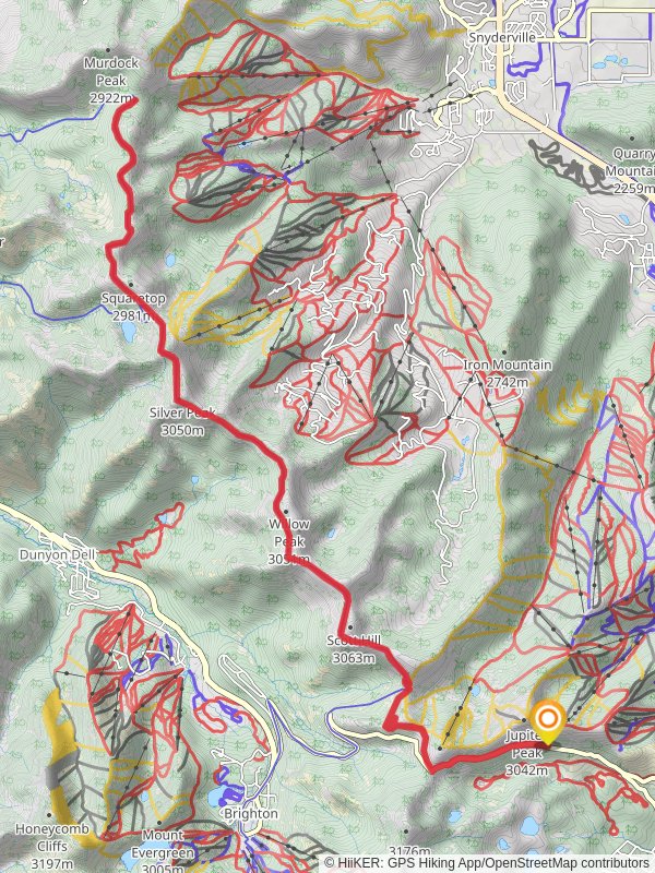
Wasatch Crest Trail via Scott's Bypass
29.6 km
~1 day 2 hrs
1126 m
“The Wasatch Crest Trail via Scott's Bypass offers stunning views, diverse wildlife, and moderate challenges for experienced hikers.”
Starting near Wasatch County, Utah, the Wasatch Crest Trail via Scott's Bypass is a stunning out-and-back hike that spans approximately 30 kilometers (18.6 miles) with an elevation gain of around 1100 meters (3609 feet). This trail is rated as medium difficulty, making it accessible for moderately experienced hikers.### Getting There
To reach the trailhead, you can drive or use public transportation. If driving, head towards Guardsman Pass Road, which is the nearest significant landmark. For those using public transport, the closest major city is Salt Lake City. From there, you can take a bus or shuttle service to Park City and then a local taxi or rideshare to Guardsman Pass Road.### Trail Overview
The trail begins with a gradual ascent, offering panoramic views of the surrounding Wasatch Mountains. Early on, you'll encounter Scott's Bypass, a notable junction that diverts from the main Wasatch Crest Trail. This section is less crowded and provides a more serene hiking experience.### Key Landmarks and Sections
- Scott's Bypass (0-5 km / 0-3.1 miles): The initial stretch is relatively easy, with a gentle incline. You'll pass through dense forests of aspen and pine, which are particularly beautiful in the fall when the leaves change color.
- Desolation Lake (5-10 km / 3.1-6.2 miles): As you continue, you'll reach Desolation Lake, a pristine alpine lake perfect for a short break. The elevation gain here is about 300 meters (984 feet), making it a good spot to catch your breath.
- The Crest (10-15 km / 6.2-9.3 miles): This section is the most challenging, with steep inclines and rocky terrain. The elevation gain is around 500 meters (1640 feet). However, the effort is rewarded with breathtaking views of the Wasatch Range and the Salt Lake Valley.
- Mill Creek Canyon Overlook (15 km / 9.3 miles): The turnaround point offers a stunning overlook of Mill Creek Canyon. This is a great spot for photos and to take in the expansive views before heading back.### Flora and Fauna
The trail is rich in biodiversity. You may encounter mule deer, elk, and various bird species such as hawks and eagles. The flora includes wildflowers in the spring and summer, and the aforementioned aspen and pine trees.### Historical Significance
The Wasatch Mountains have a rich history, with evidence of Native American habitation dating back thousands of years. The area was also significant during the early days of Mormon settlement in Utah. The trail itself has been used for centuries, initially by indigenous peoples and later by settlers and miners.### Navigation and Safety
Given the trail's length and elevation gain, it's crucial to be well-prepared. Use HiiKER for accurate navigation and trail conditions. Ensure you have enough water, snacks, and appropriate clothing for changing weather conditions. The trail can be rocky and uneven, so sturdy hiking boots are recommended.### Final Tips
- Weather: Check the weather forecast before you go. The trail can be exposed in certain sections, making it susceptible to sudden weather changes.
- Permits: No permits are required for day hiking, but always check for any updates or restrictions.
- Leave No Trace: Pack out all trash and respect the natural environment to keep this trail beautiful for future hikers.
Reviews
User comments, reviews and discussions about the Wasatch Crest Trail via Scott's Bypass, Utah.
4.0
average rating out of 5
23 rating(s)
Loading reviews...


