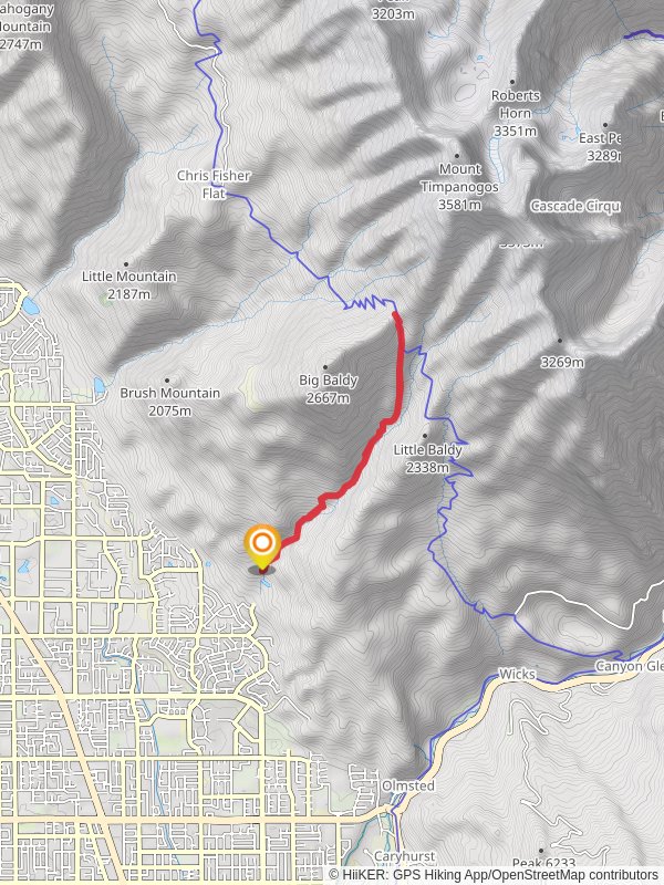
Dry Canyon Trail
8.8 km
~3 hrs 20 min
952 m
“Embark on the 9-kilometer Dry Canyon Trail for a medium-difficulty hike with stunning Utah Valley views.”
Starting near Utah County, Utah, the Dry Canyon Trail is an invigorating out-and-back hike that spans approximately 9 kilometers (5.6 miles) with an elevation gain of around 900 meters (2,950 feet). This trail is rated as medium difficulty, making it suitable for moderately experienced hikers looking for a rewarding challenge.### Getting There
To reach the trailhead, you can drive or use public transportation. If driving, head towards the city of Lindon, Utah. The nearest significant landmark is the Lindon Marina, located at 2130 W 600 S, Lindon, UT 84042. From there, follow local roads to the Dry Canyon Trailhead. For those using public transport, the Utah Transit Authority (UTA) offers bus services that can get you close to Lindon, but you may need a short taxi or rideshare trip to reach the trailhead.### Trail Overview
The trail begins with a gentle ascent through a shaded canyon, offering a cool and refreshing start. As you progress, the path becomes steeper and more rugged, so sturdy hiking boots are recommended. The initial 1.5 kilometers (0.9 miles) will take you through a mix of scrub oak and maple trees, providing ample shade and a beautiful array of colors in the fall.### Significant Landmarks and Nature
At around the 2-kilometer (1.2-mile) mark, you'll encounter a small, picturesque waterfall. This is a great spot to take a short break and enjoy the sound of cascading water. Continuing on, the trail opens up to more exposed terrain, offering panoramic views of Utah Valley and the surrounding mountains. Keep an eye out for local wildlife, including mule deer, wild turkeys, and various bird species.### Elevation Gain and Terrain
The elevation gain becomes more noticeable after the 3-kilometer (1.9-mile) point, where the trail zigzags up the canyon walls. This section can be quite strenuous, so take your time and stay hydrated. The trail surface varies from packed dirt to loose rocks, so watch your footing.### Historical Significance
The Dry Canyon area has a rich history, once serving as a route for Native American tribes and later for early settlers in the region. Artifacts and remnants of old trails can sometimes be spotted, adding a layer of historical intrigue to your hike.### Navigation
Given the varying terrain and potential for losing the trail in some sections, it's advisable to use a reliable navigation tool like HiiKER to keep you on track. The app provides detailed maps and real-time location tracking, ensuring you stay on the correct path.### Final Stretch
As you approach the 4.5-kilometer (2.8-mile) mark, the trail levels out slightly, leading you to a stunning overlook point. Here, you can take in sweeping views of the valley below and the Wasatch Range in the distance. This is the turnaround point for the out-and-back trail, making it a perfect spot to rest and refuel before heading back down.### Wildlife and Flora
Throughout the hike, you'll encounter a diverse range of flora, from wildflowers in the spring to vibrant autumn leaves. Wildlife is abundant, so keep your camera ready for unexpected encounters. Always remember to respect the natural habitat and maintain a safe distance from any animals you encounter.### Return Journey
The descent offers a different perspective of the canyon, with the changing light creating new photo opportunities. While the downhill trek is less strenuous, it requires careful navigation due to loose rocks and steep sections.Prepare adequately with water, snacks, and appropriate gear, and you'll find the Dry Canyon Trail to be a rewarding and memorable hiking experience.
Reviews
User comments, reviews and discussions about the Dry Canyon Trail, Utah.
4.0
average rating out of 5
19 rating(s)
Loading reviews...


