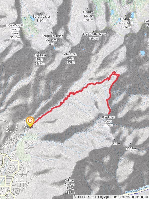
Box Elder Peak via Deer Canyon Dry Creek Trail
21.6 km
~1 day 2 hrs
1904 m
“Embark on a challenging 22-km adventure through diverse landscapes to the panoramic summit of Box Elder Peak.”
Starting your adventure near Utah County, Utah, the Box Elder Peak via Deer Canyon Dry Creek Trail is an invigorating out-and-back hike that spans approximately 22 kilometers (13.7 miles) with an elevation gain of around 1900 meters (6234 feet). This trail is rated as medium difficulty, making it suitable for hikers with some experience and a good level of fitness.### Getting There
To reach the trailhead, you can drive or use public transport. If driving, head towards the Dry Creek Trailhead, located near Alpine, Utah. The nearest significant landmark is the Alpine City Park, which is a good reference point. For those using public transport, the Utah Transit Authority (UTA) offers bus services to Alpine, but you may need to arrange a taxi or rideshare for the final leg to the trailhead.### Trail Overview
The trail begins with a gentle ascent through Deer Canyon, where you'll be greeted by a lush forest of aspen and pine trees. Early in the hike, you'll cross Dry Creek, which can be a trickle or a more substantial stream depending on the season. This section is relatively shaded, providing a cool start to your journey.### Key Landmarks and Sections
- First 5 Kilometers (3.1 Miles): The initial stretch is a moderate climb with an elevation gain of about 300 meters (984 feet). You'll pass through dense forest and might spot wildlife such as deer and various bird species. Keep an eye out for wildflowers in the spring and summer months.
- Midpoint (Around 11 Kilometers / 6.8 Miles): As you approach the midpoint, the trail becomes steeper and more rugged. Here, you'll gain approximately 800 meters (2625 feet) in elevation. The forest begins to thin out, offering stunning views of the surrounding valleys and peaks. This is a good spot to take a break and hydrate.- Final Ascent: The last section of the trail is the most challenging, with a steep climb to the summit of Box Elder Peak. The elevation gain in this segment is around 800 meters (2625 feet) over a distance of 6 kilometers (3.7 miles). The terrain is rocky and exposed, so be prepared for wind and sun. The summit offers panoramic views of the Wasatch Range and Utah Valley, making the effort well worth it.### Historical Significance The region around Box Elder Peak has a rich history. The area was originally inhabited by the Ute Native American tribe, and later explored by Mormon pioneers in the mid-19th century. The trail itself has been used for decades by locals and visitors alike, drawn by the natural beauty and the challenge of the hike.### Wildlife and Flora Throughout the hike, you'll encounter a variety of flora and fauna. The lower elevations are home to aspen, pine, and fir trees, while the higher elevations feature alpine meadows and rocky outcrops. Wildlife sightings can include deer, elk, and occasionally black bears. Birdwatchers will enjoy spotting species such as the mountain bluebird and the golden eagle.### Navigation and Safety Given the trail's length and elevation gain, it's crucial to be well-prepared. Use HiiKER for accurate trail maps and navigation. Ensure you have plenty of water, snacks, and appropriate clothing for changing weather conditions. Trekking poles can be helpful for the steep sections, and always let someone know your hiking plans.This trail offers a rewarding experience with its diverse landscapes, challenging climbs, and breathtaking views. Whether you're a seasoned hiker or looking to push your limits, the Box Elder Peak via Deer Canyon Dry Creek Trail is a memorable adventure.
Reviews
User comments, reviews and discussions about the Box Elder Peak via Deer Canyon Dry Creek Trail, Utah.
5.0
average rating out of 5
14 rating(s)
Loading reviews...


