Download
Preview
Add to list
More
12.5 km
~4 hrs 23 min
1131 m
Out and Back
“Embark on the rewarding Deseret Peak Trail for stunning views, historical insights, and moderate hiking challenges.”
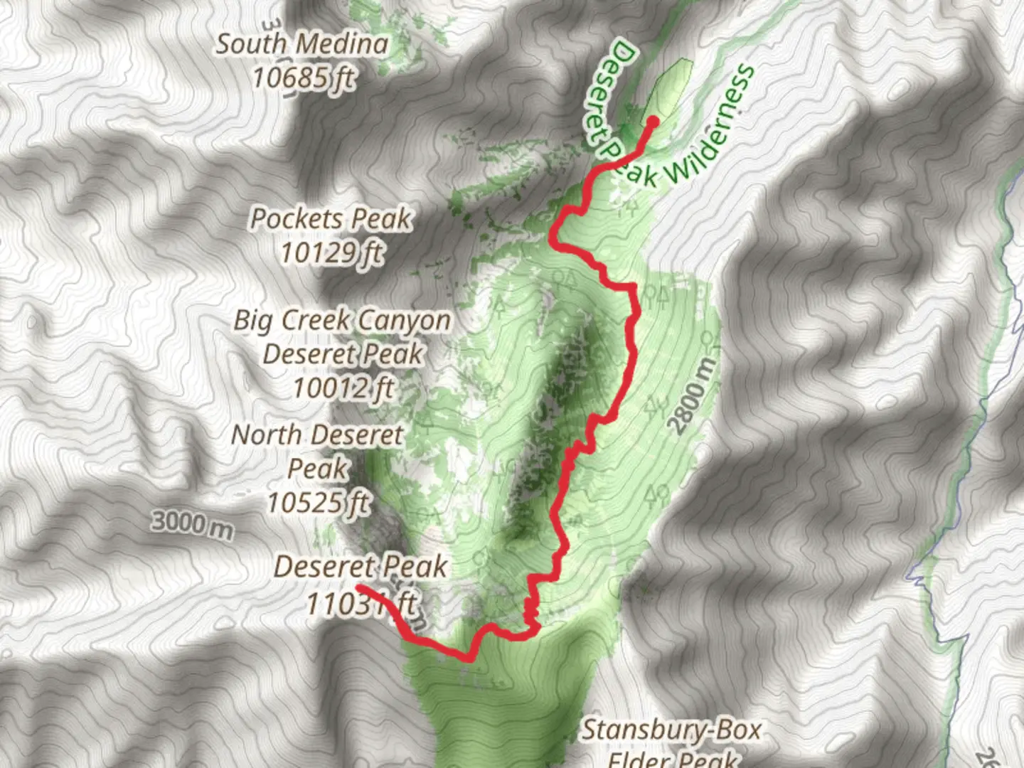
Starting your adventure near Tooele County, Utah, the Deseret Peak via Mill Fork Canyon Trail offers a rewarding out-and-back hike that spans approximately 13 kilometers (8 miles) with an elevation gain of around 1100 meters (3600 feet). This trail is rated as medium difficulty, making it suitable for moderately experienced hikers.
Getting There To reach the trailhead, you can drive or use public transportation. If driving, head towards the Stansbury Mountains, specifically the Deseret Peak Wilderness area. The nearest significant landmark is the Loop Campground, located at the end of South Willow Canyon Road. For those using public transport, the nearest major city is Salt Lake City. From there, you can take a bus or shuttle service to Tooele County and then a local taxi or rideshare to the trailhead.
Trail Overview The trail begins at the Loop Campground, where you will find ample parking and basic amenities. The initial section of the trail meanders through a dense forest of aspen and pine trees, offering a serene and shaded environment. As you ascend, the trail becomes steeper and rockier, so sturdy hiking boots are recommended.
Key Landmarks and Sections - **Mill Fork Canyon (0-3 km / 0-1.9 miles):** The first part of the trail takes you through Mill Fork Canyon. This section is relatively gentle, with a gradual incline. Keep an eye out for mule deer and wild turkeys, which are commonly seen in this area. - **Midway Point (3-6 km / 1.9-3.7 miles):** As you continue, the trail becomes steeper and more challenging. You'll pass through a series of switchbacks that offer stunning views of the surrounding valleys and peaks. This is a good spot to take a break and hydrate.
- Alpine Meadow (6-8 km / 3.7-5 miles): Around the 6-kilometer mark, you'll reach an alpine meadow filled with wildflowers during the summer months. The meadow is a great place to spot marmots and other small mammals. The trail here is less steep but still requires careful footing due to loose rocks.
Final Ascent and Summit - **Summit Push (8-10 km / 5-6.2 miles):** The final section of the trail is the most challenging, with a steep ascent to the summit of Deseret Peak. The trail here is exposed, so be prepared for strong winds and varying weather conditions. The summit offers panoramic views of the Great Salt Lake, the Bonneville Salt Flats, and the surrounding mountain ranges.
Historical Significance The Deseret Peak Wilderness area is rich in history. The name "Deseret" comes from the Book of Mormon and means "honeybee," symbolizing industry and perseverance. The region was historically used by Native American tribes and later by Mormon pioneers. The trail itself follows some of the routes used by early settlers and offers a glimpse into the rugged terrain they navigated.
Navigation and Safety Given the trail's elevation gain and varying terrain, it's advisable to use a reliable navigation tool like HiiKER to stay on course. Weather can change rapidly, so check forecasts and be prepared for sudden temperature drops, especially near the summit. Carry plenty of water, snacks, and a first-aid kit.
This trail offers a mix of natural beauty, challenging terrain, and historical significance, making it a rewarding experience for those who undertake it.

What to expect?
Activity types
Comments and Reviews
User comments, reviews and discussions about the Deseret Peak via Mill Fork Canyon Trail, Utah.
4.46
average rating out of 5
24 rating(s)