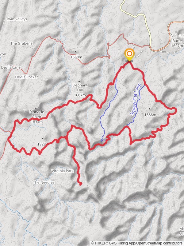
Squaw Flat Canton, Lost Canyon and Chesler Park Loop Trail
35.0 km
~1 day 4 hrs
1523 m
“The Squaw Flat Canyon, Lost Canyon, and Chesler Park Loop Trail offers a breathtaking, diverse 35 km adventure.”
Starting near San Juan County, Utah, the Squaw Flat Canyon, Lost Canyon, and Chesler Park Loop Trail is a captivating 35 km (21.7 miles) loop with an elevation gain of approximately 1500 meters (4921 feet). This medium-difficulty trail offers a diverse range of landscapes, from rugged canyons to expansive parklands, making it a must-visit for avid hikers.
### Getting There To reach the trailhead, you can drive to the Needles District of Canyonlands National Park. The nearest significant landmark is the Needles Visitor Center, located at 2282 SW Resource Blvd, Moab, UT 84532. From there, follow the signs to the Squaw Flat Campground, where the trail begins. Public transport options are limited, so driving is the most practical way to get there.
### Trail Overview The loop starts at the Squaw Flat Campground, where you can find parking and basic amenities. The first section of the trail takes you through Squaw Flat Canyon, characterized by its striking rock formations and narrow passages. As you ascend, you'll gain about 300 meters (984 feet) in the first 5 km (3.1 miles), offering panoramic views of the surrounding landscape.
### Lost Canyon Around the 10 km (6.2 miles) mark, you'll enter Lost Canyon. This section is more shaded and cooler, with lush vegetation and occasional water sources, especially after rain. The elevation gain here is moderate, adding another 200 meters (656 feet) over the next 5 km (3.1 miles). Keep an eye out for mule deer and various bird species that inhabit this area.
### Chesler Park The trail then leads you to Chesler Park, a vast, open area surrounded by towering sandstone spires. This is the most visually stunning part of the hike, with unique rock formations and wide-open spaces. The elevation gain here is more gradual, adding about 400 meters (1312 feet) over 10 km (6.2 miles). This section is perfect for photography, so make sure to bring your camera.
### Historical Significance The region is rich in Native American history, with numerous petroglyphs and ancient dwellings scattered throughout the park. The Ancestral Puebloans once inhabited this area, and their influence is still visible in the rock art and ruins you may encounter along the trail.
### Wildlife and Flora The trail is home to a variety of wildlife, including coyotes, bobcats, and numerous bird species. The flora is equally diverse, with juniper trees, pinyon pines, and various desert shrubs dotting the landscape. Spring and fall are the best times to see wildflowers in bloom, adding a splash of color to the arid environment.
### Navigation and Safety Given the trail's complexity, it's advisable to use a reliable navigation tool like HiiKER to keep track of your progress and ensure you stay on the right path. The trail is well-marked, but having a digital map can be invaluable, especially in the more remote sections.
### Final Stretch The last part of the loop takes you back through Squaw Flat Canyon, descending about 600 meters (1968 feet) over the final 10 km (6.2 miles). This section can be challenging, especially if you're tired, so take your time and enjoy the stunning views as you make your way back to the trailhead.
This trail offers a comprehensive experience of the natural beauty and historical richness of Canyonlands National Park, making it a rewarding adventure for those prepared to take on its challenges.
Reviews
User comments, reviews and discussions about the Squaw Flat Canton, Lost Canyon and Chesler Park Loop Trail, Utah.
0.0
average rating out of 5
0 rating(s)


