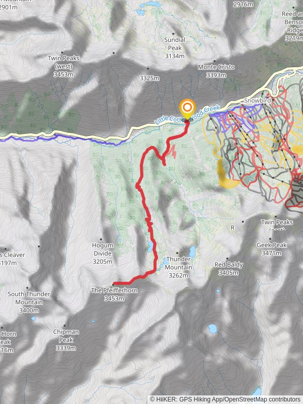
The Pfeifferhorn, Gloria Falls via White Pine Trail
Uinta-Wasatch-Cache National Forest · Salt Lake County, Utah
16.4 km
~1 day 0 hrs
1316 m
“Embark on a rewarding hike through White Pine Trail to The Pfeifferhorn, featuring stunning views and historical intrigue.”
Starting your adventure near Salt Lake County, Utah, the trailhead for The Pfeifferhorn and Gloria Falls via White Pine Trail is easily accessible by car. If you're using public transport, you can take a bus to the White Pine Trailhead parking lot, located just off Little Cottonwood Canyon Road. This is a popular starting point for many hikers, so arriving early is recommended to secure a parking spot.### Initial Ascent and White Pine Lake
The trail begins with a steady ascent through a dense forest of pine and aspen trees. Over the first 3 miles (approximately 4.8 km), you'll gain about 1,000 feet (305 meters) in elevation. This section is well-marked and relatively straightforward, making it a good warm-up for the more challenging parts ahead. Keep an eye out for wildlife such as deer and various bird species that inhabit this area.### Gloria Falls
At around the 3-mile (4.8 km) mark, you'll reach a junction where a short detour will take you to Gloria Falls. This picturesque waterfall is a great spot for a break and some photos. The falls are particularly impressive in the spring and early summer when the snowmelt is at its peak.### Climbing to the Ridge
After visiting Gloria Falls, return to the main trail and continue your ascent. The next section is more strenuous, with a series of switchbacks that will take you up to the ridge. Over the next 2 miles (3.2 km), you'll gain another 1,500 feet (457 meters) in elevation. The trail here can be rocky and uneven, so good hiking boots are essential. As you climb, you'll be rewarded with stunning views of the surrounding peaks and valleys.### The Pfeifferhorn Summit
Reaching the ridge, you'll have a clear view of The Pfeifferhorn, also known as Little Matterhorn. The final push to the summit involves some scrambling over rocky terrain. This section is about 1 mile (1.6 km) long and gains approximately 1,000 feet (305 meters) in elevation. The summit, standing at 11,326 feet (3,452 meters), offers panoramic views of the Wasatch Range and beyond. On a clear day, you can see as far as the Great Salt Lake.### Historical Significance
The Wasatch Range has a rich history, with evidence of Native American habitation dating back thousands of years. The area was also significant during the early days of Mormon settlement in Utah. Little Cottonwood Canyon, where the trailhead is located, was a major mining area in the 19th century, and remnants of old mining operations can still be seen along the trail.### Descent and Return Loop
After soaking in the views from the summit, begin your descent. The loop trail will take you down a different path, offering new scenery and perspectives. The descent is steep in places, so trekking poles can be helpful. Over the next 4 miles (6.4 km), you'll lose about 2,500 feet (762 meters) in elevation as you make your way back to the forested area near White Pine Lake.### Final Stretch
The final stretch of the trail is a gentle descent through the forest, bringing you back to the trailhead. This section is about 2 miles (3.2 km) long and relatively easy, allowing you to cool down and reflect on the day's adventure. ### Navigation Tools
For navigation, it's highly recommended to use HiiKER, which provides detailed maps and real-time updates on trail conditions. This will help ensure you stay on the right path and can enjoy your hike without any unexpected detours.This trail offers a mix of challenging climbs, stunning natural beauty, and a touch of historical intrigue, making it a rewarding experience for any hiker.
Reviews
User comments, reviews and discussions about the The Pfeifferhorn, Gloria Falls via White Pine Trail, Utah.
4.0
average rating out of 5
11 rating(s)
Loading reviews...


