Download
Preview
Add to list
More
8.2 km
~2 hrs 52 min
738 m
Loop
“Embark on the Catherines Pass Trail and Mount Millicent Loop for stunning views, rich history, and moderate challenge.”
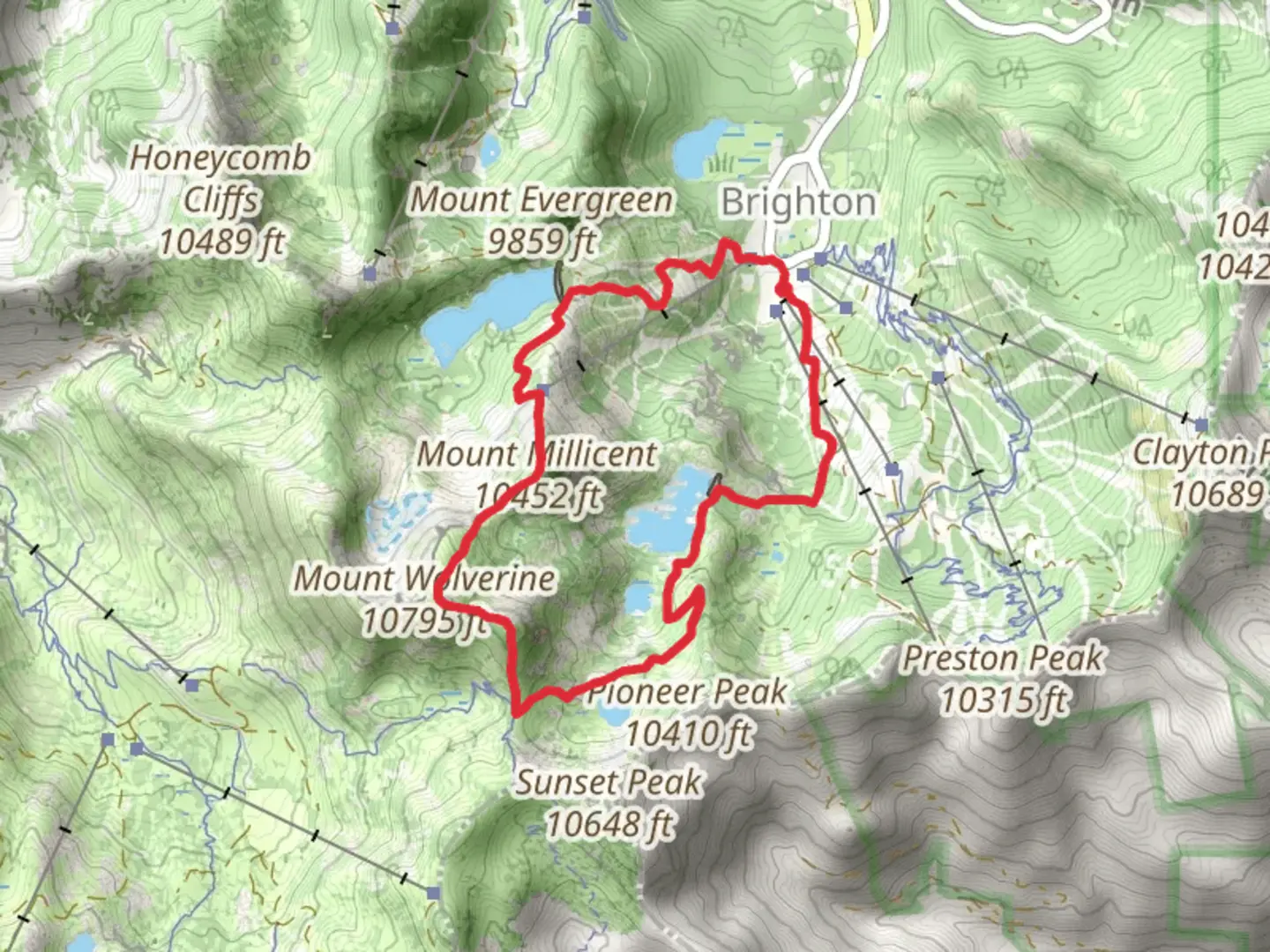
Starting your adventure near Salt Lake County, Utah, the Catherines Pass Trail and Mount Millicent Loop offers an invigorating 8 km (5 miles) journey with an elevation gain of approximately 700 meters (2,300 feet). This loop trail is rated as medium difficulty, making it suitable for hikers with some experience.
Getting There To reach the trailhead, you can drive or use public transport. If driving, head towards the Brighton Ski Resort area, which is a well-known landmark. The trailhead is located near the resort, and ample parking is available. For those using public transport, take a bus to the Brighton Ski Resort stop. From there, it's a short walk to the trailhead.
Trail Overview The trail begins with a steady ascent through a lush forest of aspen and pine trees. Early in the hike, you'll encounter a series of switchbacks that help you gain elevation quickly. After about 1.5 km (1 mile), you'll reach a more open area where the trees thin out, offering your first panoramic views of the surrounding mountains.
Key Landmarks and Points of Interest #### Catherines Pass At approximately 3 km (1.9 miles) into the hike, you'll arrive at Catherines Pass. This is a great spot to take a break and soak in the views of the Albion Basin below. The pass itself is a natural saddle between two peaks and offers a stunning vantage point for photography.
#### Mount Millicent Continuing from Catherines Pass, the trail becomes steeper as you make your way towards Mount Millicent. The final push to the summit involves some rock scrambling, so be prepared for a bit of a challenge. Once at the top, you'll be rewarded with 360-degree views of the Wasatch Range. This is the highest point of the hike, and the elevation gain from the trailhead to the summit is about 700 meters (2,300 feet).
Flora and Fauna The trail is rich in biodiversity. During the summer months, you'll find a variety of wildflowers, including Indian paintbrush, lupine, and columbine. Wildlife is also abundant; keep an eye out for mule deer, marmots, and various bird species such as the Clark's nutcracker and the mountain bluebird.
Historical Significance The area around Catherines Pass and Mount Millicent has a rich history. It was originally used by Native American tribes for hunting and gathering. In the late 19th and early 20th centuries, the region saw a surge in mining activity, remnants of which can still be seen in the form of old mining equipment and abandoned cabins along the trail.
Navigation and Safety Given the elevation and the potential for sudden weather changes, it's crucial to be prepared. Use HiiKER to download the trail map and keep track of your progress. The trail is well-marked, but having a reliable navigation tool will ensure you stay on course. Always carry sufficient water, snacks, and layers of clothing to adapt to changing conditions.
Completing the Loop After summiting Mount Millicent, the trail descends gradually, looping back towards the Brighton Ski Resort. The descent offers a different perspective of the landscape, with more opportunities to spot wildlife and enjoy the serene environment. The entire loop takes about 4-6 hours to complete, depending on your pace and the number of stops you make.
This trail offers a perfect blend of natural beauty, physical challenge, and historical intrigue, making it a must-do for any hiking enthusiast visiting the Salt Lake County area.

What to expect?
Activity types
Comments and Reviews
User comments, reviews and discussions about the Catherines Pass Trail and Mount Millicent Loop, Utah.
4.62
average rating out of 5
13 rating(s)