Download
Preview
Add to list
More
16.0 km
~4 hrs 14 min
624 m
Point-to-Point
“Embark on the Poison Spider and Portal Trail for stunning vistas, historical intrigue, and a challenging adventure.”
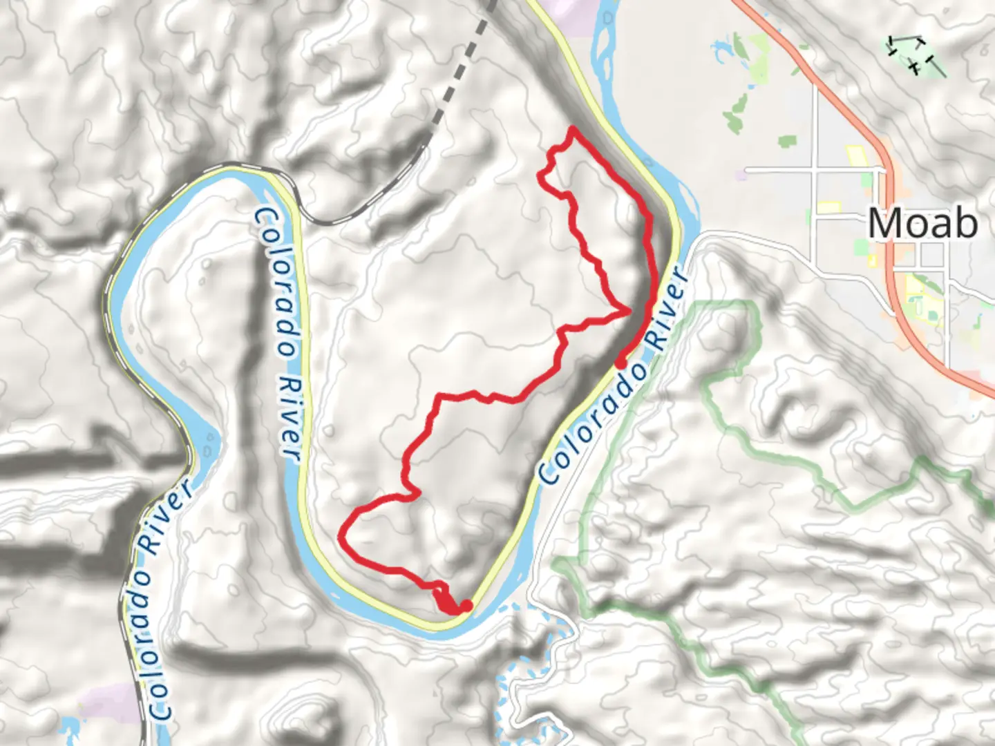
Starting near Grand County, Utah, the Poison Spider and Portal Trail is a point-to-point hike that spans approximately 16 kilometers (10 miles) with an elevation gain of around 600 meters (1,970 feet). This trail is rated as medium difficulty and offers a mix of challenging terrain, stunning vistas, and historical significance.### Getting There To reach the trailhead, you can drive or use public transport. If driving, head towards the Poison Spider Mesa Trailhead, located near the intersection of Potash Road and Poison Spider Mesa Road. For those using public transport, the nearest significant landmark is the town of Moab, Utah. From Moab, you can take a taxi or rideshare service to the trailhead, which is about a 20-minute drive.### Trail Overview The trail begins with a steady ascent, offering panoramic views of the Colorado River and the surrounding canyonlands. The initial 3 kilometers (1.9 miles) involve a climb of about 200 meters (656 feet), so be prepared for a bit of a workout right from the start. As you ascend, you'll pass through a landscape dotted with juniper and pinyon pine trees, providing occasional shade and a break from the sun.### Significant Landmarks Around the 5-kilometer (3.1-mile) mark, you'll encounter the first significant landmark: the Poison Spider Arch. This natural sandstone arch is a great spot for photos and a brief rest. Continuing on, the trail levels out somewhat, offering a mix of slickrock and sandy paths. Keep an eye out for ancient petroglyphs etched into the rock faces, remnants of the Native American tribes that once inhabited this region.### Wildlife and Flora The area is home to a variety of wildlife, including desert bighorn sheep, lizards, and a range of bird species such as ravens and red-tailed hawks. The flora is equally diverse, with blooming cacti and wildflowers adding splashes of color to the otherwise arid landscape.### Navigation and Safety Navigating the Poison Spider and Portal Trail can be challenging due to its rugged terrain and occasional lack of clear markers. It's highly recommended to use the HiiKER app for real-time navigation and trail updates. Make sure to carry plenty of water, as the desert environment can be extremely dehydrating, especially during the summer months.### Historical Significance The trail also holds historical significance. The area was once a hub for uranium mining in the mid-20th century, and you may come across old mining equipment and abandoned shafts along the way. These relics serve as a reminder of the region's industrial past and the boom-and-bust cycles that have shaped its history.### Final Stretch As you approach the final 3 kilometers (1.9 miles), the trail descends sharply towards the Portal Trailhead. This section is particularly steep and rocky, requiring careful footing. The descent offers breathtaking views of the Moab Valley and the La Sal Mountains in the distance.### Ending Point The trail concludes near the Portal Trailhead, close to the Colorado River. From here, you can either arrange for a pickup or hike back to the starting point if you're up for an additional challenge. The nearest significant landmark for pickup is the Poison Spider Bicycles shop in Moab, a convenient spot to end your adventure and perhaps grab a well-deserved meal.This hike offers a rewarding blend of natural beauty, historical intrigue, and physical challenge, making it a must-do for any avid hiker visiting the Grand County area.

What to expect?
Activity types
Comments and Reviews
User comments, reviews and discussions about the Poison Spider and Portal Trail, Utah.
4.59
average rating out of 5
17 rating(s)