Download
Preview
Add to list
More
31.6 km
~1 day 4 hrs
1653 m
Out and Back
“Embark on a 32-km, moderately challenging hike through lush forests and historic landmarks in Utah's Mueller Park.”
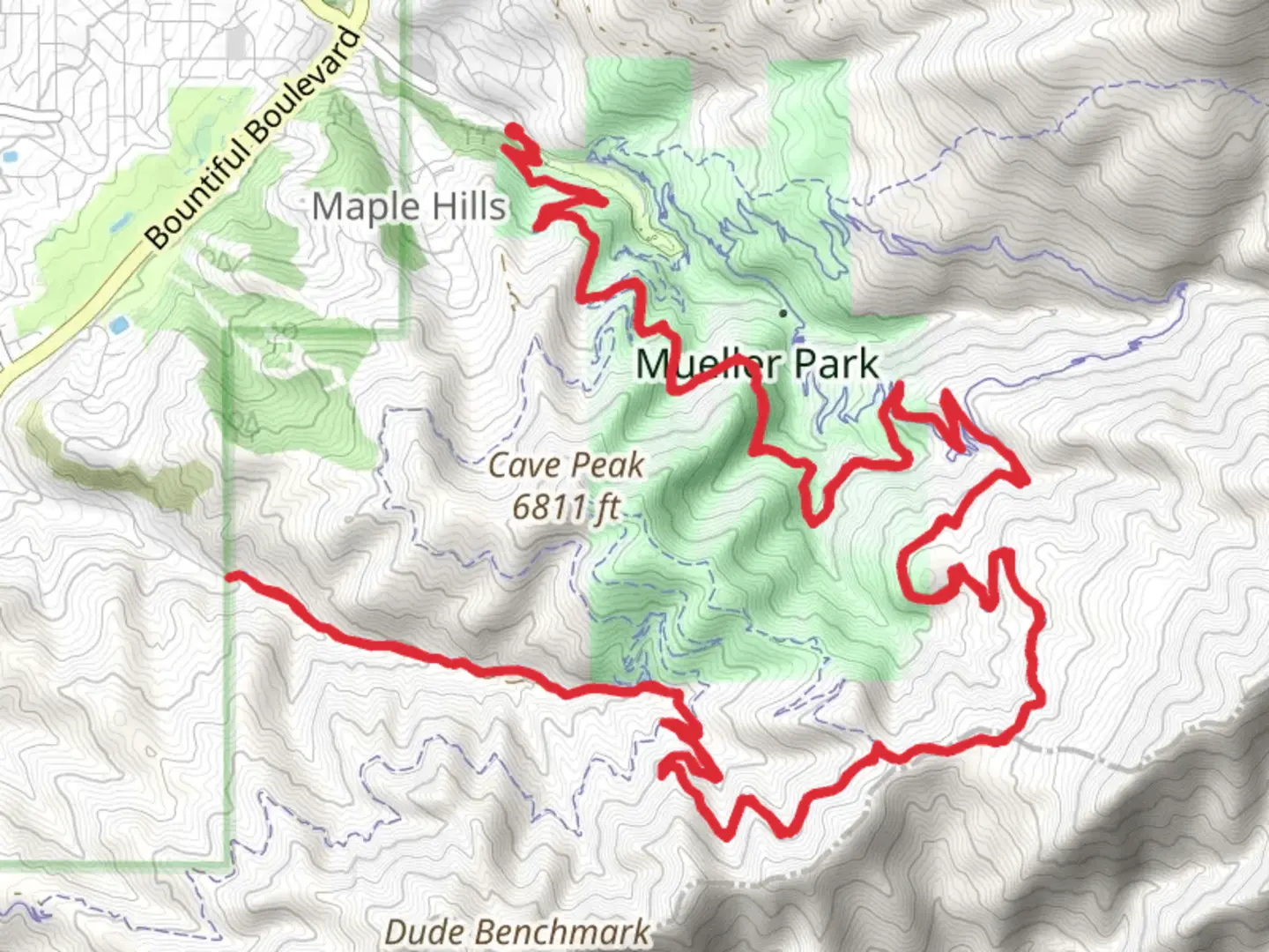
Starting near Davis County, Utah, the Mueller Park and Canyon Creek trail offers a rewarding out-and-back adventure spanning approximately 32 kilometers (20 miles) with an elevation gain of around 1600 meters (5250 feet). This trail is rated as medium difficulty, making it suitable for moderately experienced hikers.
Getting There To reach the trailhead, you can drive or use public transportation. If driving, head towards the Mueller Park Picnic Area, located near Bountiful, Utah. The nearest significant landmark is the Bountiful Ridge Golf Course. For those using public transport, take a bus to Bountiful and then a taxi or rideshare service to the picnic area.
Trail Overview The trail begins at the Mueller Park Picnic Area, where you can find ample parking and restroom facilities. The initial section of the trail is relatively gentle, winding through a lush forest of oak, maple, and pine trees. This part of the trail is well-shaded, making it a pleasant start, especially during the warmer months.
Key Landmarks and Sections - **Elephant Rock (4.8 km / 3 miles in)**: One of the first significant landmarks you'll encounter is Elephant Rock. This large rock formation offers a great spot for a break and provides stunning views of the surrounding valleys and mountains. The elevation gain to this point is about 300 meters (1000 feet).
- Rudy's Flat (8 km / 5 miles in): Continuing from Elephant Rock, the trail becomes steeper as you approach Rudy's Flat. This area is a popular camping spot and offers panoramic views of the Great Salt Lake and the Wasatch Mountains. By the time you reach Rudy's Flat, you will have gained approximately 600 meters (2000 feet) in elevation.
- North Canyon Trail Junction (12.8 km / 8 miles in): As you proceed, you'll come to a junction with the North Canyon Trail. This is a good point to check your progress using the HiiKER app. The trail here is well-marked, but it's always good to confirm your route. The elevation gain to this point is around 1000 meters (3280 feet).
- Canyon Creek (16 km / 10 miles in): The trail culminates at Canyon Creek, a serene spot perfect for a longer rest or even an overnight camp. The total elevation gain to this point is about 1600 meters (5250 feet). The creek area is rich in wildlife, including deer, various bird species, and occasionally, black bears. Always practice safe wildlife interaction protocols.
Historical Significance The region around Mueller Park and Canyon Creek has a rich history. Originally inhabited by the indigenous Ute tribes, the area later became a significant route for early Mormon settlers in the 19th century. The trail itself has been used for decades by locals for recreation and as a means to connect with the natural beauty of the Wasatch Range.
Flora and Fauna The trail offers a diverse range of flora and fauna. In the lower elevations, you'll find dense forests of oak and maple, which give way to pine and fir trees as you ascend. Wildflowers are abundant in the spring and early summer, adding vibrant colors to the landscape. Wildlife sightings are common, so keep an eye out for deer, foxes, and a variety of bird species.
Preparation and Safety Given the trail's length and elevation gain, it's crucial to be well-prepared. Carry sufficient water, snacks, and a first-aid kit. Weather can change rapidly in the mountains, so bring layers and rain gear. Navigation tools like the HiiKER app are essential for staying on track, especially at trail junctions.
This trail offers a mix of natural beauty, historical significance, and a moderate challenge, making it a rewarding experience for those who undertake it.

What to expect?
Activity types
Comments and Reviews
User comments, reviews and discussions about the Mueller Park and Canyon Creek, Utah.
4.57
average rating out of 5
23 rating(s)