Download
Preview
Add to list
More
811.4 km
~55 days
33734 m
Multi-Day
“Embark on the GR 11, a captivating odyssey from Mediterranean serenity to the wild Atlantic, through Spain's majestic Pyrenees.”
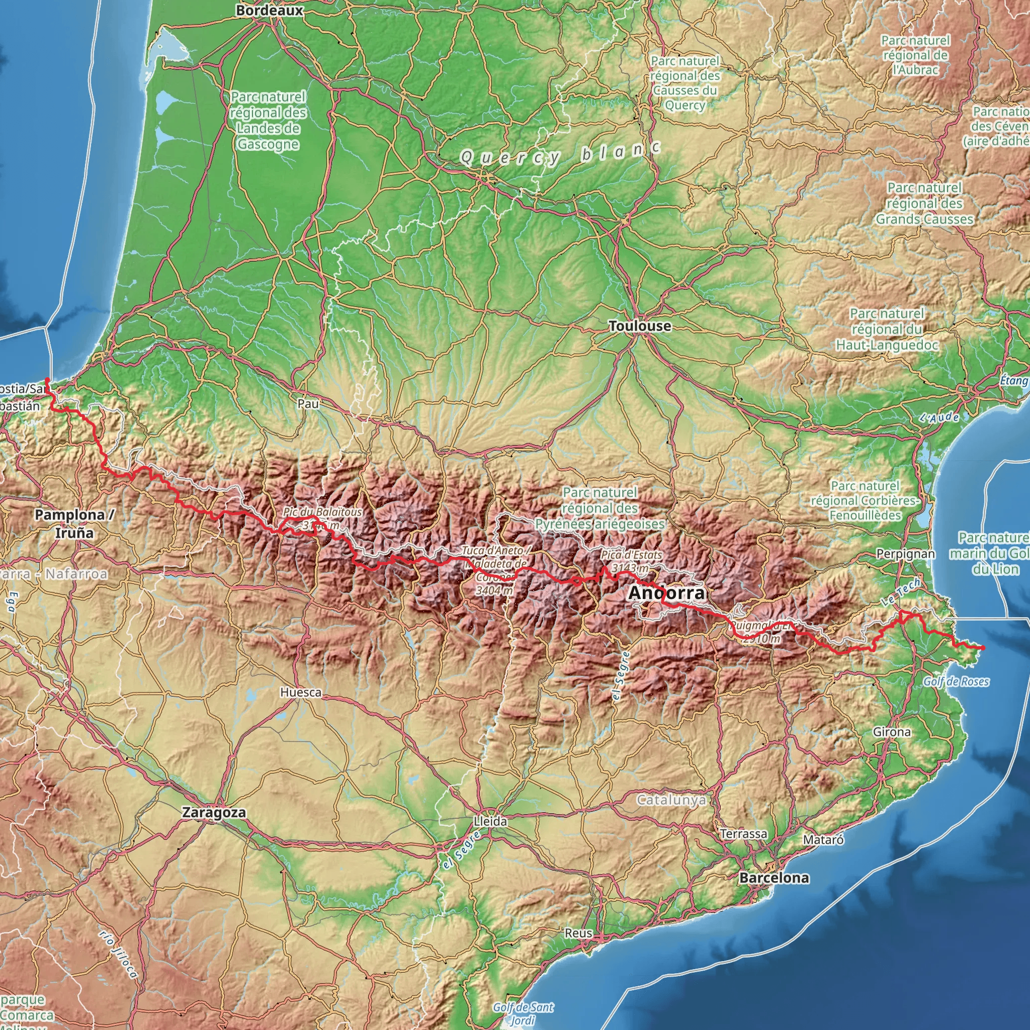
Spanning approximately 811 kilometers (504 miles) and with an elevation gain of around 33,700 meters (110,560 feet), the GR 11 trail, also known as the Trans-Pyrenean trail, is a challenging yet rewarding trek that traverses the entirety of the Spanish Pyrenees from the Mediterranean Sea to the Atlantic Ocean. Starting near the picturesque town of Cadaqués, Spain, the trail head is accessible by both public transport and car. For those opting for public transport, buses from Barcelona and Girona can drop you near the starting point, while drivers will find parking available in the town.
Getting Started: The Mediterranean Coast
The journey begins near the Salvador Dali's beloved Cadaqués, where the Mediterranean's azure waters serve as a stunning backdrop. The initial stages of the trail are characterized by the rugged coastline and the gradual ascent into the Albera Range. Hikers will witness a dramatic change in landscape as they move from sea level to higher elevations.
Ascending the Pyrenees
As the trail progresses, it weaves through the Aigüestortes i Estany de Sant Maurici National Park, offering views of glacial lakes and towering peaks. The ascent through this area is steep, with some sections requiring a steady pace and careful footing. The park is a highlight for many, with its rich biodiversity including the Pyrenean chamois, marmots, and golden eagles.
Historical Landmarks and Culture
The GR 11 not only offers natural wonders but also passes through regions steeped in history. Ancient monasteries, such as the Monastery of Sant Pere de Rodes, and remnants of past civilizations are scattered along the path. The trail also cuts through the Ordesa y Monte Perdido National Park, a UNESCO World Heritage Site, where hikers can explore the deep canyons and limestone cliffs that have been shaped over millions of years.
Challenging Terrain and Climate Variability
The trail's difficulty is not to be underestimated, with some sections featuring rugged, rocky paths and others with smoother forest trails. The elevation gain is significant, and the weather can be unpredictable, ranging from hot summer temperatures to cold, snowy conditions at higher altitudes. Hikers should be prepared for all weather scenarios and carry appropriate gear.
Navigation and Planning
For navigation, HiiKER is an invaluable tool for planning and staying on track throughout the journey. It provides detailed maps and information on the trail, which is essential given the trail's length and complexity. Hikers should plan their stops carefully, as there are stretches with limited access to amenities.
End of the Trail: The Atlantic Ocean
The trail concludes at the Cap de Higuer near Hondarribia on the Bay of Biscay, where the Atlantic Ocean's waves signal the end of an epic journey. The sense of accomplishment upon reaching this point is immense, as hikers reflect on the diverse landscapes, cultures, and challenges they've encountered along the way.
Preparation and Safety
Given the trail's difficulty, thorough preparation is crucial. Hikers should ensure they are physically fit and have the necessary equipment for a long-distance trek. It's also important to carry a first-aid kit, sufficient food and water supplies, and a means of communication in case of emergencies. Always inform someone of your itinerary and expected return time.
Conclusion
The GR 11 is a trail of contrasts, from the warm Mediterranean coast to the rugged high mountains of the Pyrenees, and finally to the cool Atlantic shores. It offers an immersive experience into the natural beauty and cultural heritage of Spain, challenging hikers to push their limits while rewarding them with breathtaking views and a profound sense of achievement.
Comments and Reviews
User comments, reviews and discussions about the GR 11, Spain.
4.86
average rating out of 5
14 rating(s)

