Dial Mountain, Nippletop and Mount Colvin Trail via Elk Lake- Marcy Trail
Download
Preview
Add to list
More
46.4 km
~2 day
2792 m
Out and Back
“Embark on a rugged adventure through breathtaking peaks and diverse ecosystems in the Adirondack High Peaks.”
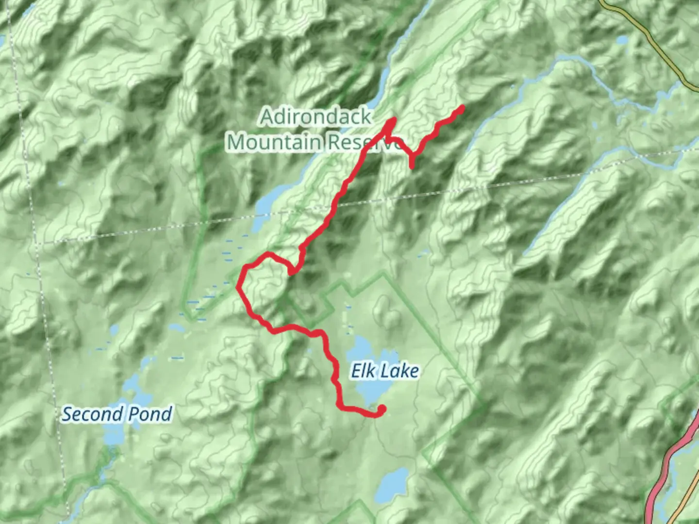
The Dial Mountain, Nippletop, and Mount Colvin Trail via Elk Lake-Marcy Trail is a challenging yet rewarding adventure nestled in the heart of the Adirondack High Peaks region. This out-and-back trail spans approximately 46 kilometers (about 28.5 miles) with an elevation gain of around 2,700 meters (approximately 8,860 feet), making it a formidable journey for seasoned hikers.
Getting There
The trailhead is located near Essex County, New York. For those driving, the most convenient access point is via Elk Lake Road, which is off Route 73. Parking is available at the Elk Lake parking area, but it can fill up quickly, especially during peak hiking seasons. If you're relying on public transport, the nearest major hub is Lake Placid, from where you can take a taxi or arrange a shuttle service to the trailhead.
Trail Overview
The trail begins with a steady ascent through dense hardwood forests, offering a serene start to your journey. As you progress, the path becomes steeper and more rugged, with rocky sections that require careful navigation. Utilizing HiiKER for navigation is highly recommended to ensure you stay on track.
#### Dial Mountain
At approximately 11 kilometers (about 6.8 miles) into the hike, you'll reach the summit of Dial Mountain. The elevation here is around 1,200 meters (3,937 feet), providing panoramic views of the surrounding peaks and valleys. The summit is marked by a small cairn, and on clear days, you can see the Great Range in the distance.
#### Nippletop Mountain
Continuing onward, the trail leads you to Nippletop Mountain, which stands at an elevation of about 1,350 meters (4,429 feet). This section of the trail is particularly steep and challenging, with an elevation gain of approximately 150 meters (492 feet) over a short distance. The summit offers breathtaking views of the Dix Range and the Ausable Lakes.
#### Mount Colvin
The final peak on this trail is Mount Colvin, located roughly 23 kilometers (14.3 miles) from the trailhead. At an elevation of 1,243 meters (4,078 feet), Mount Colvin provides stunning vistas of the surrounding wilderness, including the iconic Indian Head and Fish Hawk Cliffs. This area is rich in history, named after Verplanck Colvin, a prominent surveyor who played a crucial role in mapping the Adirondacks in the late 19th century.
Nature and Wildlife
The trail traverses a diverse range of ecosystems, from lush hardwood forests to alpine zones. Keep an eye out for local wildlife, including white-tailed deer, black bears, and a variety of bird species. The area is also home to unique flora, such as the rare alpine azalea and the vibrant red trillium.
Important Considerations
Given the trail's difficulty, it's essential to be well-prepared. Ensure you have adequate supplies, including water, food, and appropriate clothing for changing weather conditions. The trail can be muddy and slippery, especially after rain, so sturdy hiking boots are a must. Additionally, cell service is limited, so downloading offline maps on HiiKER before your hike is advisable.
This trail offers a challenging yet unforgettable experience, showcasing the rugged beauty and rich history of the Adirondack High Peaks.

What to expect?
Activity types
Comments and Reviews
User comments, reviews and discussions about the Dial Mountain, Nippletop and Mount Colvin Trail via Elk Lake- Marcy Trail, New York.
average rating out of 5
0 rating(s)