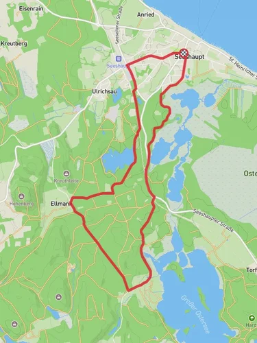
Ameissee and Rohrmoser Weiher via Kleiner Lauterbacher Waldweg and Osterseen Wanderweg
13.6 km
~3 hrs 8 min
255 m
“Discover Weilheim-Schongau's 14 km loop: scenic lakes, serene forests, historical sites, and moderate challenges.”
Starting near the picturesque town of Weilheim-Schongau in Germany, this 14 km (8.7 miles) loop trail offers a delightful mix of natural beauty and moderate physical challenge, with an elevation gain of around 200 meters (656 feet). The trailhead is conveniently accessible by both car and public transport. If driving, you can park near the Weilheim-Schongau area. For those using public transport, take a train to Weilheim (Oberbay) station and then a local bus or taxi to the trailhead.
### Trail Overview
The trail begins with a gentle ascent through the Kleiner Lauterbacher Waldweg, a serene forest path that sets the tone for the hike. The initial 3 km (1.9 miles) will take you through dense woodland, where the air is filled with the scent of pine and the sounds of chirping birds. Keep an eye out for deer and other small wildlife that are often seen in this area.
### Ameissee and Rohrmoser Weiher
Around the 4 km (2.5 miles) mark, you'll reach Ameissee, a tranquil lake surrounded by lush greenery. This is a great spot to take a short break and enjoy the peaceful surroundings. Continuing on, you'll soon arrive at Rohrmoser Weiher, another beautiful body of water. Both lakes are perfect for bird-watching, so bring your binoculars if you're a bird enthusiast.
### Osterseen Wanderweg
The trail then merges with the Osterseen Wanderweg, leading you through a series of smaller lakes and ponds. This section is particularly scenic, with clear waters reflecting the sky and surrounding foliage. The path here is relatively flat, making it a pleasant walk. You'll cover approximately 5 km (3.1 miles) along this stretch, with minimal elevation change.
### Historical Significance
As you hike, you'll be traversing a region rich in history. The area around Weilheim-Schongau has been inhabited since Roman times, and you may come across ancient ruins and historical markers along the way. The Osterseen lakes themselves have been a source of inspiration for local folklore and legends, adding a mystical element to your journey.
### Final Stretch
The last 2 km (1.2 miles) of the trail will take you back through the Kleiner Lauterbacher Waldweg, completing the loop. This section involves a gentle descent, allowing you to cool down as you make your way back to the starting point.
### Navigation and Safety
For navigation, it's highly recommended to use the HiiKER app, which provides detailed maps and real-time updates. The trail is well-marked, but having a reliable navigation tool will ensure you stay on track. Always carry enough water, snacks, and a basic first-aid kit. Weather can change rapidly, so check the forecast and dress in layers.
This trail offers a perfect blend of natural beauty, moderate physical challenge, and historical intrigue, making it a rewarding experience for any hiker.
Reviews
User comments, reviews and discussions about the Ameissee and Rohrmoser Weiher via Kleiner Lauterbacher Waldweg and Osterseen Wanderweg, Germany.
0.0
average rating out of 5
0 rating(s)


