Download
Preview
Add to list
More
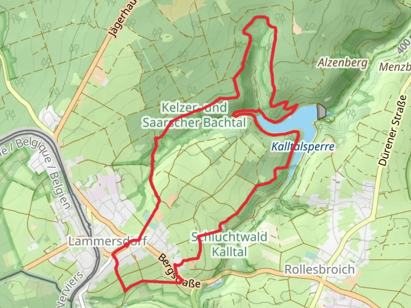
11.5 km
~2 hrs 41 min
232 m
Loop
“Discover the enchanting Lammersdorf and Kalltalsperre Loop, a 12 km trail blending nature, wildlife, and history.”
Starting near the Städteregion Aachen in Germany, the Lammersdorf and Kalltalsperre Loop is a captivating 12 km (7.5 miles) trail with an elevation gain of approximately 200 meters (656 feet). This loop trail is rated as medium difficulty, making it suitable for moderately experienced hikers.### Getting There To reach the trailhead, you can drive or use public transport. If driving, you can park near the village of Lammersdorf, which is well-signposted and has ample parking facilities. For those using public transport, take a train to Aachen Hauptbahnhof and then a bus to Lammersdorf. The bus stop is conveniently located near the trailhead.### Trail Overview The trail begins in the quaint village of Lammersdorf, known for its charming half-timbered houses and serene atmosphere. As you set off, you'll quickly find yourself immersed in lush forests and rolling hills. The initial part of the trail is relatively flat, allowing you to ease into the hike.### Key Landmarks and Points of Interest - Lammersdorf Village: The starting point itself is a picturesque village worth exploring. Take a moment to admire the traditional architecture and perhaps grab a coffee at a local café. - Kalltalsperre Reservoir: About 5 km (3.1 miles) into the hike, you'll reach the Kalltalsperre Reservoir. This man-made lake is a significant landmark, offering stunning views and a peaceful spot for a short break. The reservoir was constructed in the early 20th century to supply water to the surrounding areas. - Forests and Wildlife: The trail meanders through dense forests, home to a variety of wildlife including deer, foxes, and numerous bird species. Keep your eyes peeled for these creatures, especially in the early morning or late afternoon. - Historical Significance: The region around Aachen has a rich history, dating back to Roman times. While the trail itself doesn't pass any specific historical sites, the area is steeped in history, and you may come across informational plaques detailing the local heritage.### Trail Navigation The trail is well-marked with signs and markers, but it's always a good idea to have a reliable navigation tool. HiiKER is an excellent app for this purpose, providing detailed maps and real-time tracking to ensure you stay on course.### Elevation and Terrain The elevation gain of 200 meters (656 feet) is spread out over the 12 km (7.5 miles), making for a moderate climb. The terrain varies from well-maintained paths to more rugged sections, so sturdy hiking boots are recommended. The most challenging part of the hike comes around the 8 km (5 miles) mark, where a steeper ascent takes you through a dense forest area.### Flora and Fauna The trail is a haven for nature lovers. In spring and summer, the forest floor is carpeted with wildflowers, while autumn brings a stunning display of fall foliage. The diverse ecosystem supports a wide range of plant and animal life, making every hike a unique experience.### Final Stretch As you loop back towards Lammersdorf, the trail descends gently, offering panoramic views of the surrounding countryside. This final stretch is a great opportunity to reflect on the hike and enjoy the natural beauty of the region.Whether you're a seasoned hiker or looking for a moderately challenging trail, the Lammersdorf and Kalltalsperre Loop offers a rewarding experience with its blend of natural beauty, wildlife, and historical context.

What to expect?
Activity types
Comments and Reviews
User comments, reviews and discussions about the Lammersdorf and Kalltalsperre Loop, Germany.
5.0
average rating out of 5
3 rating(s)