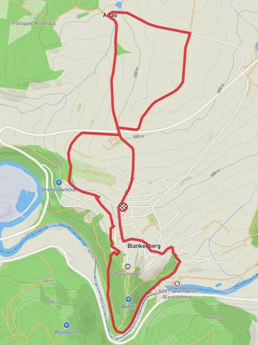
12.8 km
~3 hrs 10 min
365 m
“Explore Saale-Orla-Kreis's 13 km loop, blending scenic rivers, historic ruins, and vibrant forests.”
Starting near the picturesque region of Saale-Orla-Kreis in Germany, this 13 km (8 miles) loop trail offers a delightful mix of natural beauty and historical intrigue. With an elevation gain of around 300 meters (984 feet), the trail is rated as medium difficulty, making it accessible for most hikers with a moderate level of fitness.### Getting There
To reach the trailhead, you can either drive or use public transport. If you're driving, set your GPS to Saale-Orla-Kreis, Germany. For those opting for public transport, the nearest major town is Pößneck, which is well-connected by train. From Pößneck, you can take a local bus to the trailhead area.### Trail Navigation
For navigation, I highly recommend using the HiiKER app, which provides detailed maps and real-time updates to ensure you stay on track.### Trail Highlights#### Saale River
The trail initially follows the scenic Saale River, offering stunning views of the water and surrounding landscapes. This section is relatively flat, making it a good warm-up for the more challenging parts ahead. Keep an eye out for various bird species that frequent the riverbanks, including kingfishers and herons.#### Historical Significance
As you continue, you'll come across several historical landmarks. One notable site is the ruins of the Orla Castle, which dates back to the medieval period. The castle offers a glimpse into the region's rich history and provides a great spot for a short break and some photographs.#### Forested Sections
The trail then meanders through dense forests, where the elevation gain becomes more noticeable. This part of the hike is particularly beautiful in the autumn when the leaves change color. The forest is home to a variety of wildlife, including deer and wild boar, so keep your eyes peeled.#### Haara Wanderweg
Around the halfway point, you'll transition onto the Haara Wanderweg. This section is known for its rolling hills and panoramic views of the surrounding countryside. The elevation gain here is more gradual, making it a bit easier on the legs. There are several benches along this part of the trail where you can rest and take in the views.### Practical Information
- Water and Snacks: There are no water sources along the trail, so make sure to bring enough water and snacks to keep your energy levels up.
- Footwear: Given the mixed terrain, sturdy hiking boots are recommended.
- Weather: The trail can be muddy after rain, so check the weather forecast before heading out and dress accordingly.### Wildlife and Flora
The trail is rich in biodiversity. In addition to the birds and mammals, you'll find a variety of plant species, including wildflowers in the spring and summer. The forested areas are dominated by oak and beech trees, providing ample shade during the warmer months.### Final Stretch
The last part of the trail loops back towards the Saale River, offering a gentle descent and a relaxing end to your hike. This section is less strenuous, allowing you to cool down and enjoy the final views of the river and surrounding landscapes.By the time you complete the loop, you'll have experienced a diverse range of environments, from riverside paths to forested hills, all while soaking in the historical and natural beauty of the Saale-Orla-Kreis region.
Reviews
User comments, reviews and discussions about the Saale via Saale Orla Weg and Haara Wanderweg, Germany.
5.0
average rating out of 5
2 rating(s)
Loading reviews...


