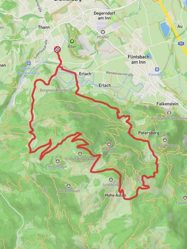
9.8 km
~2 hrs 20 min
237 m
“Immerse in Bavaria's beauty with the moderately challenging 10 km Oel Check Trail near Rosenheim.”
Starting near the picturesque town of Rosenheim, Germany, the Oel Check Trail is a delightful 10 km (6.2 miles) loop that offers a moderate challenge with an elevation gain of approximately 200 meters (656 feet). This trail is perfect for those looking to immerse themselves in the natural beauty of Bavaria while enjoying a bit of a workout.
### Getting There To reach the trailhead, you can either drive or use public transport. If you're driving, set your GPS to the nearest known address: Mangfallpark, Rosenheim. There is ample parking available in the vicinity. For those using public transport, Rosenheim is well-connected by train. From the Rosenheim train station, you can take a local bus to Mangfallpark, which is just a short walk from the trailhead.
### Trail Overview The Oel Check Trail begins with a gentle ascent through a mixed forest, where you'll be greeted by the soothing sounds of birds and the rustling of leaves. The initial 2 km (1.2 miles) of the trail are relatively easy, making it a good warm-up for the more challenging sections ahead.
### Key Landmarks and Nature As you progress, you'll come across the first significant landmark, the Mangfall River, around the 3 km (1.9 miles) mark. This river is not only a beautiful sight but also historically significant as it has been a vital water source for the region for centuries. Take a moment to enjoy the serene views and perhaps snap a few photos.
Continuing along the trail, you'll encounter a series of gentle hills. The elevation gain becomes more noticeable here, but the well-maintained path makes it manageable for most hikers. Around the 5 km (3.1 miles) point, you'll reach the highest elevation of the trail, offering panoramic views of the surrounding Bavarian countryside. This is an excellent spot for a short break and to take in the scenery.
### Flora and Fauna The trail is rich in biodiversity. Keep an eye out for various species of birds, including woodpeckers and finches. The forested areas are home to deer and, occasionally, wild boar. The flora is equally impressive, with a mix of deciduous and coniferous trees, as well as seasonal wildflowers that add a splash of color to the landscape.
### Historical Significance The region around Rosenheim has a rich history dating back to Roman times. While the trail itself is primarily a natural experience, the proximity to Rosenheim means you can easily explore historical sites in the town before or after your hike. The town's history as a trading hub is evident in its well-preserved architecture and local museums.
### Navigation and Safety For navigation, it's highly recommended to use the HiiKER app, which provides detailed maps and real-time updates. The trail is well-marked, but having a reliable navigation tool ensures you stay on track and can fully enjoy the experience without any worries.
### Final Stretch The last 2 km (1.2 miles) of the trail are a gentle descent back towards the trailhead. This section is particularly scenic, with open meadows and occasional glimpses of the Mangfall River. As you near the end of the loop, you'll find yourself back at Mangfallpark, where you can relax and reflect on the day's adventure.
The Oel Check Trail offers a perfect blend of natural beauty, moderate physical challenge, and a touch of historical intrigue, making it a must-visit for any hiking enthusiast in the region.
Reviews
User comments, reviews and discussions about the Oel Check Trail, Germany.
0.0
average rating out of 5
0 rating(s)


