Download
Preview
Add to list
More
16.7 km
~6 hrs 15 min
1743 m
Point-to-Point
“Embark on a thrilling alpine journey, discovering breathtaking vistas and historical trails in the Bavarian Alps.”
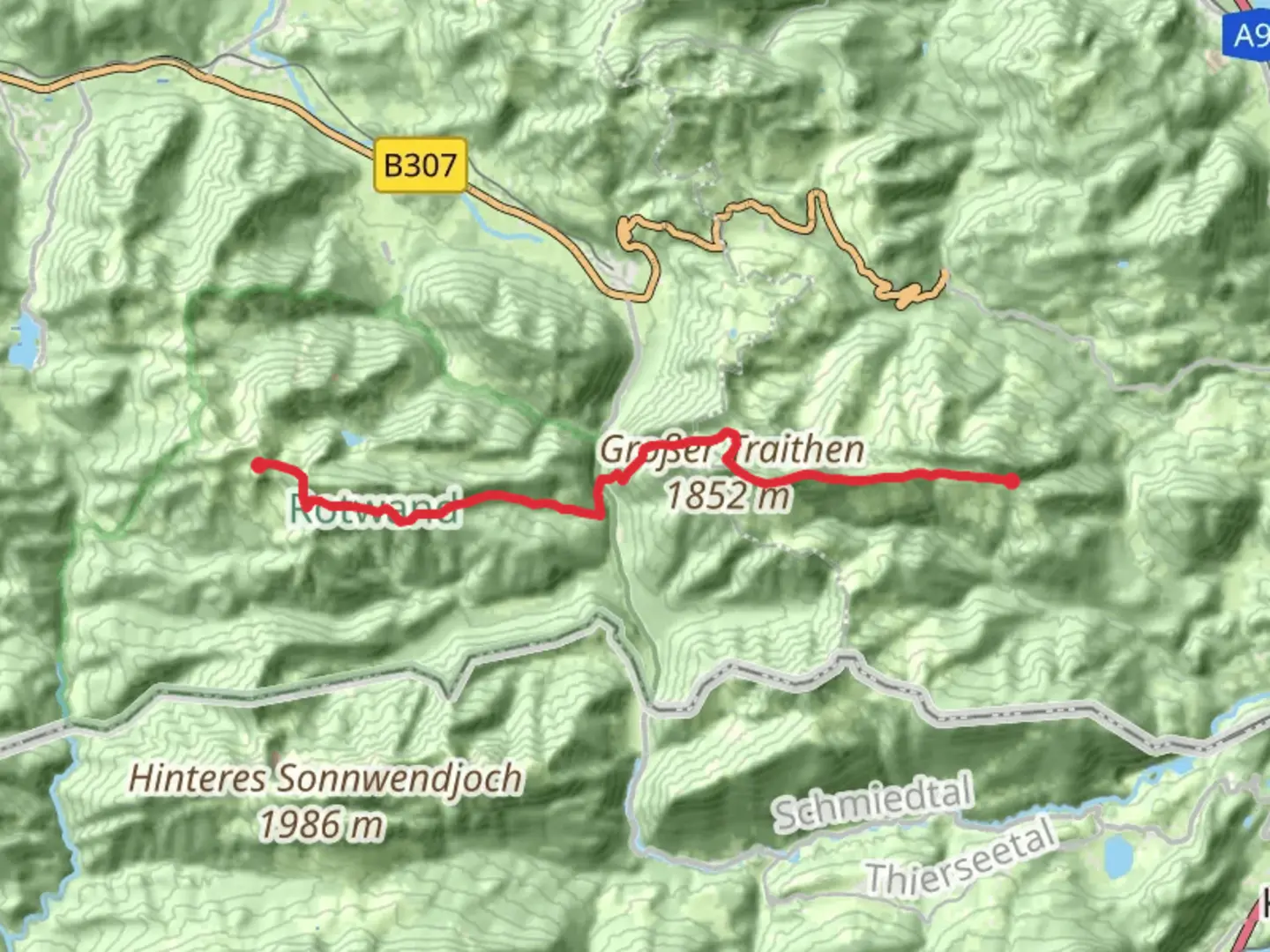
Nestled in the Bavarian Alps, the hike from Brunnsteinhaus to Rotwandhaus via Grober Traithen is a challenging yet rewarding journey through some of Germany's most stunning landscapes. This point-to-point trail stretches approximately 17 kilometers (about 10.5 miles) and involves an elevation gain of around 1,700 meters (5,577 feet), making it suitable for experienced hikers seeking a demanding adventure.
Getting There
The trailhead is conveniently located near Rosenheim, Germany. For those traveling by public transport, you can take a train to Oberaudorf, which is the nearest station. From there, a short bus ride or taxi will bring you to the starting point at Brunnsteinhaus. If you're driving, there are parking facilities available near the trailhead, but it's advisable to arrive early, especially during peak hiking seasons.
Trail Overview
The journey begins at Brunnsteinhaus, a charming mountain hut that offers a glimpse into the traditional alpine architecture of the region. As you set off, the trail ascends steadily, providing panoramic views of the surrounding valleys and peaks. The initial section is characterized by lush alpine meadows, where you might spot local wildlife such as chamois or marmots.
Grober Traithen
Approximately halfway through the hike, you'll reach Grober Traithen, a prominent peak standing at 1,852 meters (6,076 feet). This section of the trail is particularly steep and rocky, requiring careful navigation and sturdy footwear. The summit offers breathtaking vistas of the Bavarian Alps and, on clear days, you can see as far as the Austrian border. It's a perfect spot to take a break and soak in the natural beauty.
Historical Significance
The region around Grober Traithen is steeped in history. During the Middle Ages, these mountains served as natural borders and were often traversed by traders and travelers. The trails you walk today were once vital routes for commerce and communication between regions. Keep an eye out for historical markers and plaques that provide insights into the area's rich past.
Navigational Tips
Given the trail's difficulty, it's crucial to have a reliable navigation tool. HiiKER is an excellent resource for detailed maps and real-time trail updates. Ensure your device is fully charged and consider carrying a portable charger, as the trail can take a full day to complete.
Rotwandhaus
The final stretch of the hike leads you to Rotwandhaus, another picturesque mountain hut where you can rest and enjoy traditional Bavarian cuisine. The descent towards Rotwandhaus is less strenuous, allowing you to unwind and reflect on the day's adventure. The hut is also a popular spot for overnight stays, offering cozy accommodations for those wishing to extend their alpine experience.
Wildlife and Flora
Throughout the hike, you'll traverse diverse ecosystems, from dense forests to open alpine pastures. The area is home to a variety of flora, including edelweiss and alpine roses, which bloom in vibrant colors during the summer months. Birdwatchers will delight in spotting golden eagles and other native species soaring above the peaks.
This trail offers a perfect blend of natural beauty, historical intrigue, and physical challenge, making it a must-do for avid hikers exploring the Bavarian Alps.

Comments and Reviews
User comments, reviews and discussions about the Brunnsteinhaus to Rotwandhaus Walk via Grober Traithen, Germany.
average rating out of 5
0 rating(s)