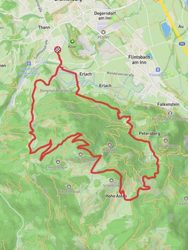
8.8 km
~2 hrs 27 min
416 m
“Explore the Bavarian Alps' natural beauty and history on a scenic, medium-difficulty 9 km loop near Rosenheim.”
Starting near the picturesque town of Rosenheim, Germany, the Brannenburg and Maximiliansweg trail offers a delightful loop of approximately 9 km (5.6 miles) with an elevation gain of around 400 meters (1,312 feet). This medium-difficulty hike is perfect for those looking to explore the Bavarian Alps' natural beauty and historical significance.
### Getting There
To reach the trailhead, you can either drive or use public transport. If driving, head towards Brannenburg, a small town located about 20 km (12.4 miles) south of Rosenheim. There are several parking options available near the trailhead. For those using public transport, take a train to Brannenburg station. From there, it's a short walk to the starting point of the hike.
### Trail Overview
The trail begins in Brannenburg, a charming town known for its traditional Bavarian architecture. As you start your hike, you'll be greeted by lush meadows and the distant sound of cowbells, a quintessential Bavarian experience. The initial part of the trail is relatively flat, making it an excellent warm-up for the more challenging sections ahead.
### Key Landmarks and Points of Interest
#### Schloss Brannenburg
Approximately 2 km (1.2 miles) into the hike, you'll come across Schloss Brannenburg, a historic castle that dates back to the 12th century. The castle offers a glimpse into the region's medieval past and provides a fantastic photo opportunity. Although the castle itself is not open to the public, the surrounding area is perfect for a short break.
#### Maximiliansweg
As you continue, you'll join the Maximiliansweg, a historic trail named after King Maximilian II of Bavaria. This section of the hike is more challenging, with a steady ascent that will take you through dense forests and rocky terrain. The elevation gain here is about 300 meters (984 feet) over a distance of 3 km (1.9 miles), so be prepared for a bit of a workout.
### Flora and Fauna
The trail is rich in biodiversity. Keep an eye out for native wildlife such as deer, foxes, and various bird species. The forested areas are home to a variety of trees, including beech, oak, and pine. During the spring and summer months, the meadows are adorned with wildflowers, adding a splash of color to your hike.
### Scenic Vistas
Around the 6 km (3.7 miles) mark, you'll reach a viewpoint that offers panoramic views of the Inn Valley and the surrounding Alps. This is one of the most rewarding parts of the hike, so take some time to soak in the scenery and perhaps enjoy a snack.
### Descending Back to Brannenburg
The final 3 km (1.9 miles) of the trail involve a gradual descent back to Brannenburg. This section is less strenuous and allows you to enjoy the serene landscape at a more relaxed pace. You'll pass through more meadows and small streams, making it a peaceful end to your hike.
### Navigation
For navigation, it's highly recommended to use the HiiKER app, which provides detailed maps and real-time updates to ensure you stay on the right path.
### Historical Significance
The region around Brannenburg has a rich history, with evidence of human settlement dating back to the Bronze Age. The Maximiliansweg itself is a testament to the area's historical importance, having been used for centuries as a trade and travel route.
This hike offers a perfect blend of natural beauty, physical challenge, and historical intrigue, making it a must-do for anyone visiting the Bavarian Alps.
Reviews
User comments, reviews and discussions about the Brannenburg and Maximiliansweg, Germany.
0.0
average rating out of 5
0 rating(s)


