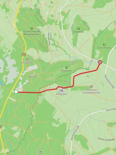
8.8 km
~2 hrs 5 min
190 m
“Explore the scenic Rhön-Grabfeld trail, rich with wildlife, history, and panoramic views.”
Nestled in the picturesque Rhön-Grabfeld region of Germany, this loop trail offers a delightful blend of natural beauty and cultural history. Spanning approximately 9 kilometers (about 5.6 miles) with an elevation gain of around 100 meters (328 feet), the trail is rated as medium difficulty, making it accessible for most hikers with a moderate level of fitness.
### Getting There
The trailhead is conveniently located near the town of Rhön-Grabfeld. If you're traveling by car, you can reach the area via the A71 motorway, exiting at Bad Neustadt an der Saale and following local roads to the trailhead. For those using public transport, the nearest major railway station is in Bad Neustadt, from where you can take a local bus or taxi to the starting point.
### Trail Highlights
#### Ostesweg Section
As you embark on the Ostesweg section, you'll be greeted by the serene landscapes typical of the Rhön Biosphere Reserve. This area is renowned for its rolling hills and open meadows, providing a habitat for a variety of wildlife, including red deer and numerous bird species. Keep an eye out for the distinctive red kite soaring above, a common sight in this region.
#### Rhoen-Rundweg Section
Transitioning onto the Rhoen-Rundweg, the trail meanders through lush forests and pastures. This section offers a gentle ascent, allowing you to enjoy panoramic views of the surrounding countryside. The trail is well-marked, but it's advisable to use the HiiKER app for navigation to ensure you stay on track.
### Points of Interest
Along the trail, you'll encounter several points of interest that reflect the area's rich history. The Rhön region has been inhabited since prehistoric times, and remnants of ancient settlements can still be found. Look out for the traditional half-timbered houses in nearby villages, which showcase the architectural style of the region.
The trail also passes near the Wasserkuppe, the highest peak in the Rhön Mountains, known for its significance in aviation history as the birthplace of gliding. While not directly on the trail, it's worth a detour if time permits.
### Flora and Fauna
The diverse ecosystems along the trail support a wide range of plant and animal life. In spring and summer, the meadows burst into color with wildflowers, attracting butterflies and bees. The forests are home to a variety of tree species, including beech and oak, providing a habitat for woodland creatures like foxes and badgers.
### Practical Information
The trail is best hiked from late spring to early autumn when the weather is mild and the paths are dry. Be sure to wear sturdy hiking boots and bring plenty of water, as there are limited facilities along the route. While the trail is generally well-maintained, some sections can be muddy after rain, so be prepared for varying trail conditions.
Whether you're a seasoned hiker or a nature enthusiast, this trail offers a rewarding experience with its blend of natural beauty, wildlife, and cultural heritage.
Reviews
User comments, reviews and discussions about the Hohe Dalle via Ostesweg and Rhoen-Rundweg, Germany.
0.0
average rating out of 5
0 rating(s)


