Download
Preview
Add to list
More
13.4 km
~3 hrs 24 min
437 m
Loop
“"Discover the Herchen Rundweg Loop: a 13 km trail of forests, meadows, history, and scenic riverbanks."”
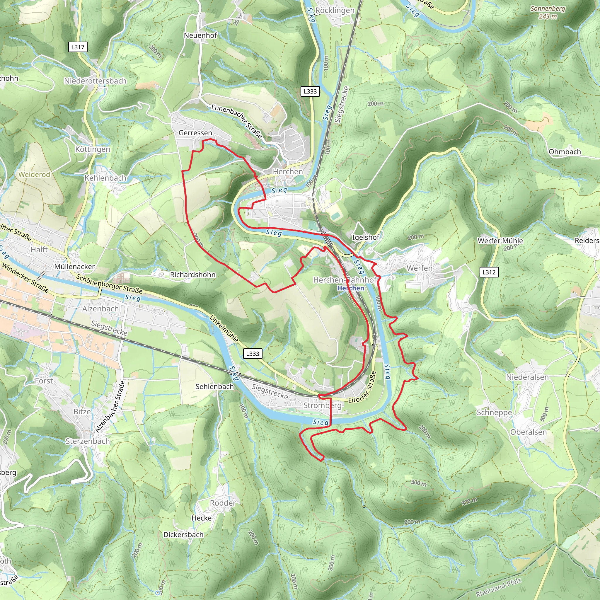
Starting near Rhein-Sieg-Kreis, Germany, the Herchen Rundweg Loop is a captivating 13 km (approximately 8 miles) trail with an elevation gain of around 400 meters (about 1,312 feet). This loop trail is rated as medium difficulty, making it suitable for moderately experienced hikers.
Getting There
To reach the trailhead, you can drive or use public transport. If driving, set your GPS to Herchen, a small village in the Rhein-Sieg-Kreis district. There is ample parking available near the village center. For those using public transport, take a train to Herchen station, which is well-connected via the regional rail network. From the station, it's a short walk to the trailhead.
Trail Overview
The Herchen Rundweg Loop offers a diverse hiking experience, weaving through dense forests, open meadows, and along the serene banks of the Sieg River. The trail is well-marked, but it's advisable to use HiiKER for navigation to ensure you stay on track.
Key Sections and Landmarks
#### Forested Ascents
The initial part of the trail takes you through lush, deciduous forests. This section involves a steady ascent, gaining about 200 meters (656 feet) in elevation over the first 3 km (1.9 miles). The forest is home to a variety of wildlife, including deer and numerous bird species, so keep your eyes peeled and your camera ready.
#### Panoramic Views
Around the 5 km (3.1 miles) mark, the trail opens up to a series of meadows. Here, you'll be rewarded with panoramic views of the surrounding countryside. On a clear day, you can see as far as the distant hills of the Westerwald region. This is a great spot to take a break and enjoy a picnic.
#### Historical Significance
As you continue, you'll come across the ruins of a medieval watchtower, approximately 7 km (4.3 miles) into the hike. This tower once served as a lookout point to guard against invaders. The site offers a glimpse into the region's rich history and provides another excellent vantage point for photos.
#### Sieg River
The final stretch of the trail runs parallel to the Sieg River. This section is relatively flat and offers a peaceful end to your hike. The riverbanks are lined with wildflowers in the spring and summer, adding a splash of color to your journey. You might also spot fish and other aquatic life in the clear waters.
Wildlife and Flora
The Herchen Rundweg Loop is a haven for nature enthusiasts. The forests are dominated by oak, beech, and pine trees, while the meadows are filled with wildflowers like daisies and buttercups. Wildlife is abundant, with frequent sightings of deer, foxes, and various bird species, including woodpeckers and owls.
Final Stretch
As you loop back towards Herchen, the trail gently descends through more forested areas, eventually bringing you back to the village. This final descent covers about 3 km (1.9 miles) and drops approximately 200 meters (656 feet) in elevation, making for a pleasant and easy finish to your hike.
Preparation Tips
Given the medium difficulty rating, it's important to wear sturdy hiking boots and bring plenty of water, especially during the warmer months. The trail can be muddy after rain, so waterproof gear is recommended. Using HiiKER will help you navigate the trail efficiently and ensure you don't miss any of the key landmarks.
Whether you're a seasoned hiker or looking for a moderately challenging day hike, the Herchen Rundweg Loop offers a rich blend of natural beauty, historical intrigue, and serene landscapes.
What to expect?
Activity types
Comments and Reviews
User comments, reviews and discussions about the Herchen Rundweg Loop, Germany.
4.5
average rating out of 5
2 rating(s)

