Download
Preview
Add to list
More
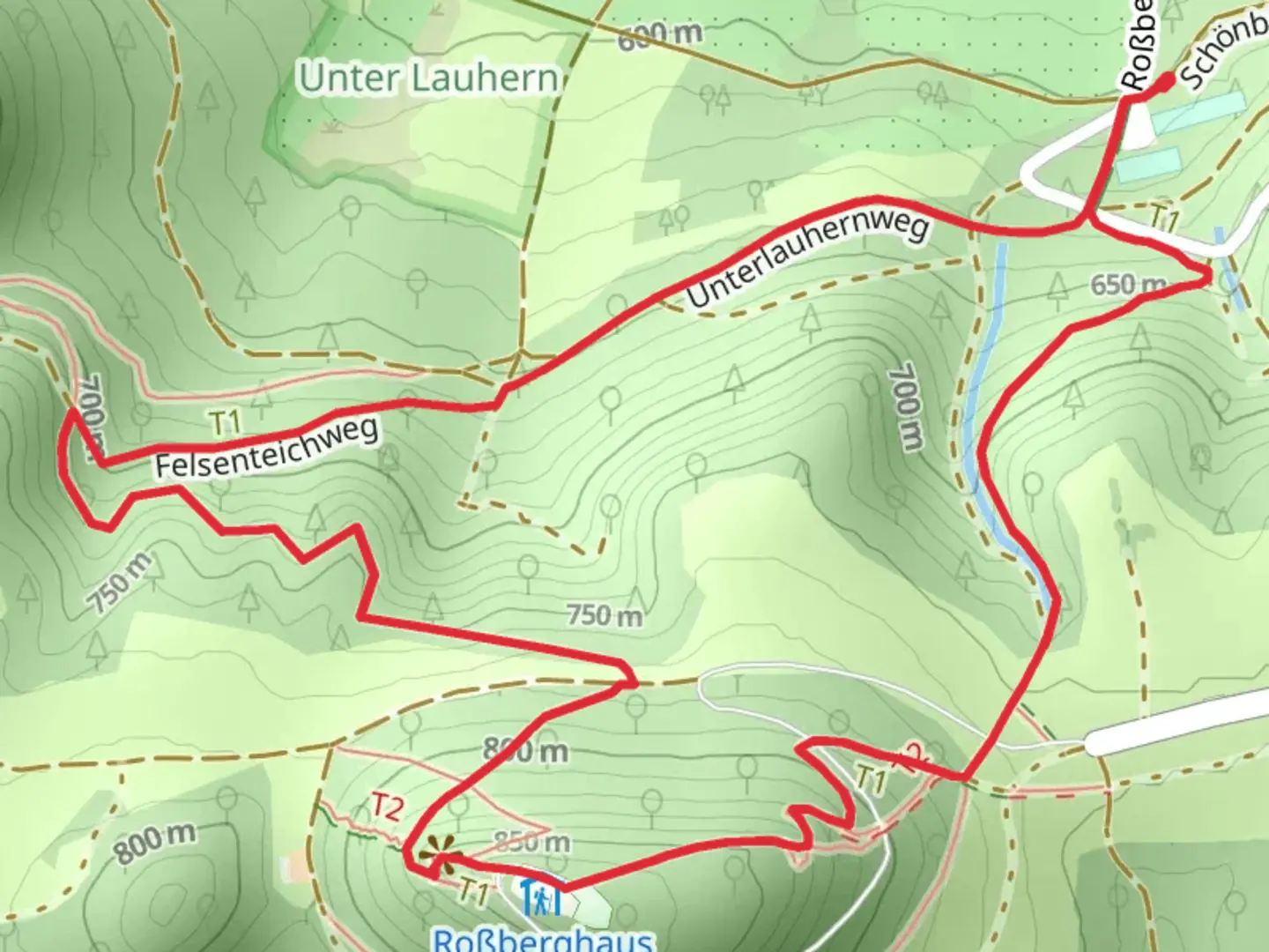
4.2 km
~1 hrs 20 min
297 m
Loop
“Experience natural beauty and historical intrigue on the rewarding 4 km Roßberg via Hochgehkaempft trail.”
Starting near Reutlingen, Germany, the Roßberg via Hochgehkaempft trail is a delightful loop that spans approximately 4 km (2.5 miles) with an elevation gain of around 200 meters (656 feet). This medium-difficulty trail offers a mix of natural beauty, historical significance, and a few challenges that make it a rewarding hike for those prepared to tackle it.
Getting There
To reach the trailhead, you can either drive or use public transport. If driving, head towards Reutlingen and follow signs to the Roßberg area. There is parking available near the trailhead. For those using public transport, take a train to Reutlingen Hauptbahnhof and then a local bus towards Gönningen. The nearest bus stop is Gönningen Rathaus, from where the trailhead is a short walk away.
Trail Navigation
For navigation, it is highly recommended to use the HiiKER app, which provides detailed maps and real-time updates to ensure you stay on the right path.
Trail Highlights
The trail begins with a gentle ascent through a mixed forest, where you can enjoy the shade and the sounds of local wildlife. After about 1 km (0.6 miles), you will reach a clearing that offers your first panoramic view of the Swabian Jura, a range of low mountains in Baden-Württemberg.
Historical Significance
As you continue, you will come across the remnants of ancient fortifications. These ruins date back to the Roman era, offering a glimpse into the region's rich history. The area was once a strategic point for the Romans, and you can still see some of the old stone walls and foundations.
Flora and Fauna
The trail is home to a variety of plant and animal species. In the spring and summer, the meadows are filled with wildflowers, including orchids and gentians. Keep an eye out for local wildlife such as deer, foxes, and a variety of bird species, including the rare red kite.
Roßberg Summit
At approximately 2 km (1.2 miles) into the hike, you will reach the Roßberg summit. The elevation gain here is around 150 meters (492 feet) from the trailhead. The summit offers a 360-degree view of the surrounding landscape, including the Swabian Jura and the distant Alps on a clear day. There is also a small shelter where you can take a break and enjoy a snack.
Descent and Return
The descent begins after the summit, taking you through a different section of the forest. This part of the trail is steeper and can be slippery after rain, so take care with your footing. After about 1 km (0.6 miles) of descent, you will re-enter the forest, where the trail levels out and leads you back to the starting point.
Practical Tips
- Wear sturdy hiking boots, especially for the steeper sections.
- Bring enough water and snacks, as there are no facilities along the trail.
- Check the weather forecast before you go, as the trail can be challenging in wet conditions.
- Use the HiiKER app for navigation to ensure you stay on track.
This trail offers a perfect blend of natural beauty, historical intrigue, and a moderate challenge, making it a must-visit for hikers in the Reutlingen area.

Comments and Reviews
User comments, reviews and discussions about the Roßberg via Hochgehkaempft, Germany.
4.0
average rating out of 5
2 rating(s)