Download
Preview
Add to list
More
14.9 km
~3 hrs 50 min
514 m
Point-to-Point
“Embark on a scenic 15 km hike from Engelskirchen to Osberghausen, blending history, wildlife, and panoramic views.”
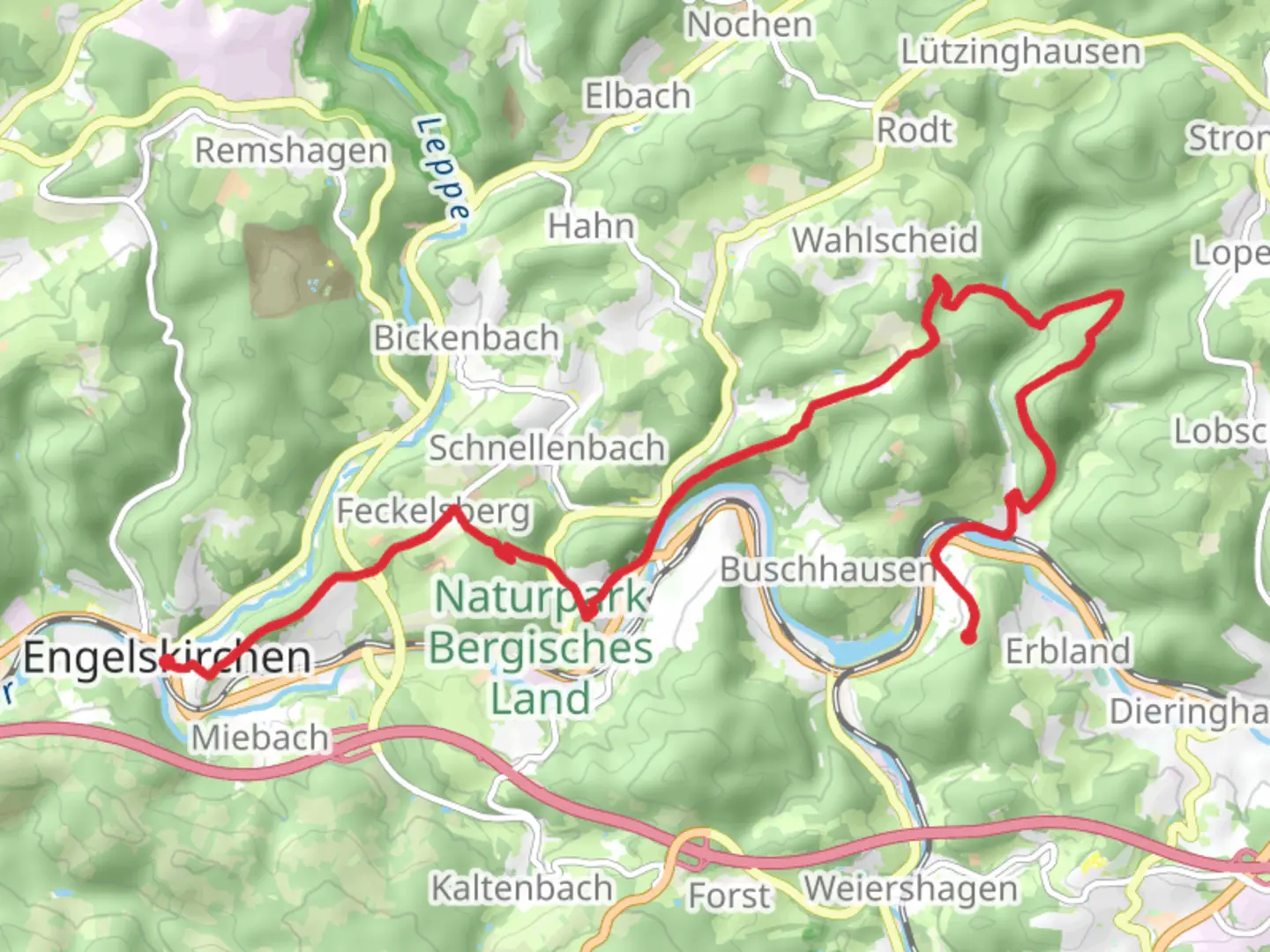
Starting near the picturesque town of Oberbergischer Kreis in Germany, this 15 km (approximately 9.3 miles) point-to-point trail offers a moderate challenge with an elevation gain of around 500 meters (about 1,640 feet). The trailhead is easily accessible by both public transport and car. If you're taking public transport, you can catch a train to Engelskirchen station, which is well-connected to major cities like Cologne. From there, it's a short walk to the trailhead. For those driving, there are parking facilities available near the starting point.### Trail OverviewThe trail begins in the charming town of Engelskirchen, known for its historical significance and beautiful architecture. As you set off, you'll be greeted by a mix of paved paths and forest trails. The initial section is relatively flat, allowing you to ease into the hike. After about 2 km (1.2 miles), you'll start to encounter a gradual incline as you make your way through dense woodlands.### Key Landmarks and Points of Interest#### EngelskirchenEngelskirchen is a town with a rich history dating back to the medieval period. As you walk through, you'll notice the St. Peter and Paul Church, a beautiful example of Gothic architecture. This area is also known for its traditional half-timbered houses, which add a quaint charm to the surroundings.#### Nature and WildlifeAs you ascend, the trail takes you through lush forests teeming with wildlife. Keep an eye out for deer, foxes, and a variety of bird species. The forest canopy provides ample shade, making this section particularly enjoyable during the warmer months. Around the 5 km (3.1 miles) mark, you'll come across a small clearing with a picturesque stream, an ideal spot for a short break.### Mid-Trail Highlights#### Panoramic ViewsAround the halfway point, approximately 7.5 km (4.7 miles) in, you'll reach one of the highest points of the trail. Here, you'll be rewarded with panoramic views of the surrounding valleys and hills. This vantage point is perfect for photography, so make sure to bring your camera.#### Historical SitesContinuing on, you'll pass by several historical landmarks, including old mills and remnants of ancient settlements. These sites offer a glimpse into the region's past and are often accompanied by informational plaques detailing their significance.### Final StretchAs you descend towards Osberghausen, the trail becomes less strenuous. The final 3 km (1.9 miles) are relatively flat, taking you through open meadows and along the banks of the Agger River. This section is particularly scenic, with wildflowers blooming in the spring and summer months.### Navigation and SafetyFor navigation, it's highly recommended to use the HiiKER app, which provides detailed maps and real-time updates. The trail is well-marked, but having a reliable navigation tool ensures you stay on track. Make sure to carry enough water and snacks, as there are limited facilities along the route. ### Reaching OsberghausenThe trail concludes in the small village of Osberghausen. From here, you can catch a train back to Engelskirchen or continue your journey to other nearby destinations. Osberghausen also offers a few local eateries where you can enjoy a well-deserved meal after your hike.

What to expect?
Activity types
Comments and Reviews
User comments, reviews and discussions about the Engelskirchen to Osberghausen Walk, Germany.
average rating out of 5
0 rating(s)