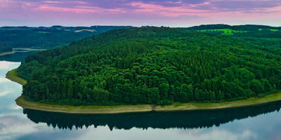
Börlinghausen to Ohl via Brucher Talsperre and Lingesetalsperre and Wupperweg
13.5 km
~3 hrs 3 min
215 m
“Explore lush landscapes and historical reservoirs on a moderately challenging hike near Oberbergischer Kreis.”
Starting your journey near Oberbergischer Kreis, Germany, this 14 km (approximately 8.7 miles) point-to-point trail offers a delightful mix of natural beauty and historical intrigue. With an elevation gain of around 200 meters (about 656 feet), the trail is rated as medium difficulty, making it suitable for moderately experienced hikers.
### Getting There
To reach the trailhead, you can drive to the vicinity of Oberbergischer Kreis, where parking is generally available. If you prefer public transport, the nearest significant town is Gummersbach, which is well-connected by train. From Gummersbach, local buses can take you closer to the starting point, though you may need to walk a short distance to reach the trailhead.
### Trail Highlights
#### Brucher Talsperre
As you set off, the first major landmark you'll encounter is the Brucher Talsperre, a picturesque reservoir surrounded by lush greenery. This area is perfect for a brief pause to enjoy the serene waters and perhaps spot some local bird species. The reservoir plays a crucial role in the region's water management and is a popular spot for both locals and visitors seeking tranquility.
#### Lingesetalsperre
Continuing along the trail, you'll come across the Lingesetalsperre, another stunning reservoir. This section of the hike offers gentle inclines and descents, providing a pleasant challenge without being overly strenuous. The Lingesetalsperre is known for its clear waters and the surrounding forest, which is home to a variety of wildlife, including deer and foxes. Keep your eyes peeled for these creatures, especially during the quieter parts of the day.
#### Historical Significance
The region around Oberbergischer Kreis has a rich history, with evidence of human settlement dating back to ancient times. The reservoirs themselves are part of a broader network of water management systems developed in the early 20th century, reflecting the area's industrial heritage. As you hike, consider the historical context of the landscape, shaped by both natural forces and human ingenuity.
### Navigation and Safety
For navigation, HiiKER is an excellent tool to ensure you stay on track. The trail is well-marked, but having a reliable navigation app can provide peace of mind, especially in areas where the path might be less distinct. Always check the weather forecast before setting out, as conditions can change rapidly, and ensure you have appropriate gear for the hike.
### Final Stretch to Ohl
As you approach the end of the trail near Ohl, the landscape opens up, offering expansive views of the surrounding countryside. This final stretch is a rewarding conclusion to your hike, with gentle slopes leading you to the endpoint. Whether you're hiking for the exercise, the scenery, or the history, this trail offers a rich tapestry of experiences that will linger in your memory long after you've finished.
Reviews
User comments, reviews and discussions about the Börlinghausen to Ohl via Brucher Talsperre and Lingesetalsperre and Wupperweg, Germany.
0.0
average rating out of 5
0 rating(s)


