Thaler Hoehe via Jakobsweg Tirol - Allgaeu and Oberallgaeuer Rundwanderweg
11.4 km
~3 hrs 7 min
501 m
“Embark on a scenic, challenging hike through Oberallgäu's lush landscapes and historic pilgrimage routes.”
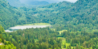
Starting your adventure near Oberallgäu, Germany, this challenging loop trail spans approximately 11 kilometers (about 6.8 miles) with an elevation gain of around 500 meters (approximately 1,640 feet). The trail is known for its demanding terrain, making it suitable for experienced hikers seeking a rewarding challenge.### Getting ThereTo reach the trailhead, you can drive to the vicinity of Oberallgäu, where parking is generally available. For those relying on public transport, the nearest major town is Sonthofen, which is well-connected by train. From Sonthofen, local buses can take you closer to the trailhead, with stops near the starting point of the hike.### Trail Highlights#### Scenic Views and Natural BeautyAs you embark on this loop, you'll be greeted by the stunning landscapes of the Allgäu Alps. The trail offers panoramic views of the surrounding peaks and valleys, especially as you ascend towards Thaler Höhe. The lush greenery and diverse flora along the path provide a picturesque backdrop, particularly vibrant during the spring and summer months.#### Historical SignificanceThe trail intersects with the Jakobsweg Tirol - Allgäu, a historic pilgrimage route that has been traveled for centuries. This path is part of the larger network of Camino de Santiago routes, which have significant cultural and religious importance. As you walk, consider the footsteps of countless pilgrims who have journeyed here before you, seeking spiritual solace and adventure.### Wildlife and FloraThe region is home to a variety of wildlife, including deer, foxes, and a wide array of bird species. Keep an eye out for the majestic golden eagle, often seen soaring above the alpine meadows. The trail's flora is equally impressive, with alpine flowers such as edelweiss and gentians adding splashes of color to the landscape.### Navigation and SafetyGiven the trail's difficulty, it's crucial to be well-prepared. The path can be steep and rocky in sections, requiring sturdy hiking boots and possibly trekking poles for added stability. Weather conditions can change rapidly in the mountains, so pack layers and rain gear. For navigation, the HiiKER app is an excellent tool to ensure you stay on track and can access detailed maps and trail information.### Points of InterestAs you loop back towards your starting point, take a moment to visit the nearby village of Immenstadt, known for its charming Bavarian architecture and local hospitality. The area offers a glimpse into the traditional lifestyle of the Allgäu region, with opportunities to sample local cuisine and explore quaint shops.This trail offers a blend of natural beauty, historical intrigue, and physical challenge, making it a memorable experience for those ready to tackle its demanding paths.
Reviews
User comments, reviews and discussions about the Thaler Hoehe via Jakobsweg Tirol - Allgaeu and Oberallgaeuer Rundwanderweg, Germany.
5.0
average rating out of 5
4 rating(s)
Loading reviews...


