Download
Preview
Add to list
More
10.7 km
~3 hrs 51 min
1040 m
Out and Back
“Embark on the Schnippenkopf Peak Walk for 11 kilometers of scenic beauty, history, and a rewarding summit.”
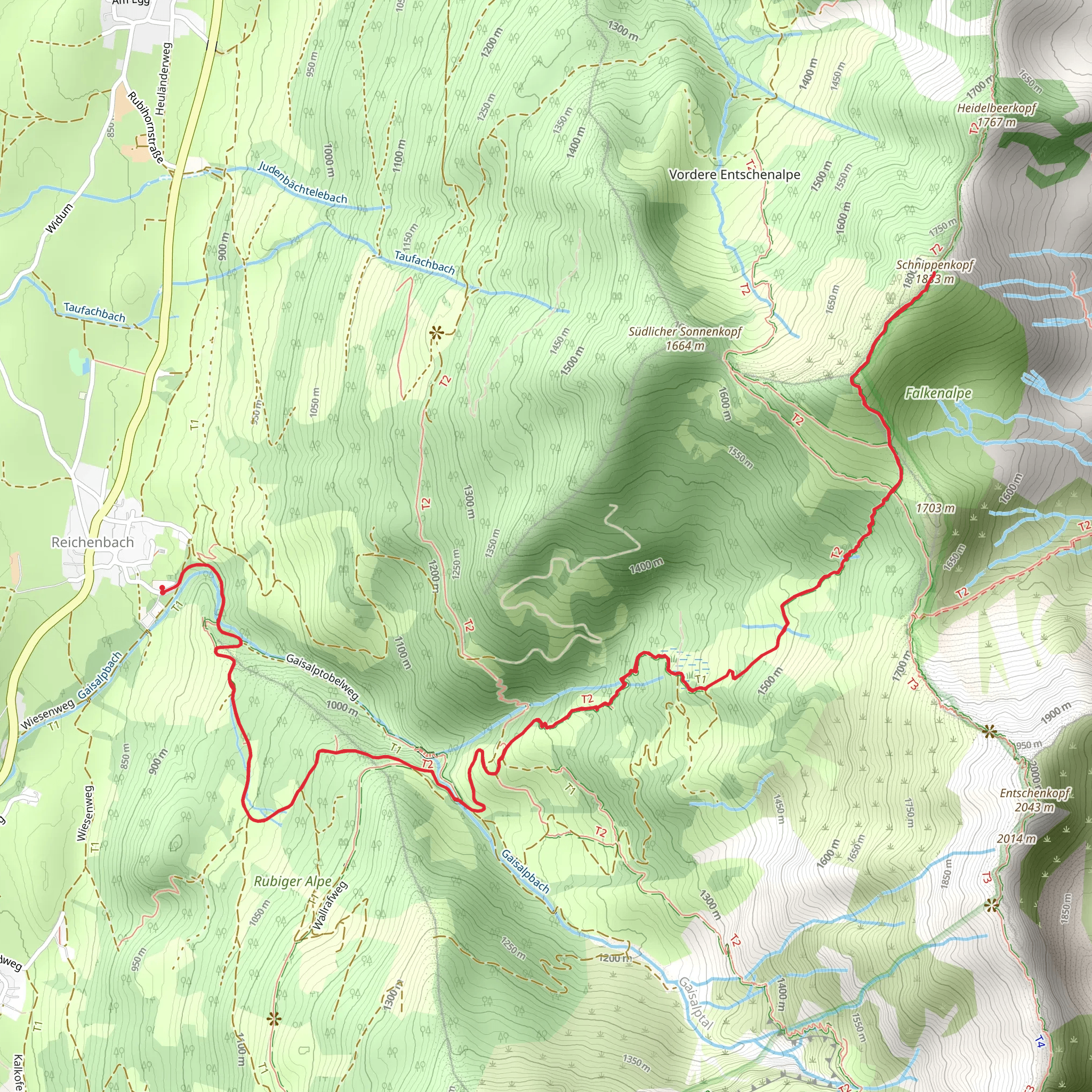
Starting your journey near Oberallgäu, Germany, the Schnippenkopf Peak Walk from Reichenbach is an invigorating out-and-back trail that spans approximately 11 kilometers (around 6.8 miles) with an elevation gain of about 1000 meters (3280 feet). This medium-difficulty hike offers a blend of natural beauty, historical significance, and a rewarding summit experience.### Getting There To reach the trailhead, you can either drive or use public transport. If driving, set your GPS to Reichenbach, Oberallgäu, Germany. For those opting for public transport, take a train to Sonthofen, the nearest major town, and then a local bus to Reichenbach. The trailhead is conveniently located near the village, making it easily accessible.### Trail Overview The hike begins in the picturesque village of Reichenbach, nestled in the Allgäu Alps. As you start your ascent, you'll traverse through lush meadows and dense forests, offering a serene and tranquil environment. The initial part of the trail is relatively gentle, allowing you to warm up before the steeper sections begin.### Key Landmarks and Elevation - First Kilometer (0-1 km / 0-0.6 miles): The trail starts with a gentle incline through verdant meadows. You'll gain about 100 meters (328 feet) in elevation, making it a pleasant start. - Second to Fourth Kilometer (1-4 km / 0.6-2.5 miles): As you continue, the trail becomes steeper and more challenging. You'll pass through dense forest areas, gaining another 300 meters (984 feet) in elevation. Keep an eye out for local wildlife such as deer and various bird species. - Fifth Kilometer (4-5 km / 2.5-3.1 miles): This section is the most strenuous, with a significant elevation gain of about 400 meters (1312 feet). The trail becomes rocky and may require careful navigation. Using HiiKER can be particularly helpful here to stay on track. - Summit (5.5 km / 3.4 miles): Reaching the Schnippenkopf Peak, you'll be rewarded with panoramic views of the Allgäu Alps and the surrounding valleys. The summit offers a perfect spot for a well-deserved break and some memorable photographs.### Historical Significance The region around Oberallgäu has a rich history dating back to medieval times. The Allgäu Alps were historically significant for their strategic location and natural resources. The area was once a bustling trade route, and remnants of old trade paths can still be seen along the trail. Additionally, the region played a role during World War II, with various bunkers and fortifications hidden in the forests.### Flora and Fauna The trail is a haven for nature enthusiasts. In spring and summer, the meadows are adorned with wildflowers such as alpine roses and gentians. The forests are home to a variety of wildlife, including deer, foxes, and numerous bird species. If you're lucky, you might even spot a golden eagle soaring above.### Safety and Preparation Given the elevation gain and the rocky sections, it's essential to wear sturdy hiking boots and carry trekking poles for added stability. Weather in the Alps can be unpredictable, so pack layers and a waterproof jacket. Ensure you have enough water and snacks, as there are no facilities along the trail. Using HiiKER for navigation will help you stay on the correct path and avoid any potential detours.### Return Journey The descent follows the same path back to Reichenbach. While descending, take your time to enjoy the views and the natural beauty that you might have missed on the way up. The return journey offers a different perspective and is generally easier on the legs.This hike is a perfect blend of physical challenge and natural beauty, making it a must-do for any hiking enthusiast visiting the Allgäu region.
What to expect?
Activity types
Comments and Reviews
User comments, reviews and discussions about the Schnippenkopf Peak Walk from Reichenbach, Germany.
4.6
average rating out of 5
5 rating(s)

