Download
Preview
Add to list
More
12.1 km
~3 hrs 11 min
463 m
Loop
“Discover the enchanting Buchenegger Wasserfälle Loop: a 12 km hike of stunning waterfalls, wildlife, and history.”
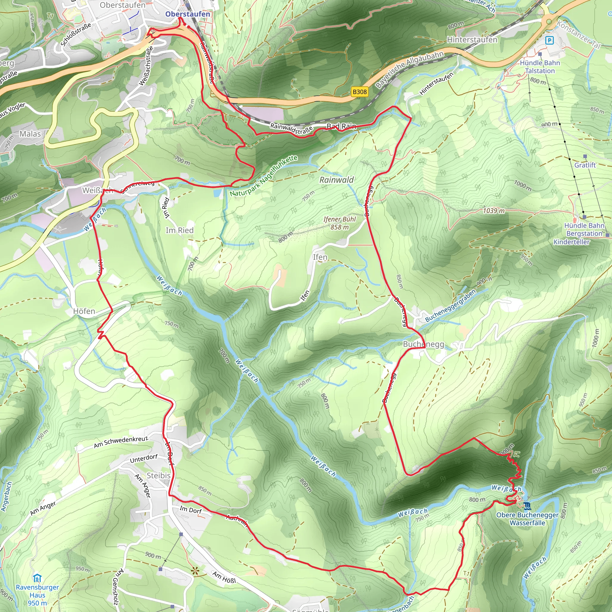
Starting your adventure near Oberallgäu, Germany, the Buchenegger Wasserfälle Loop via Wandergebiet Oberstaufen is a captivating 12 km (7.5 miles) loop trail with an elevation gain of approximately 400 meters (1,312 feet). This medium-difficulty trail offers a blend of natural beauty, historical significance, and a moderate challenge suitable for most hikers.
Getting There To reach the trailhead, you can either drive or use public transport. If driving, set your GPS to Oberallgäu, Germany, and look for parking near the Wandergebiet Oberstaufen area. For those using public transport, take a train to Oberstaufen station. From there, local buses or a short taxi ride will get you to the trailhead.
Trail Overview The trail begins with a gentle ascent through lush meadows and dense forests, offering a serene start to your hike. As you progress, the path becomes steeper, leading you to the first significant landmark, the Buchenegger Wasserfälle. These stunning waterfalls are a highlight of the trail, cascading down rocky cliffs into crystal-clear pools below. The sound of rushing water and the sight of the falls make this a perfect spot for a short break and some photography.
Flora and Fauna The trail is rich in biodiversity. Keep an eye out for native wildlife such as deer, foxes, and a variety of bird species. The flora is equally impressive, with dense forests of beech and spruce trees, interspersed with colorful wildflowers during the spring and summer months.
Historical Significance The region around Oberallgäu has a rich history dating back to medieval times. As you hike, you'll come across several old farmhouses and traditional Bavarian architecture, offering a glimpse into the area's past. The trail itself has been used for centuries, initially as a route for local farmers and traders.
Navigation For navigation, it's highly recommended to use HiiKER, which provides detailed maps and real-time updates. The trail is well-marked, but having a reliable navigation tool ensures you stay on track and can explore any interesting detours safely.
Key Landmarks - **Buchenegger Wasserfälle**: Located about 4 km (2.5 miles) into the hike, these waterfalls are the trail's main attraction. - **Hochgrat Mountain**: Visible from various points along the trail, this mountain offers stunning panoramic views of the Allgäu Alps. - **Traditional Bavarian Farmhouses**: Scattered along the trail, these structures provide a historical context and are perfect for photography.
Elevation Profile The trail's elevation gain is gradual but steady. Starting at around 800 meters (2,625 feet) above sea level, you'll ascend to approximately 1,200 meters (3,937 feet) at the highest point. The descent is equally gradual, making it easier on the knees and allowing you to enjoy the surrounding scenery.
Final Stretch The last few kilometers of the trail take you through open meadows and pastures, offering a relaxing end to your hike. You'll eventually loop back to the starting point near Wandergebiet Oberstaufen, where you can find local eateries and cafes to relax and refuel.
This trail offers a perfect blend of natural beauty, moderate physical challenge, and historical intrigue, making it a must-visit for any hiking enthusiast.
What to expect?
Activity types
Comments and Reviews
User comments, reviews and discussions about the Buchenegger Wasserfälle Loop via Wandergebiet Oberstaufen, Germany.
4.5
average rating out of 5
4 rating(s)

