7.2 km
~1 hrs 49 min
226 m
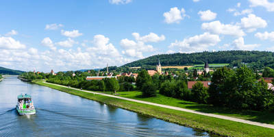
“Explore a captivating trail where lush nature, vibrant wildlife, and medieval history seamlessly converge.”
Nestled in the picturesque region near Neumarkt in der Oberpfalz, Germany, this 7 km (approximately 4.3 miles) loop trail offers a delightful blend of natural beauty and historical intrigue. With an elevation gain of around 200 meters (about 656 feet), the trail is rated as medium difficulty, making it accessible for most hikers with a moderate level of fitness.
### Getting There
To reach the trailhead, travelers can opt for public transport or drive. If you're using public transport, the nearest major town is Neumarkt in der Oberpfalz, which is well-connected by train. From Neumarkt, local buses or a short taxi ride can take you to the vicinity of the trailhead. For those driving, there are parking facilities available near the starting point, which is conveniently located close to the town.
### Trail Highlights
#### Natural Features
The trail meanders through a diverse landscape, showcasing the region's rich natural features. Hikers will traverse through dense forests, open meadows, and rocky outcrops. The area is known for its karst formations, and you'll encounter several dolines—natural sinkholes that add a unique geological aspect to the hike. These formations are not only fascinating to observe but also serve as a reminder of the powerful natural processes that have shaped the landscape over millennia.
#### Wildlife and Flora
As you hike, keep an eye out for the local wildlife. The forests are home to a variety of bird species, and if you're lucky, you might spot deer or foxes. The flora is equally captivating, with wildflowers dotting the meadows in spring and summer, providing bursts of color against the lush greenery.
### Historical Significance
The region around Neumarkt in der Oberpfalz has a rich history, and remnants of this past can be seen along the trail. The area was historically significant during the Middle Ages, serving as a strategic location due to its proximity to trade routes. While hiking, you may come across old stone walls and ruins that hint at the area's storied past. These historical landmarks offer a glimpse into the lives of those who once inhabited the region.
### Navigation and Safety
For navigation, it's recommended to use the HiiKER app, which provides detailed maps and real-time updates to ensure you stay on track. The trail is well-marked, but having a reliable navigation tool can enhance your hiking experience and provide peace of mind.
While the trail is generally safe, it's always wise to be prepared. Wear sturdy hiking boots, carry sufficient water, and check the weather forecast before setting out. The trail can be slippery after rain, so caution is advised in wet conditions.
Embarking on this trail promises a rewarding experience, offering a harmonious blend of nature, wildlife, and history. Whether you're a seasoned hiker or a curious explorer, the Doline and Wildensteiner Steig trail is sure to leave a lasting impression.
Reviews
User comments, reviews and discussions about the Doline and Wildensteiner Steig, Germany.
0.0
average rating out of 5
0 rating(s)


