11.7 km
~2 hrs 33 min
127 m
“Explore a scenic 12 km loop near Märkisch-Oderland, blending natural beauty, history, and diverse wildlife.”
Starting near Märkisch-Oderland, Germany, the Langer Haussee, Mittelsee, and Gamensee via Gruener Punkt trail is a scenic 12 km (7.5 miles) loop with an elevation gain of approximately 100 meters (328 feet). This medium-difficulty trail offers a delightful mix of natural beauty, historical significance, and serene landscapes.### Getting There
To reach the trailhead, you can either drive or use public transport. If driving, set your GPS to Märkisch-Oderland, Germany. For those using public transport, take a train to Strausberg Nord station, which is the nearest significant landmark. From there, you can catch a local bus or taxi to the trailhead.### Trail Overview
The trail begins near the picturesque Langer Haussee, a serene lake surrounded by lush greenery. As you start your hike, you'll be greeted by the calming sounds of nature and the sight of waterfowl gliding across the lake's surface. The first section of the trail is relatively flat, making it an excellent warm-up for the more challenging parts ahead.### Key Landmarks and Natural Features
- Langer Haussee (0-2 km / 0-1.2 miles): The trail skirts the edge of this beautiful lake, offering numerous spots for photography and bird-watching. Keep an eye out for swans, ducks, and other waterfowl.
- Mittelsee (2-5 km / 1.2-3.1 miles): As you continue, you'll reach Mittelsee, another tranquil lake. This section of the trail is slightly more elevated, providing panoramic views of the surrounding forest.
- Gamensee (5-8 km / 3.1-5 miles): The trail then leads you to Gamensee, a smaller but equally charming lake. This area is rich in flora and fauna, so take your time to appreciate the diverse plant life and perhaps spot a deer or two.### Historical Significance
The region around Märkisch-Oderland has a rich history dating back to medieval times. As you hike, you'll come across remnants of old settlements and possibly even ancient stone markers. These historical artifacts offer a glimpse into the lives of the people who once inhabited this area.### Navigation and Safety
Given the trail's moderate difficulty, it's advisable to use a reliable navigation tool like HiiKER to stay on track. The trail is well-marked, but having a digital map can be incredibly useful, especially in the denser forest sections.### Final Stretch
The last part of the trail loops back towards Langer Haussee, gradually descending and offering a gentle cooldown. This section is less strenuous, allowing you to reflect on the journey and enjoy the final views of the lake.### Wildlife and Flora
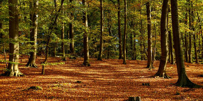
Throughout the hike, you'll encounter a variety of wildlife, including birds, deer, and small mammals. The flora is equally diverse, with a mix of deciduous and coniferous trees, wildflowers, and shrubs. Spring and autumn are particularly beautiful times to hike this trail, as the changing seasons bring vibrant colors and a fresh atmosphere.### Practical Tips
- Footwear: Wear sturdy hiking boots, as some sections can be muddy, especially after rain.
- Water and Snacks: Carry enough water and snacks to keep your energy levels up.
- Weather: Check the weather forecast before you go, as conditions can change rapidly.
- Leave No Trace: Be mindful of the environment and carry out all your trash.This trail offers a perfect blend of natural beauty, historical intrigue, and moderate physical challenge, making it a rewarding experience for any hiker.
Reviews
User comments, reviews and discussions about the Langer Haussee, Mittelsee and Gamensee via Gruener Punkt, Germany.
4.0
average rating out of 5
3 rating(s)
Loading reviews...


