Download
Preview
Add to list
More
11.7 km
~3 hrs 6 min
468 m
Loop
“The Rund Um Lorsbach trail blends natural beauty, historical landmarks, and diverse wildlife in a rewarding 12 km hike.”
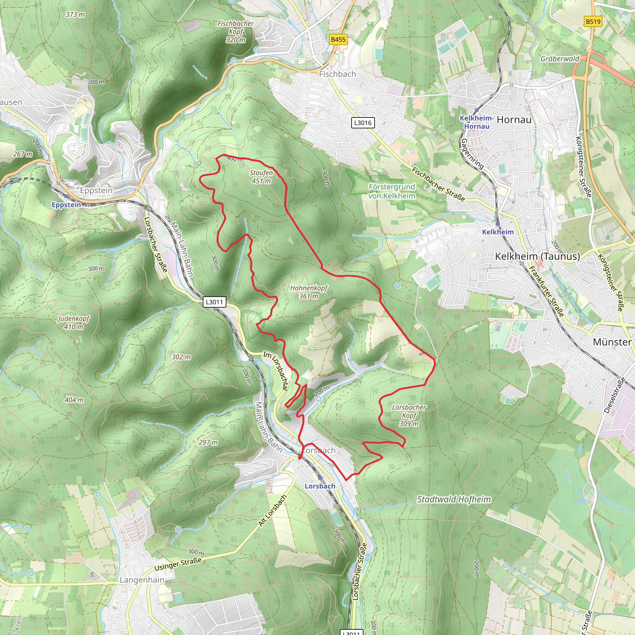
Starting near Main-Taunus-Kreis, Germany, the Rund Um Lorsbach trail is a scenic 12 km (approximately 7.5 miles) loop with an elevation gain of around 400 meters (about 1,312 feet). This medium-difficulty trail offers a blend of natural beauty, historical landmarks, and diverse wildlife, making it a rewarding experience for hikers.
Getting There To reach the trailhead, you can either drive or use public transport. If you're driving, set your GPS to Lorsbach, a district in Hofheim am Taunus. There are parking facilities available near the starting point. For those using public transport, take a train to Hofheim am Taunus station and then a local bus to Lorsbach. The trailhead is conveniently located near the town center, making it easily accessible.
Trail Overview The trail begins with a gentle ascent through mixed forests, offering a cool and shaded environment. As you progress, you'll encounter a variety of tree species, including oak, beech, and pine. The first significant landmark is the Lorsbach Castle ruins, located about 3 km (1.9 miles) into the hike. These ruins date back to the medieval period and offer a glimpse into the region's historical past.
Flora and Fauna The trail is rich in biodiversity. Keep an eye out for local wildlife such as deer, foxes, and a variety of bird species. In spring and summer, the forest floor is carpeted with wildflowers, including bluebells and anemones. The diverse plant life provides ample opportunities for nature photography.
Mid-Trail Highlights Around the 6 km (3.7 miles) mark, you'll reach a scenic viewpoint that offers panoramic views of the Taunus Mountains and the Rhine-Main region. This is an excellent spot for a break and some photography. The elevation gain to this point is approximately 200 meters (656 feet), making it a moderate climb.
Historical Significance The region around Lorsbach has a rich history dating back to Roman times. Evidence of Roman roads and settlements can still be found in the area. The trail itself passes by several historical markers that provide information about the region's past, including its role in medieval trade routes.
Navigation and Safety The trail is well-marked, but it's always a good idea to have a reliable navigation tool. HiiKER is recommended for its detailed maps and real-time updates. The terrain can be uneven in places, so sturdy hiking boots are advisable. During the wetter months, some sections may be muddy, so be prepared for varying trail conditions.
Final Stretch The last 3 km (1.9 miles) of the trail take you through open meadows and farmland, offering a different landscape compared to the forested sections. This part of the hike is relatively flat, allowing for a leisurely finish. You'll eventually loop back to the starting point near Lorsbach, completing your 12 km journey.
This trail offers a well-rounded hiking experience with its mix of natural beauty, historical landmarks, and diverse wildlife. Whether you're a seasoned hiker or a casual walker, the Rund Um Lorsbach trail provides a fulfilling outdoor adventure.
What to expect?
Activity types
Comments and Reviews
User comments, reviews and discussions about the Rund Um Lorsbach, Germany.
4.71
average rating out of 5
7 rating(s)

