Download
Preview
Add to list
More
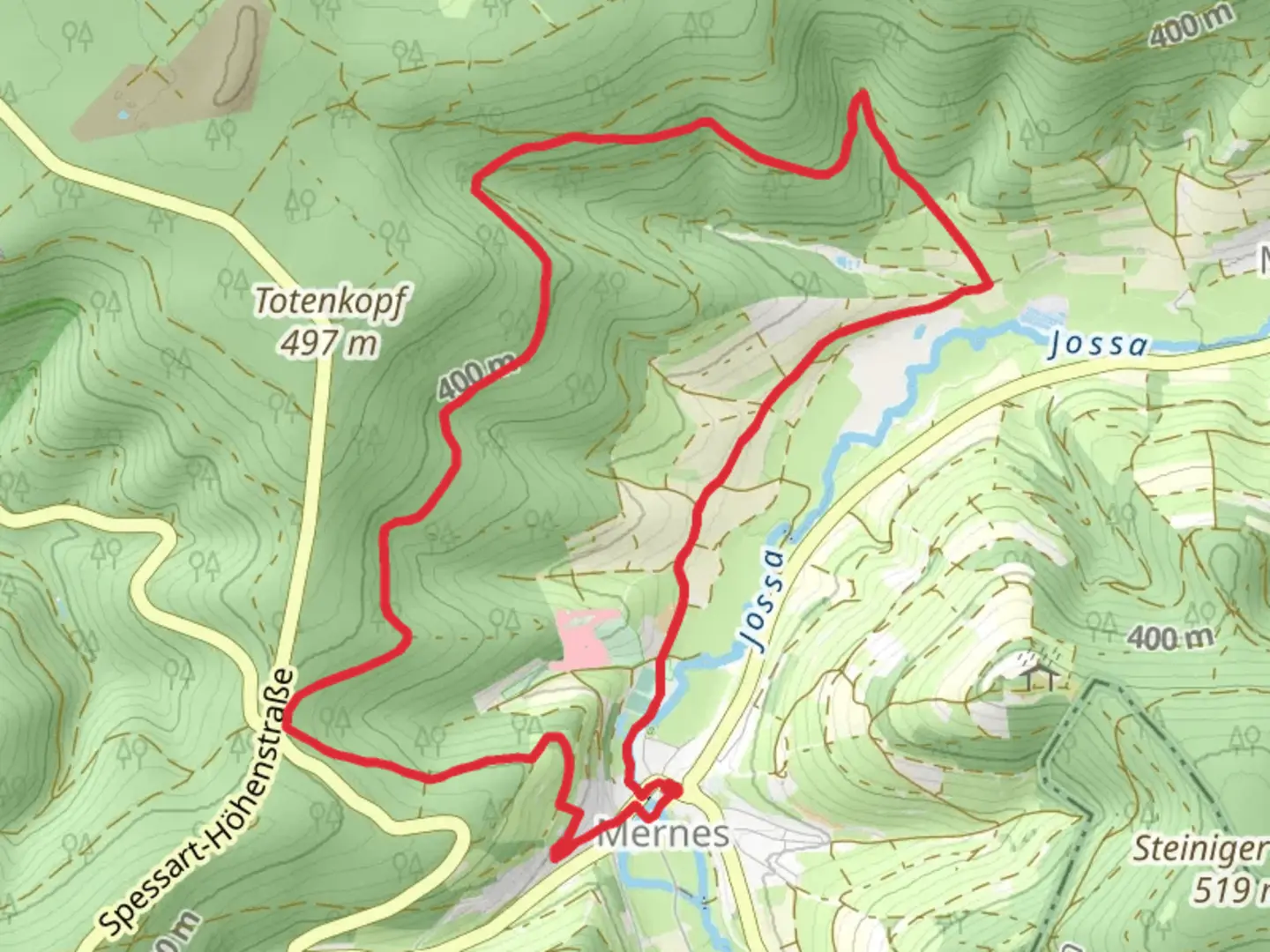
10.9 km
~2 hrs 38 min
278 m
Loop
“The Mernes-Wanderweg Ahorn trail offers a scenic 11 km loop through forests, meadows, and historic sites.”
Starting near Main-Kinzig-Kreis, Germany, the Mernes-Wanderweg Ahorn is a delightful 11 km (approximately 6.8 miles) loop trail with an elevation gain of around 200 meters (656 feet). This trail is rated as medium difficulty, making it suitable for moderately experienced hikers.### Getting There To reach the trailhead, you can drive or use public transport. If driving, set your GPS to Mernes, a small village in the Main-Kinzig-Kreis district. For those using public transport, take a train to the nearest major station, Bad Soden-Salmünster, and then a local bus to Mernes. The trailhead is conveniently located near the village center, making it easily accessible.### Trail Overview The Mernes-Wanderweg Ahorn offers a mix of forested paths, open meadows, and scenic viewpoints. Starting from the village, the trail quickly ascends into the Spessart hills, providing a moderate challenge right from the beginning. The initial climb is about 100 meters (328 feet) over the first 2 km (1.2 miles), offering a good warm-up for the rest of the hike.### Key Landmarks and Points of Interest - Ahorn Tree: One of the trail's highlights is the ancient Ahorn (maple) tree, located about 3 km (1.8 miles) into the hike. This tree is not only a natural wonder but also a historical marker, believed to be over 300 years old. - Spessart Forest: As you continue, you'll enter the dense Spessart forest, known for its rich biodiversity. Keep an eye out for local wildlife such as deer, foxes, and a variety of bird species. - Panoramic Viewpoint: Around the 6 km (3.7 miles) mark, the trail opens up to a panoramic viewpoint. Here, you can take a break and enjoy sweeping views of the Kinzig Valley and the surrounding hills. This spot is perfect for a picnic or a quick rest. - Historical Sites: The region has a rich history, and you'll pass by several old stone markers and remnants of ancient settlements. These sites offer a glimpse into the area's past, dating back to medieval times.### Navigation and Safety The trail is well-marked with signs and blazes, but it's always a good idea to have a reliable navigation tool. The HiiKER app is highly recommended for this trail, providing detailed maps and real-time GPS tracking to ensure you stay on course.### Flora and Fauna The trail is a haven for nature enthusiasts. In spring and summer, the meadows are adorned with wildflowers, while the forested sections offer a cool respite with their lush canopy. Autumn brings a spectacular display of colors as the leaves change, making it a popular time for hiking.### Final Stretch The last 3 km (1.8 miles) of the trail descend gradually back towards Mernes. This section is relatively easy, allowing you to enjoy the final leg of your hike without much strain. As you approach the village, you'll pass through more open fields and small patches of woodland, offering a gentle and scenic end to your journey.### Practical Tips - Footwear: Sturdy hiking boots are recommended due to the varied terrain. - Weather: Check the weather forecast before heading out, as the trail can be slippery after rain. - Supplies: Carry enough water and snacks, as there are no facilities along the trail. - Wildlife: Be respectful of the local wildlife and maintain a safe distance.This trail offers a perfect blend of natural beauty, historical intrigue, and moderate physical challenge, making it a rewarding experience for those who venture onto it.

Comments and Reviews
User comments, reviews and discussions about the Mernes-Wanderweg Ahorn, Germany.
4.0
average rating out of 5
1 rating(s)