Strimberg via Haard - Stimberg route and Katenkreuz Rundweg
Download
Preview
Add to list
More
11.2 km
~2 hrs 29 min
150 m
Loop
“Explore the Strimberg via Haard - Stimberg trail for a scenic 11 km journey through history and nature.”
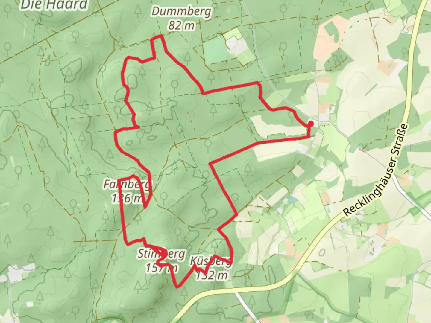
Starting near Kreis Recklinghausen, Germany, the Strimberg via Haard - Stimberg route and Katenkreuz Rundweg is a captivating loop trail that spans approximately 11 km (6.8 miles) with an elevation gain of around 100 meters (328 feet). This trail is rated as medium difficulty, making it accessible for moderately experienced hikers.
Getting There
To reach the trailhead, you can drive or use public transport. If driving, set your GPS to the nearest known address: Haardstraße, 45739 Oer-Erkenschwick, Germany. For those using public transport, take a train to Recklinghausen Hauptbahnhof and then a bus to Oer-Erkenschwick, where you can walk to the trailhead.
Trail Overview
The trail begins with a gentle ascent through the Haard forest, a serene area known for its dense woodlands and diverse flora. As you hike, you'll encounter a variety of tree species, including oak, beech, and pine, providing ample shade and a cool environment even during warmer months.
Significant Landmarks
At approximately 3 km (1.86 miles) into the hike, you'll reach the Stimberg, the highest point in the Haard forest. The elevation here is modest but offers a rewarding view of the surrounding landscape. This area is also home to several historical markers, including remnants of old mining operations that date back to the early 20th century. These markers provide a glimpse into the region's industrial past, which played a significant role in shaping the local communities.
Wildlife and Nature
As you continue along the trail, keep an eye out for local wildlife. The Haard forest is home to a variety of animals, including deer, foxes, and numerous bird species. Birdwatchers will particularly enjoy spotting woodpeckers, owls, and various songbirds. The underbrush is rich with ferns and wildflowers, adding vibrant colors to the forest floor.
Navigation and Waypoints
Navigating this trail is straightforward, but it's always wise to have a reliable navigation tool. The HiiKER app is highly recommended for this purpose, as it provides detailed maps and real-time updates. Key waypoints to look out for include the Katenkreuz, a historical cross located around the 7 km (4.35 miles) mark. This cross has stood for centuries and is a popular spot for a brief rest and photo opportunity.
Final Stretch
The final stretch of the trail loops back towards the starting point, descending gently through more open terrain. This section offers a different perspective of the Haard forest, with more open spaces and meadows. It's a great area to spot butterflies and other insects, especially during the spring and summer months.
Practical Tips
- Wear sturdy hiking boots, as some sections of the trail can be uneven.
- Bring plenty of water and snacks, as there are limited facilities along the route.
- Check the weather forecast before heading out, as the trail can become muddy after rain.
This trail offers a perfect blend of natural beauty, historical significance, and moderate physical challenge, making it an excellent choice for a day hike in the Kreis Recklinghausen area.

Comments and Reviews
User comments, reviews and discussions about the Strimberg via Haard - Stimberg route and Katenkreuz Rundweg, Germany.
4.4
average rating out of 5
5 rating(s)