8.3 km
~1 hrs 58 min
187 m
“Embark on an 8 km loop through Hardehausen's diverse landscapes, rich history, and majestic wildlife.”
Starting near Kreis Höxter, Germany, the Wisentweg West and KlimaErlebnis Route - Hardehausen is an 8 km (approximately 5 miles) loop trail with an elevation gain of around 100 meters (328 feet). This trail offers a medium difficulty rating, making it suitable for moderately experienced hikers.
### Getting There To reach the trailhead, you can drive or use public transport. If driving, set your GPS to Hardehausen, a small village in the Kreis Höxter district. For those using public transport, take a train to Warburg station, which is the nearest major station. From Warburg, you can catch a local bus to Hardehausen. The trailhead is conveniently located near the village, making it easily accessible.
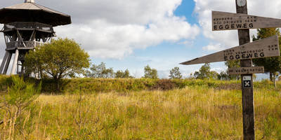
### Trail Overview The trail begins near the village of Hardehausen, a region rich in history and natural beauty. As you start your hike, you'll notice the well-marked paths that guide you through a diverse landscape. The initial section of the trail is relatively flat, allowing you to ease into the hike.
### Significant Landmarks and Nature One of the first significant landmarks you'll encounter is the Wisentgehege Hardehausen, a bison enclosure that is home to the European bison, also known as Wisent. This enclosure is part of a conservation effort to protect and reintroduce this majestic animal into the wild. The sight of these magnificent creatures grazing in their natural habitat is a highlight of the trail.
As you continue, the trail takes you through dense forests and open meadows, offering a variety of flora and fauna. Keep an eye out for deer, foxes, and a plethora of bird species that inhabit the area. The forested sections provide ample shade, making it a pleasant hike even during warmer months.
### Elevation and Terrain The trail features a gradual elevation gain of around 100 meters (328 feet), with some sections being steeper than others. The most challenging part of the hike is a moderate ascent about halfway through the loop. This section rewards you with panoramic views of the surrounding countryside, making the effort well worth it.
### Historical Significance Hardehausen itself has a rich history, dating back to the 12th century when it was home to a Cistercian monastery. The remnants of the monastery can still be seen today and are worth a short detour. The monastery played a significant role in the region's development, influencing both the cultural and natural landscape.
### Navigation and Safety For navigation, it is highly recommended to use the HiiKER app, which provides detailed maps and real-time updates. The trail is well-marked, but having a reliable navigation tool ensures you stay on track and can explore additional points of interest.
### Final Stretch The final stretch of the trail loops back towards Hardehausen, passing through more open fields and small streams. This section is relatively flat, allowing you to cool down and enjoy the serene environment. As you approach the end of the loop, you'll find several picnic spots where you can rest and take in the beautiful scenery.
This 8 km loop offers a perfect blend of natural beauty, wildlife, and historical significance, making it a rewarding hike for those looking to explore the rich landscapes of Kreis Höxter.
Reviews
User comments, reviews and discussions about the Wisentweg West and KlimaErlebnis Route - Hardehausen, Germany.
0.0
average rating out of 5
0 rating(s)


