Download
Preview
Add to list
More
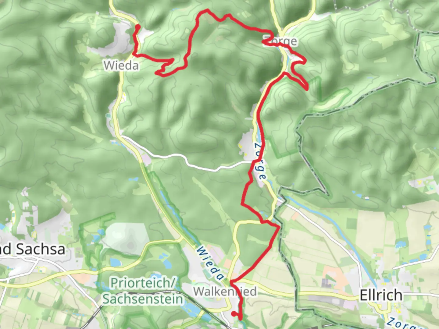
16.9 km
~4 hrs 11 min
492 m
Point-to-Point
“Embark on a mesmerizing hike through lush forests and historic sites in Germany's enchanting Harz Mountains.”
Nestled in the picturesque Harz Mountains of Germany, the trail from Wieda to Walkenried offers a delightful journey through lush forests, serene landscapes, and historical sites. This point-to-point trail spans approximately 17 kilometers (about 10.5 miles) with an elevation gain of around 400 meters (approximately 1,312 feet), making it a moderately challenging hike suitable for those with some hiking experience.### Getting ThereThe trailhead is conveniently located near Göttingen, Germany. If you're traveling by car, you can reach Wieda by taking the A38 and B243 roads, which provide a scenic drive through the region. For those relying on public transport, trains and buses connect Göttingen to nearby towns, with the closest station being in Bad Sachsa. From there, local buses or a short taxi ride will bring you to Wieda, where your adventure begins.### Trail Highlights#### Forested Pathways and Scenic ViewsAs you set out from Wieda, you'll be immediately enveloped by the dense, enchanting forests that characterize this region. The trail meanders through a mix of deciduous and coniferous trees, offering a rich tapestry of greens in the warmer months and a stunning array of colors in autumn. Keep an eye out for local wildlife, including deer and a variety of bird species, which are often spotted along the trail.#### Historical SignificanceOne of the most intriguing aspects of this hike is its proximity to the historical Walkenried Abbey, a former Cistercian monastery founded in the 12th century. As you approach Walkenried, approximately 15 kilometers (9.3 miles) into your hike, you'll have the opportunity to explore the abbey's ruins and learn about its significant role in the region's medieval history. The abbey is a testament to the architectural prowess of the time and offers a glimpse into the monastic life that once thrived here.### Navigational TipsThe trail is well-marked, but it's always wise to have a reliable navigation tool at hand. HiiKER is an excellent resource for ensuring you stay on track and can provide real-time updates on your progress. The app can also alert you to any changes in trail conditions or weather, which can be particularly useful in the unpredictable climate of the Harz Mountains.### Final Stretch to WalkenriedAs you near the end of your hike, the trail descends gently towards Walkenried, offering panoramic views of the surrounding countryside. This section of the trail is particularly rewarding, with open fields and the distant silhouette of the abbey creating a picturesque backdrop. Upon reaching Walkenried, you'll find several options for refreshments and relaxation, allowing you to unwind after your journey.This hike from Wieda to Walkenried is not only a physical challenge but also a journey through the natural beauty and rich history of the Harz region. Whether you're drawn by the allure of the forest, the call of the wild, or the whispers of history, this trail promises an unforgettable experience.

Comments and Reviews
User comments, reviews and discussions about the Wieda to Walkenried Walk, Germany.
average rating out of 5
0 rating(s)