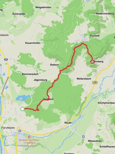
15.6 km
~3 hrs 27 min
203 m
“Embark on a serene hike through lush meadows and historic landscapes in charming Franconian countryside.”
Starting your journey near the charming town of Forchheim, Germany, this 16 km (approximately 10 miles) point-to-point trail offers a delightful and easy hiking experience with an elevation gain of around 200 meters (about 656 feet). The trail is perfect for those looking to enjoy a leisurely day in nature, with gentle ascents and descents that make it accessible for hikers of all levels.### Getting ThereForchheim is well-connected by public transport, making it easy to reach the trailhead. If you're traveling by train, Forchheim has a railway station with regular services from major cities like Nuremberg and Bamberg. From the station, local buses or a short taxi ride can take you to the trailhead. If you prefer to drive, Forchheim is conveniently located near the A73 motorway, with ample parking options available in the town.### Trail HighlightsAs you set off from Forchheim, the trail meanders through the picturesque Franconian countryside, offering a blend of natural beauty and cultural heritage. The initial section of the trail takes you through lush meadows and fields, where you might spot local wildlife such as deer and various bird species. Keep your eyes peeled for the vibrant wildflowers that dot the landscape, especially during the spring and summer months.### Historical SignificanceThe region around Forchheim is steeped in history, with roots dating back to the early Middle Ages. As you hike, you'll pass through areas that have been inhabited for centuries, offering a glimpse into the past. Forchheim itself is known for its well-preserved medieval architecture, including the impressive Kaiserpfalz, a former imperial palace that now serves as a museum. While the trail itself doesn't pass directly by these landmarks, they are worth exploring if you have time before or after your hike.### Navigating the TrailThe trail is well-marked, but it's always a good idea to have a reliable navigation tool on hand. The HiiKER app is an excellent resource for this trail, providing detailed maps and real-time updates to ensure you stay on course. As you continue your hike, you'll traverse gentle hills and wooded areas, offering a peaceful retreat from the hustle and bustle of everyday life.### Approaching Untere MarkAs you near the end of your journey, the trail descends gently towards Untere Mark. This quaint village is a perfect spot to relax and reflect on your hike. Take some time to explore the local area, perhaps enjoying a meal at a traditional Franconian restaurant or visiting nearby attractions.This trail from Forchheim to Untere Mark is a delightful way to experience the natural beauty and rich history of the Franconian region. Whether you're a seasoned hiker or a casual walker, this easy trail offers something for everyone.

Reviews
User comments, reviews and discussions about the Forchheim to Untere Mark Walk, Germany.
0.0
average rating out of 5
0 rating(s)
Loading reviews...