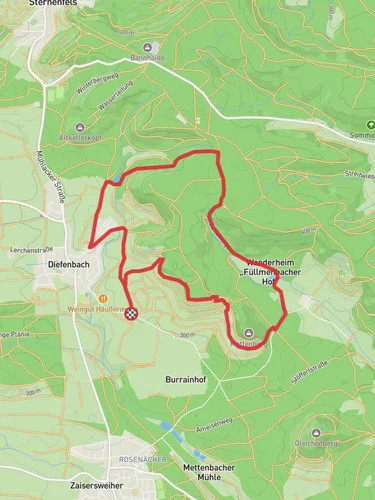
10.3 km
~2 hrs 15 min
124 m
“Explore history and nature on the scenic, moderately challenging 10 km Reutsee and Burrainhof Loop trail.”
Starting near Enzkreis, Germany, the Reutsee and Burrainhof Loop is a delightful 10 km (6.2 miles) trail with an elevation gain of approximately 100 meters (328 feet). This loop trail is rated as medium difficulty, making it suitable for moderately experienced hikers.### Getting There
To reach the trailhead, you can either drive or use public transport. If driving, set your GPS to Enzkreis, Germany, and look for parking near the Reutsee area. For those using public transport, take a train or bus to the nearest station in Enzkreis and then a local bus or taxi to the trailhead.### Trail Overview
The trail begins near the serene Reutsee, a small but picturesque lake that offers a tranquil start to your hike. As you set off, you'll be greeted by lush greenery and the gentle sounds of nature. The initial part of the trail is relatively flat, making it a good warm-up for the more varied terrain ahead.### Key Landmarks and Sections#### Reutsee
At approximately 1 km (0.6 miles) into the hike, you'll reach the shores of Reutsee. This is a great spot to take a short break, enjoy the view, and perhaps even spot some local wildlife such as ducks and swans. The lake is surrounded by dense forest, providing a peaceful atmosphere.#### Burrainhof
Continuing on, you'll head towards Burrainhof, a historical farmstead that dates back several centuries. Around the 5 km (3.1 miles) mark, you'll arrive at Burrainhof, where you can explore the old farm buildings and learn about the agricultural history of the region. This area is also a good spot for a picnic, with several benches and open spaces available.### Flora and Fauna
The trail is rich in biodiversity. As you hike, you'll pass through mixed forests of oak, beech, and pine. In the spring and summer months, the forest floor is carpeted with wildflowers, including bluebells and daisies. Keep an eye out for local wildlife such as deer, foxes, and a variety of bird species.### Elevation and Terrain
The trail features a gentle elevation gain of around 100 meters (328 feet), spread out over the 10 km (6.2 miles). The terrain is varied, with sections of forest paths, open meadows, and some rocky areas. Good hiking boots are recommended to navigate the different surfaces comfortably.### Navigation
For navigation, it's advisable to use the HiiKER app, which provides detailed maps and real-time updates. The trail is well-marked, but having a reliable navigation tool will ensure you stay on track and can fully enjoy the hike without any worries.### Historical Significance
The region around Enzkreis has a rich history, with settlements dating back to the Roman era. Burrainhof itself is a testament to the area's agricultural heritage, offering a glimpse into the rural life of past centuries. The trail also passes by several old stone markers and boundary stones, adding a historical dimension to your hike.### Final Stretch
As you loop back towards the starting point, the trail takes you through more open landscapes, offering panoramic views of the surrounding countryside. This final section is relatively easy, allowing you to cool down and reflect on the diverse experiences of the hike.Whether you're interested in history, nature, or simply looking for a peaceful day out, the Reutsee and Burrainhof Loop offers a well-rounded hiking experience.
Reviews
User comments, reviews and discussions about the Reutsee and Burrainhof Loop, Germany.
4.0
average rating out of 5
4 rating(s)
Loading reviews...


