Download
Preview
Add to list
More
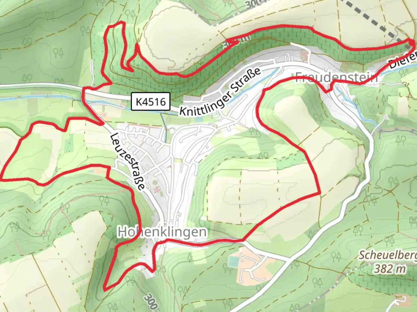
9.7 km
~2 hrs 28 min
321 m
Loop
“Explore enchanting history and nature on the Maulbronner Steige and Hohenklingen trail's scenic journey.”
Nestled in the picturesque landscapes of Enzkreis, Germany, the Maulbronner Steige and Hohenklingen trail offers a captivating journey through history and nature. This loop trail spans approximately 10 kilometers (about 6.2 miles) with an elevation gain of around 300 meters (approximately 984 feet), making it a moderately challenging adventure for hikers.
Getting There
To reach the trailhead, you can drive to Enzkreis, where parking is available near the starting point. For those relying on public transport, the nearest major hub is the city of Pforzheim. From there, you can take a regional train or bus to Maulbronn, a town renowned for its UNESCO World Heritage Site, the Maulbronn Monastery. The trailhead is conveniently located near this historic landmark, providing an excellent starting point for your hike.
Trail Highlights
Historical Significance
The Maulbronner Steige and Hohenklingen trail is steeped in history, with the Maulbronn Monastery being a focal point. Founded in the 12th century, this Cistercian abbey is one of the best-preserved medieval monastic complexes in Europe. As you embark on the trail, take a moment to explore the monastery's stunning architecture and serene surroundings.
Scenic Landscapes
The trail meanders through a diverse landscape, offering a mix of dense forests, open meadows, and gentle hills. As you ascend, you'll be rewarded with panoramic views of the surrounding countryside, characterized by rolling hills and lush greenery. The elevation gain is gradual, making it accessible for hikers with a moderate level of fitness.
Flora and Fauna
Nature enthusiasts will appreciate the rich biodiversity along the trail. The forests are home to a variety of tree species, including oak, beech, and pine. Keep an eye out for local wildlife, such as deer, foxes, and a variety of bird species. The changing seasons bring a vibrant display of colors, from the fresh greens of spring to the golden hues of autumn.
Navigation and Safety
To ensure a smooth hiking experience, it's advisable to use HiiKER for navigation. The trail is well-marked, but having a reliable map can help you stay on track and explore any additional paths or points of interest. As with any hike, it's important to wear appropriate footwear, carry sufficient water, and be prepared for changing weather conditions.
Points of Interest
As you progress along the trail, you'll encounter several noteworthy landmarks. The Hohenklingen Castle, perched atop a hill, offers a glimpse into the region's medieval past. Although the castle is now in ruins, it provides a fascinating backdrop and a perfect spot for a rest and a picnic.
The Maulbronner Steige and Hohenklingen trail is a delightful blend of history, nature, and scenic beauty, making it a must-visit for hikers exploring the Enzkreis region. Whether you're drawn by the historical allure of the Maulbronn Monastery or the tranquil charm of the surrounding landscapes, this trail promises an enriching and memorable experience.

Comments and Reviews
User comments, reviews and discussions about the Maulbronner Steige and Hohenklingen, Germany.
average rating out of 5
0 rating(s)