Download
Preview
Add to list
More
8.5 km
~2 hrs 10 min
294 m
Point-to-Point
“Explore Bielefeld's natural beauty and history on this 8 km moderate trail from Wetterhaeuschen to Wanderparkplatz.”
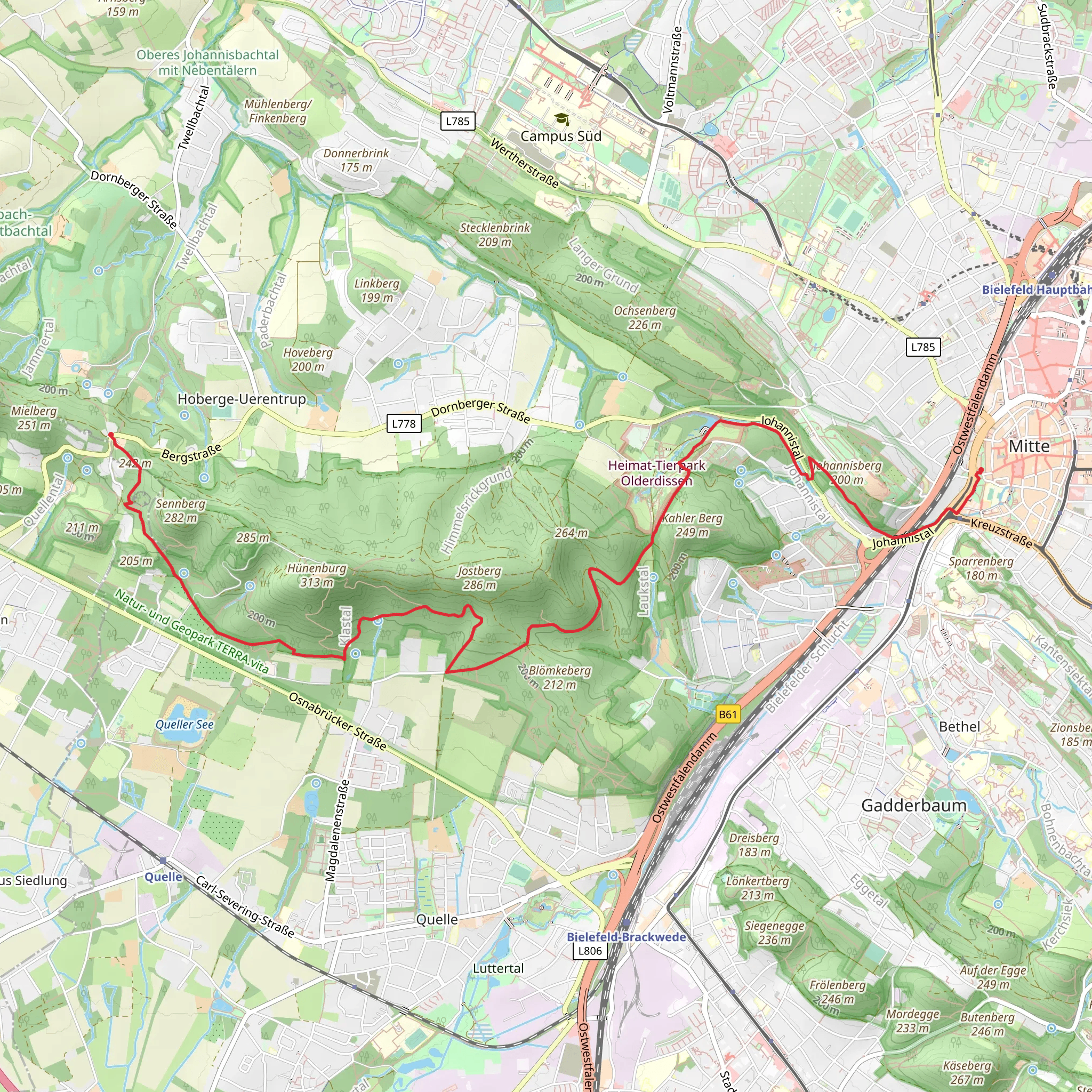
Starting near Bielefeld, Germany, this 8 km (approximately 5 miles) point-to-point trail offers a delightful mix of natural beauty and moderate challenge, making it an excellent choice for hikers looking to explore the region. The trail begins at Wetterhaeuschen and ends at Wanderparkplatz, passing through notable landmarks such as Stauweiher and Tierpark along the way.
Getting There To reach the trailhead near Bielefeld, you can either drive or use public transport. If driving, head towards the Wetterhaeuschen area, where you can find parking options nearby. For those using public transport, Bielefeld is well-connected by train and bus services. From the Bielefeld Hauptbahnhof (main train station), you can take a local bus to the Wetterhaeuschen area. Check local schedules for the most convenient routes.
Trail Overview The trail spans approximately 8 km (5 miles) with an elevation gain of around 200 meters (656 feet). This moderate difficulty rating makes it suitable for hikers with some experience, though beginners in good physical condition can also enjoy the hike.
Key Landmarks and Sections
#### Wetterhaeuschen to Stauweiher Starting at Wetterhaeuschen, the trail initially takes you through a serene forested area. The path is well-marked and relatively flat for the first 2 km (1.2 miles), making it a gentle introduction to the hike. As you approach Stauweiher, a picturesque reservoir, the trail begins to ascend gradually. This section offers beautiful views of the water and surrounding greenery, making it a perfect spot for a short break or photo opportunity.
#### Stauweiher to Tierpark Continuing from Stauweiher, the trail becomes more challenging as you gain elevation. Over the next 3 km (1.9 miles), you'll climb approximately 150 meters (492 feet). The path winds through dense forest, offering occasional glimpses of wildlife such as deer and various bird species. Keep an eye out for informative signs about the local flora and fauna. As you near Tierpark, the forest opens up, and you may encounter more hikers and families visiting the nearby animal park.
#### Tierpark to Wanderparkplatz The final stretch from Tierpark to Wanderparkplatz is about 3 km (1.9 miles) and features a mix of gentle descents and flat sections. This part of the trail is less strenuous, allowing you to enjoy the scenery without much effort. The path is well-maintained and easy to follow, leading you through open meadows and small wooded areas. As you approach Wanderparkplatz, you'll notice more signs of civilization, including picnic areas and rest spots.
Historical Significance The region around Bielefeld has a rich history dating back to medieval times. The nearby Sparrenburg Castle, although not directly on the trail, is a significant historical landmark worth visiting if you have extra time. The castle dates back to the 13th century and offers panoramic views of the surrounding area.
Navigation and Safety For navigation, it's highly recommended to use the HiiKER app, which provides detailed maps and real-time updates. Ensure you have adequate water, snacks, and appropriate footwear, as some sections can be slippery, especially after rain. Always check the weather forecast before heading out and inform someone of your plans.
This trail offers a balanced mix of natural beauty, moderate physical challenge, and opportunities to learn about the local ecosystem and history, making it a rewarding experience for any hiker.
Comments and Reviews
User comments, reviews and discussions about the Wetterhaeuschen to Wanderparkplatz via Stauweiher and Tierpark, Germany.
average rating out of 5
0 rating(s)

