Download
Preview
Add to list
More
9.2 km
~2 hrs 21 min
317 m
Loop
“Explore Franconian Switzerland's scenic beauty and history on this 9 km moderately challenging loop trail.”
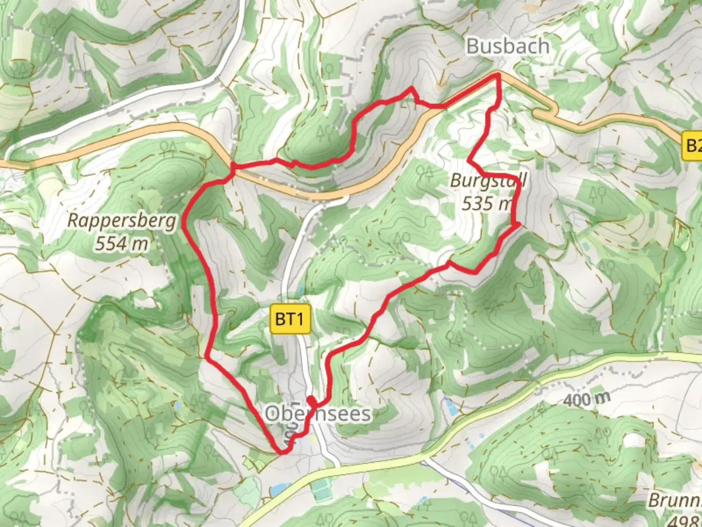
Starting near Bayreuth, Germany, the Obernsee Rundwanderweg and Oberailsfeld Hollfeld trail offers a delightful 9 km (5.6 miles) loop with an elevation gain of approximately 300 meters (984 feet). This medium-difficulty trail is perfect for those looking to explore the scenic beauty and historical richness of the Franconian Switzerland region.### Getting There To reach the trailhead, you can drive or use public transport. If driving, head towards the village of Obernsees, located about 20 km (12.4 miles) northeast of Bayreuth. There is ample parking available near the starting point. For those using public transport, take a train to Bayreuth and then a bus towards Obernsees. The nearest bus stop is Obernsees Therme, which is just a short walk from the trailhead.### Trail Overview The trail begins near the Obernsees Therme, a popular thermal bath, making it a convenient spot to start and end your hike. As you set off, you'll be greeted by lush forests and rolling hills, characteristic of the Franconian Switzerland region. The first section of the trail is relatively gentle, allowing you to ease into the hike.### Significant Landmarks Around the 2 km (1.2 miles) mark, you'll come across the ruins of the medieval castle, Burgstall Oberailsfeld. This site offers a glimpse into the region's historical past and provides a great spot for a short break and some photos. Continuing on, the trail takes you through dense woodlands and open meadows, offering a mix of shaded and sunny sections.### Nature and Wildlife The trail is rich in biodiversity. Keep an eye out for native wildlife such as deer, foxes, and a variety of bird species. The flora is equally impressive, with wildflowers dotting the meadows and ancient trees providing a canopy in the forested sections.### Elevation and Terrain As you progress, the trail begins to ascend more steeply, particularly around the 5 km (3.1 miles) mark. This section offers some of the most rewarding views, with panoramic vistas of the surrounding countryside. The elevation gain here is about 150 meters (492 feet) over a short distance, so be prepared for a bit of a workout.### Navigation The trail is well-marked, but it's always a good idea to have a reliable navigation tool. HiiKER is an excellent app for this purpose, providing detailed maps and real-time tracking to ensure you stay on course.### Historical Significance The region is steeped in history, with numerous small villages and ancient structures dotting the landscape. The trail itself passes through areas that have been inhabited for centuries, offering a unique blend of natural beauty and historical intrigue.### Final Stretch As you near the end of the loop, the trail descends gently back towards Obernsees. This final section is a great opportunity to cool down and reflect on the diverse landscapes and historical sites you've encountered. The trail concludes back at the Obernsees Therme, where you can relax and unwind in the thermal baths if you wish.This 9 km loop offers a perfect blend of natural beauty, historical landmarks, and moderate physical challenge, making it a must-do for any hiking enthusiast visiting the Bayreuth area.

What to expect?
Activity types
Comments and Reviews
User comments, reviews and discussions about the Obernsee Rundwanderweg and Oberailsfeld Hollfeld, Germany.
4.33
average rating out of 5
3 rating(s)