Download
Preview
Add to list
More
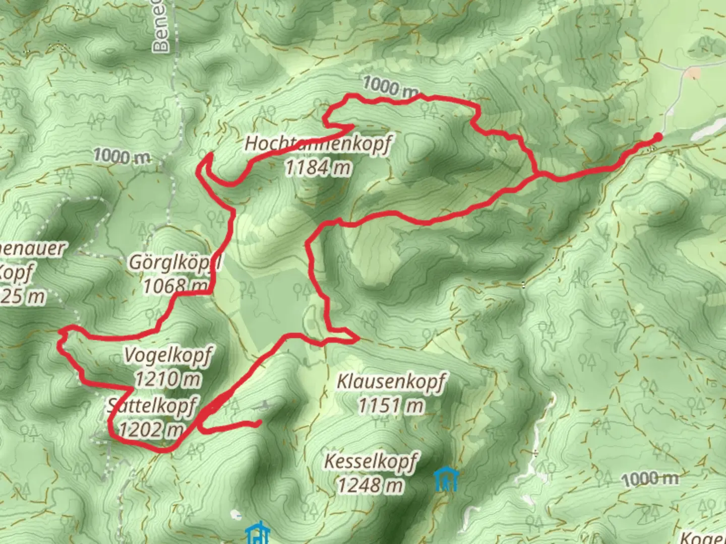
16.1 km
~4 hrs 41 min
881 m
Loop
“Embark on a mesmerizing journey through Bavarian alpine beauty, rich history, and diverse wildlife.”
Nestled in the picturesque Bavarian Alps, the Waxenstein and Hochtannenkopf Loop offers a captivating journey through lush forests, rugged peaks, and serene alpine meadows. This 16 km (approximately 10 miles) loop trail, with an elevation gain of around 800 meters (about 2,625 feet), is a moderately challenging adventure that begins near Bad Tölz-Wolfratshausen, Germany. ### Getting ThereTo reach the trailhead, travelers can opt for public transport or drive. If using public transport, take a train to Bad Tölz station, which is well-connected to Munich. From there, local buses or a short taxi ride will bring you to the trailhead. For those driving, the trailhead is accessible via the A95 motorway, with parking available nearby.### Trail HighlightsForests and Flora: The initial section of the trail meanders through dense forests, where hikers can enjoy the shade of towering spruce and fir trees. In spring and summer, the forest floor is adorned with a vibrant array of wildflowers, including the delicate Alpine aster and the striking gentian.Waxenstein Peak: As you ascend, the trail offers breathtaking views of the Waxenstein peak. This section is a steady climb, with the path becoming more rugged and rocky. The summit provides panoramic vistas of the surrounding alpine landscape, a perfect spot for a well-deserved break.Hochtannenkopf Ridge: Continuing along the loop, the trail leads to the Hochtannenkopf ridge. This area is known for its diverse wildlife, including chamois and marmots. Keep an eye out for these creatures, especially in the early morning or late afternoon.### Historical SignificanceThe region around Bad Tölz-Wolfratshausen has a rich history, with evidence of human settlement dating back to the Bronze Age. The trail itself traverses areas that were once significant trade routes in medieval times, connecting Bavaria with the Tyrolean regions. Hikers may encounter remnants of old stone paths and markers that hint at this historical past.### Navigation and SafetyGiven the moderate difficulty of the trail, it's advisable to use a reliable navigation tool like HiiKER to ensure you stay on course. The trail is well-marked, but weather conditions can change rapidly in the mountains, so be prepared with appropriate gear. Always check the weather forecast before setting out and carry sufficient water and snacks.### Final StretchThe descent back to the trailhead offers a gentle walk through open meadows, where you can enjoy the peaceful sounds of nature and perhaps spot a few grazing deer. As you complete the loop, the trail brings you back to the starting point, leaving you with a sense of accomplishment and a deeper appreciation for the natural beauty and historical richness of the Bavarian Alps.

Comments and Reviews
User comments, reviews and discussions about the Waxenstein and Hochtannenkopf Loop, Germany.
average rating out of 5
0 rating(s)