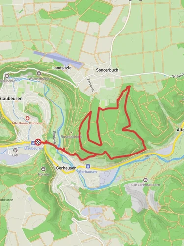
Schillerstein, Geißenklosterle and Bruckfels Loop via Eiszeit Jägerpfad
7.1 km
~2 hrs 11 min
453 m
“Discover history, nature, and panoramic views on this 7 km loop trail near Alb-Donau-Kreis, Germany.”
Starting near Alb-Donau-Kreis, Germany, this 7 km (4.3 miles) loop trail offers a moderate challenge with an elevation gain of approximately 400 meters (1,312 feet). The trailhead is accessible by car, with parking available nearby. For those using public transport, the nearest significant landmark is the town of Blaubeuren, which is well-connected by regional trains and buses.
### Trail Overview
The trail begins with a gentle ascent through a dense forest, where you'll be surrounded by a variety of native trees, including beech and oak. As you climb, keep an eye out for local wildlife such as deer and various bird species. The first significant landmark you'll encounter is the Schillerstein, a large rock formation named after the famous German poet Friedrich Schiller. This spot offers a great vantage point for panoramic views of the surrounding landscape.
### Geißenklosterle
Continuing along the trail, you'll reach Geißenklosterle, an archaeological site of great historical significance. This cave was inhabited by Ice Age hunters around 40,000 years ago, making it one of the oldest known human settlements in Europe. Informational plaques provide insights into the lives of these early inhabitants, and the site is a fascinating stop for history enthusiasts.
### Bruckfels
The trail then leads you to Bruckfels, another impressive rock formation. This area is particularly popular among rock climbers, so you might see some in action. The path here can be a bit steep and rocky, so make sure to wear sturdy hiking boots. The elevation gain in this section is around 150 meters (492 feet) over a distance of 1.5 km (0.9 miles).
### Eiszeit Jägerpfad
As you loop back towards the starting point, you'll follow the Eiszeit Jägerpfad, or Ice Age Hunter's Path. This part of the trail is relatively flat and takes you through a picturesque valley. The lush meadows and clear streams make it a perfect spot for a picnic. The trail is well-marked, but it's always a good idea to have a navigation tool like HiiKER to ensure you stay on track.
### Flora and Fauna
Throughout the hike, you'll encounter a diverse range of flora and fauna. In spring and summer, the meadows are filled with wildflowers, attracting butterflies and bees. The forested areas provide a habitat for various mammals, including foxes and badgers. Birdwatchers will also find plenty to observe, from woodpeckers to songbirds.
### Practical Information
The entire loop takes about 3 to 4 hours to complete, depending on your pace and how long you spend at each landmark. There are no facilities along the trail, so be sure to bring enough water and snacks. The trail is best hiked from late spring to early autumn when the weather is most favorable.
Whether you're a history buff, a nature lover, or just looking for a moderate hike with beautiful scenery, this trail offers something for everyone.
Reviews
User comments, reviews and discussions about the Schillerstein, Geißenklosterle and Bruckfels Loop via Eiszeit Jägerpfad, Germany.
0.0
average rating out of 5
0 rating(s)


