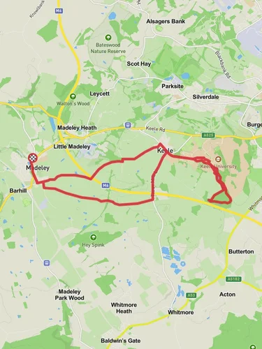
16.1 km
~3 hrs 28 min
158 m
“Explore charming villages, serene woodlands, and historical landmarks on the picturesque 16 km Madeley to Betley Loop.”
Starting near Staffordshire, England, the Madeley to Betley Loop is a picturesque 16 km (approximately 10 miles) trail with an elevation gain of around 100 meters (328 feet). This loop trail is rated as medium difficulty, making it suitable for moderately experienced hikers.
### Getting There To reach the trailhead, you can drive or use public transport. If driving, you can park near the village of Madeley, which is easily accessible via the A525 road. For those using public transport, the nearest train station is in Crewe, about 8 km (5 miles) away. From Crewe, you can take a local bus or taxi to Madeley.
### Trail Overview The trail begins in the charming village of Madeley, known for its historical buildings and serene countryside. As you set off, you'll pass through rolling farmlands and quaint English countryside, offering a peaceful start to your hike.
### Key Landmarks and Sections
#### Madeley Village At the beginning of your hike, take some time to explore Madeley. The village is home to several historical landmarks, including the Madeley Old Hall, a 16th-century manor house. The village church, All Saints, dates back to the 12th century and is worth a visit for its beautiful architecture and serene churchyard.
#### Farmlands and Woodlands About 3 km (1.8 miles) into the hike, you'll enter a series of farmlands and woodlands. This section is relatively flat and offers a mix of open fields and shaded paths. Keep an eye out for local wildlife such as deer, foxes, and a variety of bird species. The woodlands are particularly beautiful in the spring when bluebells carpet the forest floor.
#### Betley Village Around the halfway point, approximately 8 km (5 miles) into the hike, you'll reach the village of Betley. This picturesque village is known for its well-preserved Georgian and Victorian architecture. Betley Mere, a small lake, is a great spot for a short break. The village also has a few local pubs where you can enjoy a traditional English meal.
#### Return to Madeley The return leg of the loop takes you through more farmlands and gentle hills. This section offers stunning views of the Staffordshire countryside, especially as you gain a bit of elevation. The final stretch brings you back into Madeley, completing the loop.
### Navigation and Safety For navigation, it's highly recommended to use the HiiKER app, which provides detailed maps and real-time GPS tracking. The trail is well-marked, but having a reliable navigation tool will ensure you stay on track.
### Historical Significance The region around Madeley and Betley is steeped in history. Madeley Old Hall has connections to the English Civil War, and the area has been inhabited since Roman times. Betley, with its Georgian and Victorian heritage, offers a glimpse into England's architectural past.
### Wildlife and Nature The trail offers a rich tapestry of natural beauty. In addition to the bluebells in the woodlands, you might spot various bird species such as woodpeckers, owls, and kestrels. The farmlands are home to grazing sheep and cattle, adding to the pastoral charm of the hike.
### Final Stretch As you approach the end of the loop, the trail gently descends back into Madeley. This final section is a great opportunity to reflect on the diverse landscapes and historical landmarks you've encountered along the way.
This 16 km loop offers a balanced mix of natural beauty, historical landmarks, and moderate physical challenge, making it a rewarding experience for any hiker.
Reviews
User comments, reviews and discussions about the Madeley to Betley Loop, England.
0.0
average rating out of 5
0 rating(s)


