Download
Preview
Add to list
More
26.3 km
~1 day 0 hrs
162 m
Point-to-Point
“The Longton to Grimsargh Walk offers 26 km of scenic countryside, historical landmarks, and moderate hiking challenges.”
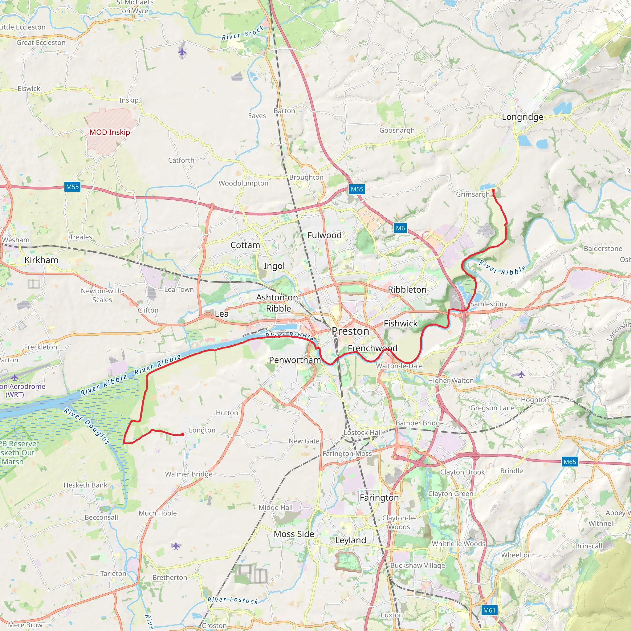
Starting near Lancashire, England, the Longton to Grimsargh Walk spans approximately 26 kilometers (16 miles) with an elevation gain of around 100 meters (328 feet). This point-to-point trail is estimated to be of medium difficulty, making it suitable for moderately experienced hikers.### Getting There To reach the trailhead, you can either drive or use public transport. If driving, you can park near Longton, a village in Lancashire. For those using public transport, the nearest significant landmark is Preston Railway Station. From there, you can take a local bus or taxi to Longton.### Trail Overview The trail begins in the charming village of Longton, known for its picturesque countryside and traditional English architecture. As you set off, you'll traverse through a mix of rural landscapes, including open fields, woodlands, and small villages.### Key Landmarks and Sections#### Longton to Hutton The first section of the trail takes you from Longton to Hutton, covering approximately 5 kilometers (3 miles). This part of the walk is relatively flat and easy, passing through agricultural lands and offering views of traditional English farmhouses. Keep an eye out for local wildlife such as rabbits and various bird species.#### Hutton to Penwortham Continuing from Hutton, the trail leads you towards Penwortham, another 6 kilometers (3.7 miles) away. This section includes a gentle ascent, gaining about 30 meters (98 feet) in elevation. Penwortham is known for its historical significance, with landmarks such as St. Mary's Church, which dates back to the 11th century.#### Penwortham to Preston The next leg of the journey takes you into the bustling town of Preston, approximately 4 kilometers (2.5 miles) from Penwortham. As you approach Preston, the landscape becomes more urban. Preston is rich in history, with notable sites like the Harris Museum and Art Gallery. This is a good spot to take a break and explore the town.#### Preston to Grimsargh The final stretch from Preston to Grimsargh is about 11 kilometers (6.8 miles). This section is a mix of urban and rural settings, gradually transitioning back to countryside as you near Grimsargh. The elevation gain here is minimal, making it a relatively easy walk to finish your journey. Grimsargh is a quaint village with a peaceful atmosphere, perfect for winding down after a long hike.### Navigation and Safety For navigation, it's highly recommended to use HiiKER, which provides detailed maps and real-time updates. The trail is generally well-marked, but having a reliable navigation tool will ensure you stay on track.### Flora and Fauna Throughout the hike, you'll encounter a variety of flora and fauna. The woodlands are home to oak, ash, and beech trees, while the open fields often feature wildflowers like bluebells and daisies. Wildlife enthusiasts might spot deer, foxes, and a variety of bird species, including kestrels and woodpeckers.### Historical Significance The region is steeped in history, from ancient churches to historical landmarks in Preston. The trail itself follows paths that have been used for centuries, offering a glimpse into England's rich past.This hike offers a blend of natural beauty, historical landmarks, and a moderate challenge, making it a rewarding experience for those who undertake it.
What to expect?
Activity types
Comments and Reviews
User comments, reviews and discussions about the Longton to Grimsargh Walk, England.
4.33
average rating out of 5
3 rating(s)

