Download
Preview
Add to list
More
18.7 km
~1 day 1 hrs
1675 m
Point-to-Point
“Explore 19 kilometers of stunning landscapes and rich history on the Helvellyn Walk from Thirlmere.”
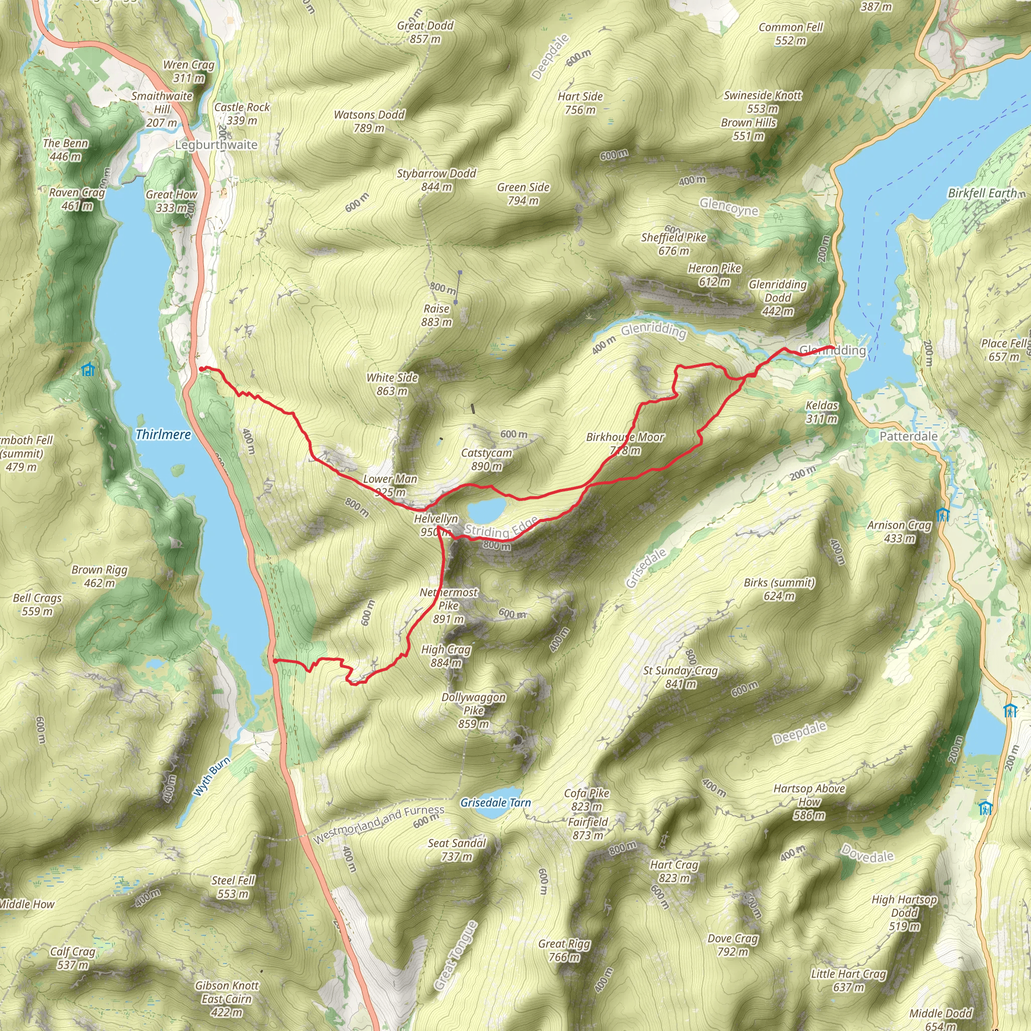
Starting near Cumberland, England, the Red Tarn, Birkhouse Moor, and Helvellyn Walk - Thirlmere is a point-to-point trail stretching approximately 19 kilometers (around 12 miles) with an elevation gain of about 1600 meters (5250 feet). This medium-difficulty hike offers a blend of stunning landscapes, historical landmarks, and diverse wildlife.
Getting There To reach the trailhead, you can drive or use public transport. If driving, head towards the Thirlmere Reservoir area, where parking is available. For those using public transport, the nearest significant landmark is the town of Keswick. From Keswick, you can take a local bus service to Thirlmere, which is well-connected and offers a convenient drop-off point near the trailhead.
Trail Overview The trail begins near Thirlmere, a reservoir that supplies water to Manchester. As you start your ascent, you'll be greeted by lush greenery and the serene waters of Thirlmere. The initial part of the trail is relatively gentle, allowing you to ease into the hike.
Red Tarn At approximately 5 kilometers (3 miles) into the hike, you'll reach Red Tarn, a small glacial lake nestled between the peaks. This is a great spot to take a break and enjoy the tranquil surroundings. The tarn is home to various aquatic plants and occasionally, you might spot red deer grazing nearby.
Birkhouse Moor Continuing from Red Tarn, the trail ascends towards Birkhouse Moor. This section is steeper, with an elevation gain of about 300 meters (985 feet) over 2 kilometers (1.2 miles). The moor offers panoramic views of the surrounding fells and valleys. Keep an eye out for peregrine falcons, which are known to nest in this area.
Helvellyn Summit The final push to Helvellyn's summit is the most challenging part of the hike. Over the next 4 kilometers (2.5 miles), you'll gain approximately 600 meters (1970 feet) in elevation. The path can be rocky and uneven, so sturdy hiking boots are essential. Helvellyn, standing at 950 meters (3117 feet), is the third-highest peak in England. The summit offers breathtaking views of the Lake District, including Ullswater and Striding Edge.
Historical Significance Helvellyn has a rich history, with its name derived from Old Welsh, meaning "pale yellow moorland." The area has been a popular hiking destination since the 18th century, attracting notable figures such as the poet William Wordsworth. The summit also features a memorial to Charles Gough, a painter who tragically died while attempting to cross Striding Edge in 1805.
Descent to Thirlmere The descent back to Thirlmere is less strenuous but requires careful navigation. Using HiiKER can help you stay on track. The path winds through grassy slopes and rocky outcrops, eventually leading you back to the reservoir. This section is about 8 kilometers (5 miles) with a gradual decline in elevation.
Wildlife and Flora Throughout the hike, you'll encounter a variety of flora and fauna. The lower sections are rich in deciduous trees like oak and birch, while the higher altitudes feature hardy shrubs and grasses. Wildlife is abundant, with red squirrels, mountain hares, and various bird species frequently spotted.
Final Tips Ensure you carry enough water, snacks, and a map or GPS device like HiiKER for navigation. Weather in the Lake District can be unpredictable, so pack layers and waterproof gear. The trail is well-marked but can be challenging in poor visibility, so always be prepared for changing conditions.
What to expect?
Activity types
Comments and Reviews
User comments, reviews and discussions about the Red Tarn, Birkhouse Moor and Helvellyn Walk - Thirlmere, England.
5.0
average rating out of 5
3 rating(s)

