Download
Preview
Add to list
More
6.9 km
~1 hrs 39 min
167 m
Loop
“The Perranwell Loop offers a moderately challenging 7 km journey through picturesque Cornish countryside and historical sites.”
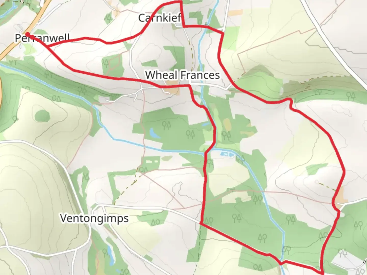
Starting near the charming village of Perranwell in Cornwall, England, the Perranwell Loop is a delightful 7 km (approximately 4.3 miles) trail that offers a moderate challenge with an elevation gain of around 100 meters (328 feet). This loop trail is perfect for those looking to immerse themselves in the picturesque Cornish countryside.### Getting There To reach the trailhead, you can either drive or use public transport. If driving, head towards Perranwell Station, which is a convenient landmark and offers parking facilities. For those using public transport, Perranwell Station is well-served by trains from Truro and Falmouth, making it easily accessible.### Trail Overview The trail begins near Perranwell Station and quickly immerses you in the lush, rolling landscapes that Cornwall is famous for. As you set off, you'll traverse a mix of woodland paths, open fields, and quaint country lanes. The initial section is relatively flat, allowing you to ease into the hike.### Points of Interest
Woodland and Wildlife
Around the 2 km (1.2 miles) mark, you'll enter a dense woodland area. This section is particularly enchanting, with towering trees and a rich undergrowth that provides a habitat for various wildlife. Keep an eye out for deer, foxes, and a variety of bird species. The woodland also offers a cool, shaded respite, especially during warmer months.#### Historical Significance As you continue, you'll come across remnants of Cornwall's mining heritage. Around the 4 km (2.5 miles) point, you'll pass by old mining structures and shafts, a testament to the region's industrial past. These sites are not only historically significant but also add a unique character to the trail.### Elevation and Terrain The trail's elevation gain is gradual, with the most significant climbs occurring between the 3 km (1.9 miles) and 5 km (3.1 miles) marks. The terrain varies from well-trodden paths to more rugged sections, so sturdy hiking boots are recommended. The highest point of the trail offers panoramic views of the surrounding countryside, making the climb well worth the effort.### Navigation Given the mix of terrains and the occasional fork in the path, it's advisable to use a reliable navigation tool like HiiKER to stay on track. The app provides detailed maps and real-time updates, ensuring you won't miss any key turns or landmarks.### Final Stretch The final 2 km (1.2 miles) of the loop bring you back towards Perranwell Station. This section is relatively flat and offers a gentle descent, allowing you to cool down as you approach the end of your hike. Along the way, you'll pass through more open fields and small hamlets, offering a peaceful and scenic conclusion to your journey.### Practical Tips - Footwear: Sturdy hiking boots are recommended due to the varied terrain. - Weather: Check the weather forecast before setting out, as the trail can become muddy and slippery in wet conditions. - Supplies: Carry enough water and snacks, especially if you plan to take breaks and enjoy the scenery. - Wildlife: Be respectful of the local wildlife and maintain a safe distance.The Perranwell Loop is a delightful blend of natural beauty, historical intrigue, and moderate physical challenge, making it a rewarding experience for hikers of all levels.

What to expect?
Activity types
Comments and Reviews
User comments, reviews and discussions about the Perranwell Loop, England.
4.0
average rating out of 5
2 rating(s)