Download
Preview
Add to list
More
31.3 km
~1 day 2 hrs
565 m
Loop
“A 31 km loop of breathtaking views, historical landmarks, and diverse wildlife along South Downs Way.”
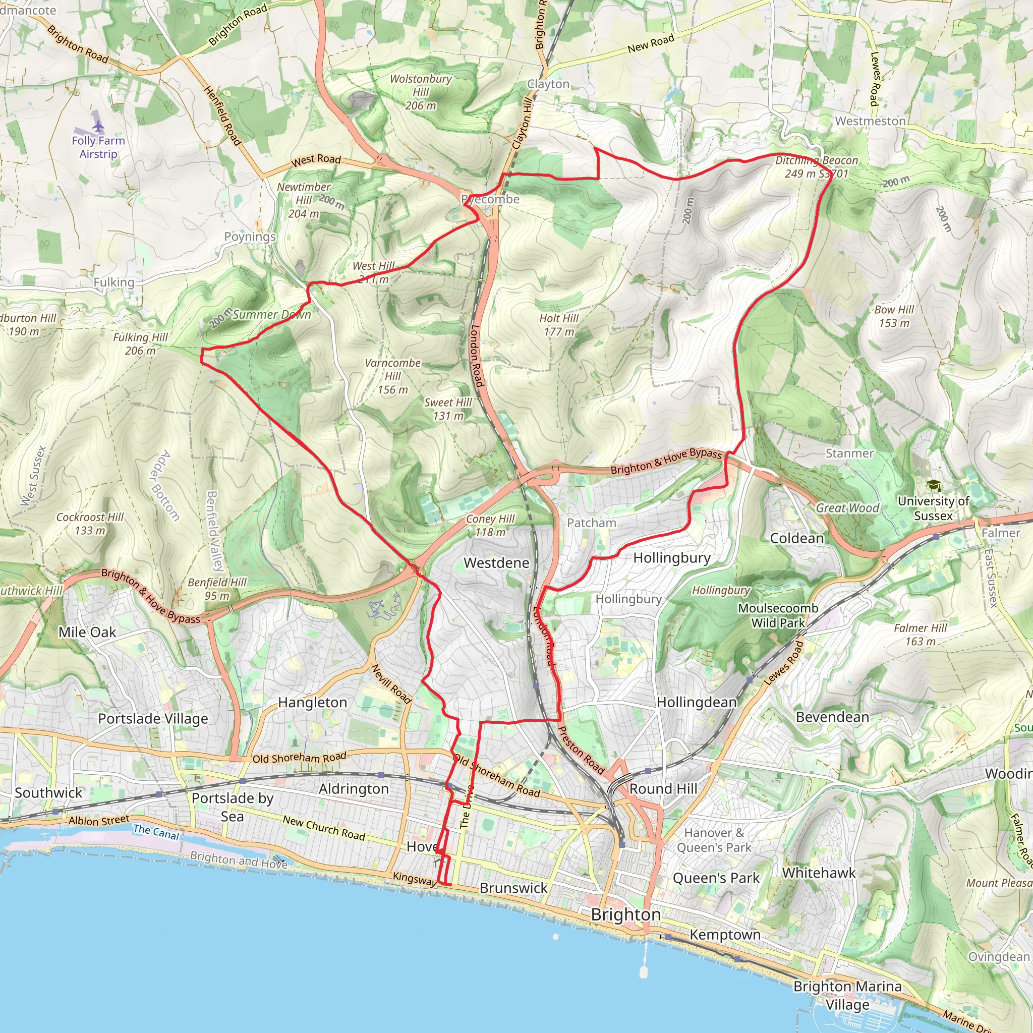
Starting near Brighton and Hove, England, the West Hill, Keymer Post, Ditchling Beacon via South Downs Way trail is a captivating 31 km (19.3 miles) loop with an elevation gain of around 500 meters (1,640 feet). This medium-difficulty trail offers a blend of natural beauty, historical landmarks, and panoramic views, making it a rewarding experience for hikers.
Getting There To reach the trailhead, you can either drive or use public transport. If driving, head towards Brighton and Hove and look for parking options near the South Downs Way. For public transport, take a train to Brighton Station and then a bus towards Ditchling Beacon. The nearest significant landmark to the trailhead is the Ditchling Beacon car park.
Trail Overview The trail begins with a gentle ascent towards West Hill, offering stunning views of the surrounding countryside. As you progress, you'll encounter a mix of open fields and wooded areas, providing a diverse hiking experience. The initial 5 km (3.1 miles) will see you gaining approximately 150 meters (492 feet) in elevation, setting the stage for the more challenging sections ahead.
Keymer Post Around the 10 km (6.2 miles) mark, you'll reach Keymer Post, a notable waypoint on the South Downs Way. This area is rich in history, with ancient pathways that have been used for centuries. Take a moment to appreciate the historical significance and enjoy the expansive views of the South Downs National Park.
Ditchling Beacon The trail then leads you to Ditchling Beacon, the highest point in East Sussex at 248 meters (814 feet). This section, approximately 15 km (9.3 miles) into the hike, offers some of the most breathtaking views of the entire trail. On a clear day, you can see as far as the coast and the rolling hills of the South Downs. The climb to Ditchling Beacon is steep but manageable, with an elevation gain of about 200 meters (656 feet) over 3 km (1.9 miles).
Wildlife and Nature The South Downs Way is home to a variety of wildlife, including deer, foxes, and numerous bird species. Keep an eye out for skylarks and kestrels soaring above. The flora is equally impressive, with wildflowers such as orchids and cowslips dotting the landscape, especially in the spring and summer months.
Navigation Given the length and complexity of the trail, it's advisable to use a reliable navigation tool like HiiKER to ensure you stay on track. The trail is well-marked, but having a digital map can provide additional peace of mind.
Final Stretch The final 10 km (6.2 miles) of the loop take you through a series of rolling hills and picturesque villages. The descent is gradual, allowing you to enjoy the scenery without too much strain. As you approach the end of the trail, you'll pass through lush meadows and farmland, offering a serene conclusion to your hike.
Historical Significance The South Downs Way has been a significant route for centuries, used by traders, pilgrims, and even Roman soldiers. The trail itself is a testament to the rich history of the region, with ancient barrows and hill forts scattered along the way.
This 31 km loop is a perfect blend of natural beauty, historical intrigue, and physical challenge, making it a must-do for any avid hiker.
What to expect?
Activity types
Comments and Reviews
User comments, reviews and discussions about the West Hill, Keymer Post, Ditchling Beacon via South Downs Way, England.
4.0
average rating out of 5
3 rating(s)

