Download
Preview
Add to list
More
17.5 km
~3 hrs 46 min
169 m
Point-to-Point
“Embark on a scenic 18 km hike through lush forests, ancient forts, and royal parks near Bracknell, England.”
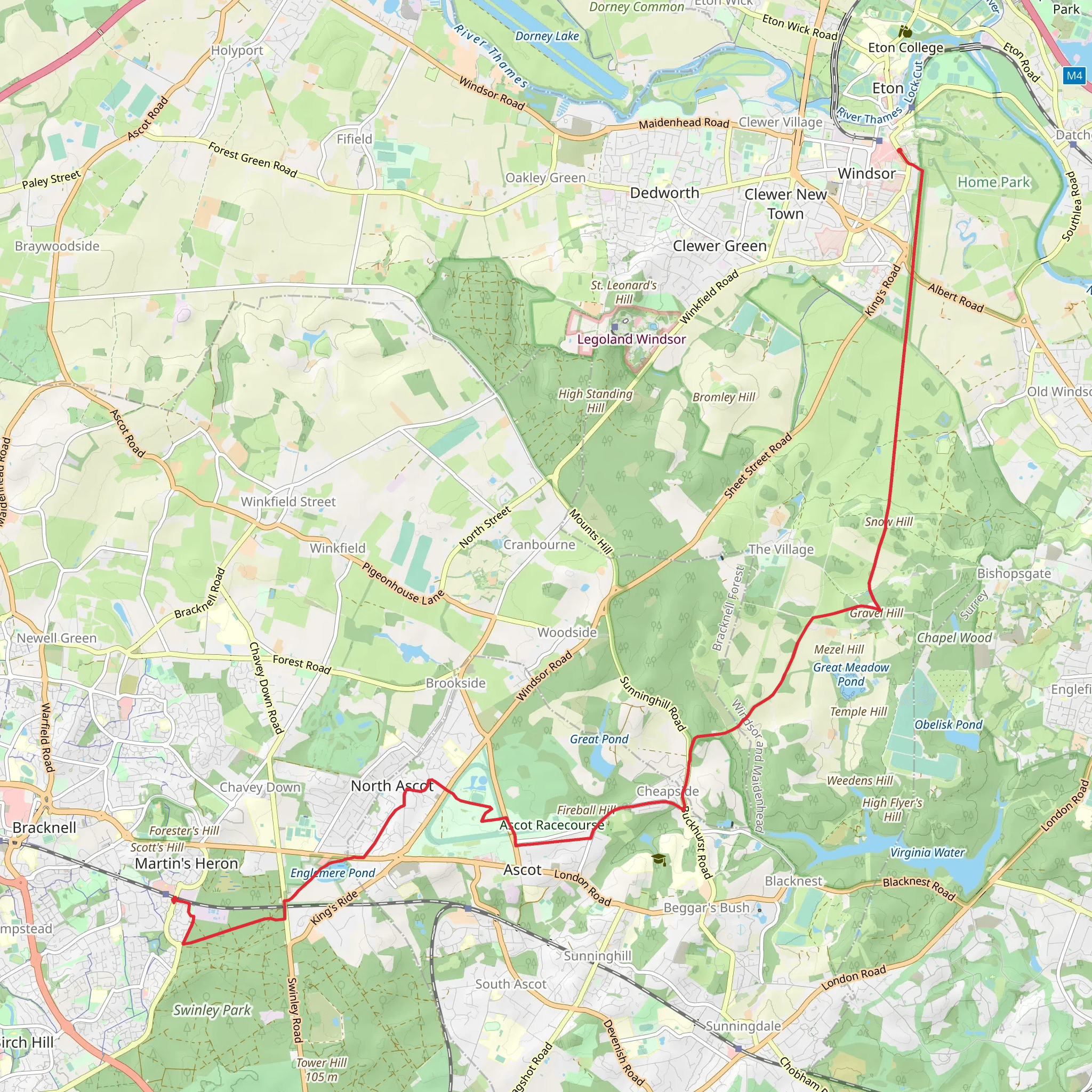
Starting near Bracknell Forest in England, this 18 km (approximately 11 miles) point-to-point trail offers a delightful mix of natural beauty and historical intrigue. With an elevation gain of around 100 meters (328 feet), the trail is estimated to be of medium difficulty, making it accessible to a wide range of hikers.### Getting There To reach the trailhead, you can either drive or use public transport. If driving, head towards Bracknell Forest and look for parking options near the forest entrance. For those using public transport, the nearest train station is Bracknell, which is well-connected to London and other major cities. From the station, you can take a local bus or taxi to the trailhead.### Trail Overview The trail begins near Bracknell Forest, a lush area known for its dense woodlands and diverse wildlife. As you start your hike, you'll be greeted by towering trees and the soothing sounds of nature. The first few kilometers are relatively flat, allowing you to ease into the hike.### Significant Landmarks and Nature Around the 5 km (3.1 miles) mark, you'll come across Caesar's Camp, an ancient hill fort that dates back to the Iron Age. This site offers a glimpse into the region's rich history and provides a great spot for a short break. The elevation here is minimal, making it an easy climb to explore the fort.Continuing on, you'll pass through Swinley Forest, a popular spot for mountain biking and bird watching. Keep an eye out for local wildlife such as deer, foxes, and a variety of bird species. The forest is also home to several rare plants, so take your time to appreciate the flora.### Midway Point At approximately 10 km (6.2 miles), you'll reach the village of Ascot, famous for its racecourse. If you're hiking during the racing season, you might catch a glimpse of the excitement from a distance. Ascot offers a few local pubs and cafes where you can refuel before continuing your journey.### Final Stretch The last segment of the trail takes you through Windsor Great Park, a sprawling area with manicured gardens, ancient oak trees, and serene lakes. The park is steeped in history, having been a royal hunting ground for centuries. As you walk through, you'll see the Long Walk, a straight path that leads directly to Windsor Castle. This iconic view is a highlight of the trail and a perfect spot for photos.### Navigation and Safety Given the length and varied terrain of the trail, it's advisable to use a reliable navigation tool like HiiKER to keep you on track. The trail is well-marked, but having a digital map can provide extra assurance. Make sure to carry enough water, snacks, and a basic first-aid kit. The weather can be unpredictable, so pack layers and waterproof gear.### Wildlife and Conservation Throughout the hike, you'll encounter various ecosystems, from dense forests to open meadows. The area is part of several conservation efforts aimed at preserving its natural beauty and biodiversity. Respect the local wildlife by keeping a safe distance and sticking to marked paths.This trail offers a perfect blend of natural beauty, historical landmarks, and a moderate challenge, making it a rewarding experience for any hiker.
What to expect?
Activity types
Comments and Reviews
User comments, reviews and discussions about the Martin Herons to Windsor Walk, England.
5.0
average rating out of 5
1 rating(s)

