Download
Preview
Add to list
More
41.4 km
~2 day
2514 m
Out and Back
“The Toro Peak trail offers seasoned hikers breathtaking vistas, diverse ecosystems, and rich historical insights.”
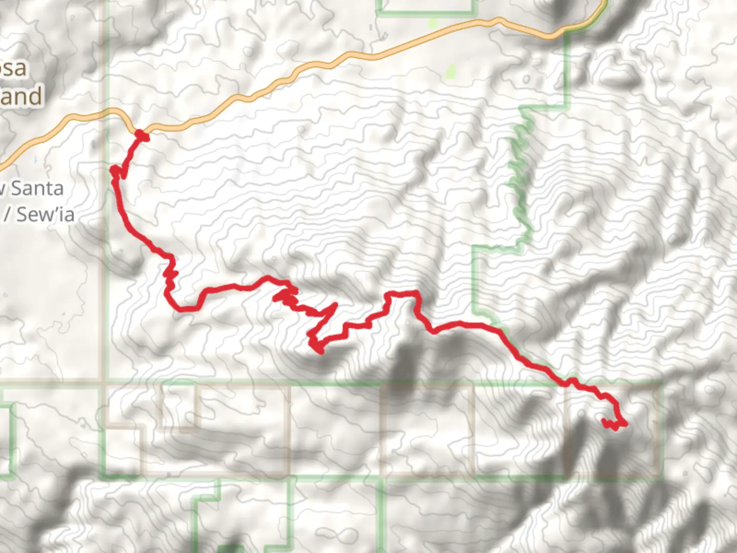
Nestled in the rugged terrain of Riverside County, California, the Toro Peak via Santa Rosa Road - Long trail offers an exhilarating adventure for seasoned hikers. Spanning approximately 41 kilometers (about 25.5 miles) with an elevation gain of around 2500 meters (8200 feet), this out-and-back trail is rated as difficult, demanding both physical endurance and careful planning.### Getting ThereThe trailhead is conveniently located near Riverside County, accessible by car. If you're traveling from Los Angeles, take the I-10 E towards Palm Springs, then merge onto CA-111 S. Continue on CA-74 E until you reach Santa Rosa Road. Public transport options are limited, so driving is recommended. Parking is available near the trailhead, but it's wise to arrive early, especially on weekends, to secure a spot.### Trail OverviewThe journey begins with a gradual ascent through the Santa Rosa and San Jacinto Mountains National Monument. The initial stretch is characterized by a mix of desert scrub and chaparral, offering a glimpse into the diverse ecosystems of Southern California. As you progress, the trail becomes steeper and more challenging, with rocky sections that require careful footing.### Significant Landmarks and NatureAround 10 kilometers (6.2 miles) into the hike, you'll encounter the first major landmark: the expansive views of the Coachella Valley. This vantage point provides a breathtaking panorama, especially during sunrise or sunset. Continuing onward, the trail meanders through dense pine forests, a stark contrast to the arid landscape below.At approximately 20 kilometers (12.4 miles), you'll reach the summit of Toro Peak, the highest point in the Santa Rosa Mountains. Standing at an elevation of 2,671 meters (8,760 feet), the peak offers unparalleled views of the Salton Sea to the east and the San Jacinto Mountains to the west. On clear days, you might even catch a glimpse of the distant San Bernardino Mountains.### Wildlife and FloraThe trail is home to a variety of wildlife, including mule deer, bobcats, and the elusive mountain lion. Birdwatchers will delight in spotting species such as the California quail and the red-tailed hawk. The flora is equally diverse, with yucca, manzanita, and Jeffrey pine dotting the landscape. Springtime hikers will be treated to a vibrant display of wildflowers, adding a splash of color to the rugged terrain.### Historical SignificanceThe region holds historical significance, having been inhabited by the Cahuilla people for centuries. They utilized the area's natural resources for food, medicine, and shelter. As you hike, you may come across ancient petroglyphs and grinding stones, remnants of their rich cultural heritage.### Navigation and SafetyGiven the trail's difficulty, it's crucial to be well-prepared. Use HiiKER for accurate navigation and trail conditions. Ensure you have adequate water, as sources are scarce along the route. Weather can be unpredictable, with temperatures varying significantly between the base and the summit. Layered clothing, sun protection, and sturdy hiking boots are essential.Embarking on the Toro Peak via Santa Rosa Road - Long trail promises a challenging yet rewarding experience, offering a unique blend of natural beauty, wildlife, and historical intrigue.

What to expect?
Comments and Reviews
User comments, reviews and discussions about the Toro Peak via Santa Rosa Road - Long, California.
average rating out of 5
0 rating(s)