Old Big Oak Flat Road, El Capitan, Eagle Peak, Yosemite Point and Snow Creek Trail
Download
Preview
Add to list
More
47.3 km
~2 day
1951 m
Point-to-Point
“Explore Yosemite's heart on a challenging trail with breathtaking vistas and rich historical landmarks.”
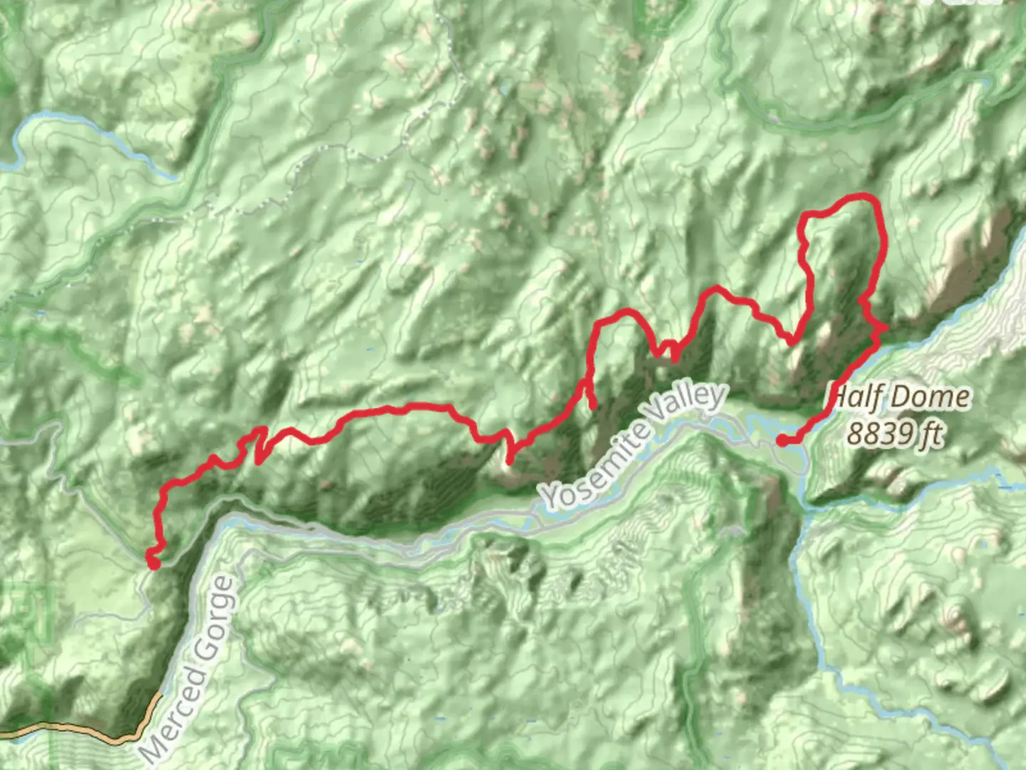
Starting your adventure near Mariposa County, California, the Old Big Oak Flat Road, El Capitan, Eagle Peak, Yosemite Point, and Snow Creek Trail is a challenging yet rewarding journey through the heart of Yosemite National Park. Spanning approximately 47 kilometers (about 29 miles) with an elevation gain of around 1,900 meters (6,234 feet), this point-to-point trail offers a diverse array of landscapes, historical landmarks, and breathtaking vistas.
Getting There
To reach the trailhead, you can drive to Yosemite National Park, which is accessible via Highway 140 from Merced or Highway 120 from Manteca. For those relying on public transport, the YARTS (Yosemite Area Regional Transportation System) provides bus services from various locations, including Merced and Fresno, directly to Yosemite Valley. Once in the park, shuttle services can help you reach the starting point near the Big Oak Flat Entrance.
Trail Highlights
Old Big Oak Flat Road: The journey begins on the historic Old Big Oak Flat Road, a remnant of the original route into Yosemite Valley. As you traverse this section, imagine the early pioneers and travelers who once used this path to access the park's wonders. The road is now a trail, offering a glimpse into the past with its rugged terrain and remnants of old infrastructure.
El Capitan: As you continue, the trail takes you near the base of El Capitan, one of the most iconic granite monoliths in the world. Standing at over 900 meters (3,000 feet) tall, El Capitan is a favorite among rock climbers and a sight to behold. Keep an eye out for climbers scaling its sheer face, and take a moment to appreciate the grandeur of this natural wonder.
Eagle Peak and Yosemite Point: Further along, the trail ascends to Eagle Peak, offering panoramic views of the valley below. At an elevation of approximately 2,500 meters (8,200 feet), this is one of the highest points on the trail. Continuing to Yosemite Point, you'll be rewarded with stunning vistas of Half Dome and the surrounding wilderness. These vantage points are perfect for photography and soaking in the beauty of Yosemite.
Snow Creek Trail: The final section of the trail descends via the Snow Creek Trail, which winds through lush forests and alongside the cascading waters of Snow Creek. This part of the hike is known for its serene atmosphere and opportunities to spot wildlife, including deer and various bird species. The descent can be steep, so take care with your footing.
Navigation and Preparation
Given the trail's difficulty, it's essential to be well-prepared. Use HiiKER for detailed maps and navigation tools to ensure you stay on course. The trail can be strenuous, with significant elevation changes, so adequate fitness and preparation are crucial. Carry enough water, snacks, and layers to accommodate changing weather conditions.
Historical Significance
Yosemite National Park is steeped in history, from its geological formations to its cultural heritage. The park was central to the conservation movement in the United States, with figures like John Muir advocating for its protection. As you hike, consider the historical significance of the land and the efforts made to preserve its natural beauty for future generations.
Embarking on this trail is not just a physical journey but a passage through time, offering insights into the natural and cultural history of one of America's most treasured landscapes.

What to expect?
Activity types
Comments and Reviews
User comments, reviews and discussions about the Old Big Oak Flat Road, El Capitan, Eagle Peak, Yosemite Point and Snow Creek Trail, California.
average rating out of 5
0 rating(s)