Download
Preview
Add to list
More
42.7 km
~2 day
2925 m
Out and Back
“Tackling the rugged Shepherd Pass Trail offers breathtaking views and a deep dive into Sierra Nevada's history.”
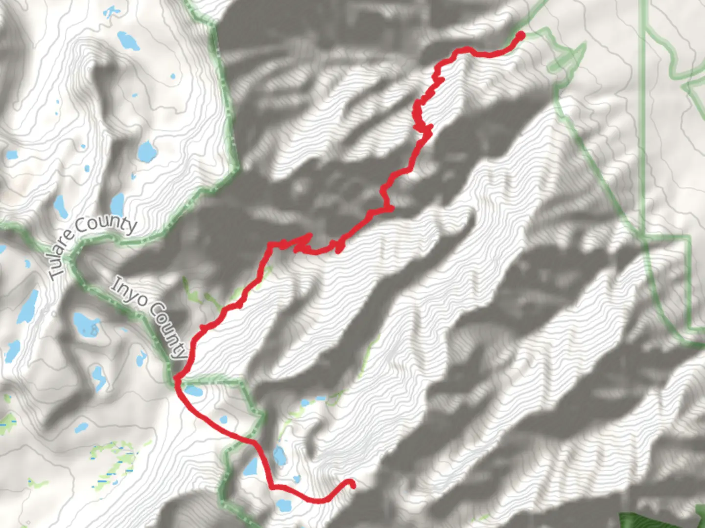
Embarking on the Mount Williamson via Shepherd Pass Trail is a journey into the heart of California's rugged Sierra Nevada. This challenging out-and-back trail stretches approximately 43 kilometers (about 27 miles) with a formidable elevation gain of around 2,900 meters (9,514 feet). The trailhead is located near Inyo County, California, and is known for its demanding terrain and breathtaking vistas.
Getting There
To reach the trailhead, travelers can drive to the Shepherd Pass Trailhead, which is accessible via Foothill Road off Highway 395, near the town of Independence, California. For those relying on public transport, the Eastern Sierra Transit Authority provides bus services to Independence, where you can arrange for a taxi or shuttle to the trailhead. Ensure you have a reliable vehicle, as the road to the trailhead can be rough and requires careful navigation.
Trail Overview
The trail begins with a steep ascent, immediately challenging hikers with its rigorous elevation gain. The initial section winds through sagebrush and desert scrub, gradually transitioning into a more alpine environment. As you ascend, the landscape transforms, offering views of the Owens Valley and the distant White Mountains.
Significant Landmarks
- Symmes Creek: Early in the hike, you'll cross Symmes Creek, a refreshing spot to pause and enjoy the sound of flowing water. This creek is a vital water source, so ensure you have a filtration system if you plan to refill your water supply.
- Shepherd Pass: At approximately 16 kilometers (10 miles) into the hike, you'll reach Shepherd Pass, a significant milestone. The pass sits at an elevation of about 3,658 meters (12,000 feet) and offers panoramic views of the surrounding peaks. This is a challenging section, often covered in snow well into the summer months, so be prepared for icy conditions.
- Williamson Bowl: Beyond Shepherd Pass, the trail descends into the Williamson Bowl, a rugged basin dotted with glacial lakes. This area is known for its stark beauty and is a prime spot for observing the region's unique geology.
Flora and Fauna
The trail traverses diverse ecosystems, from arid desert landscapes to lush alpine meadows. Keep an eye out for mule deer, marmots, and the occasional black bear. Birdwatchers may spot golden eagles and peregrine falcons soaring above the peaks. The flora varies with elevation, featuring sagebrush at lower levels and vibrant wildflowers in the alpine zones during the summer months.
Historical Significance
The Sierra Nevada range has a rich history, with roots in Native American culture and the California Gold Rush. The region was historically inhabited by the Paiute people, who traversed these mountains long before modern trails were established. The area also played a role during the westward expansion, with miners and settlers forging paths through these formidable peaks.
Navigation and Safety
Given the trail's difficulty, it's crucial to be well-prepared. Use the HiiKER app for accurate navigation and trail conditions. Weather in the Sierra Nevada can be unpredictable, with sudden storms and temperature drops, so pack accordingly. Ensure you have adequate supplies, including food, water, and emergency gear, and always inform someone of your hiking plans.
The Mount Williamson via Shepherd Pass Trail is not for the faint-hearted, but for those who undertake it, the rewards are immense. The combination of challenging terrain, stunning natural beauty, and historical depth makes this trail a truly unforgettable experience.

What to expect?
Activity types
Comments and Reviews
User comments, reviews and discussions about the Mount Williamson via Shepherd Pass Trail, California.
average rating out of 5
0 rating(s)